It’s another warm morning across Houston, with temperatures generally having fallen only to about 70 degrees. The main concern today will be the possibility of some storms and heavy rain along with the passage of a cold front.
Today
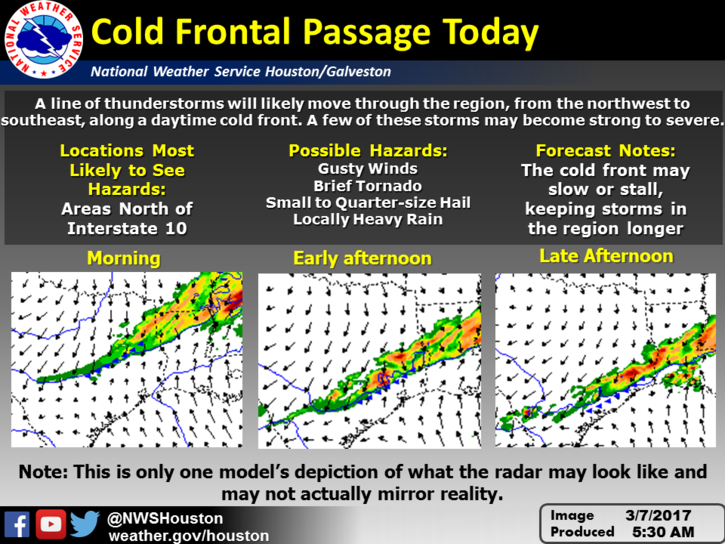
A cold front now in north Texas will move down toward the Houston area, likely pushing through the city during the mid-afternoon hours, and the off the coast by late afternoon. Due to decent moisture levels and and lift associated with the front, much of the area is likely to see some moderate to briefly heavy rain with the front’s passage. I’m expecting on the order of 0.5 inch to 1.0 inch or so, late this morning and during the afternoon hours. The storms may slow, or even stall along the cost, producing more rain there. Along with the front there will likely be some embedded thunderstorms, and a slight chance of some hail. After the front passes tonight look for temperatures to fall into the mid- to upper-50s.
Wednesday
With northerly winds and partly cloudy skies the day will be moderately cooler, with highs in the low 70s. A very slight chance of rain returns during the late afternoon and evening hours. Most of the cooler air is gone by Wednesday night, allowing low temperatures to fall only into the 60s.
(Space City Weather is sponsored this month by an anonymous donor.)
Thursday and Friday
As moisture levels rise, we’ll again see some moderate rain chances toward the end of the work week, especially during the time frame of Friday afternoon or evening. These rains won’t be anything to write home about, maybe a few tenths of an inch, but might put a damper on Friday evening activities. Highs both days will be in the upper 70s.
This weekend
Some light showers will be possible on Saturday, with another day in the upper 70s, and mostly cloudy skies. A cold front will reach the area Saturday night or Sunday morning, and with it we’re going to see another line of showers and possibly thunderstorms. These should clear out fairly quickly on Sunday morning, however. Sunday should be a really nice day after the front passes, with clearing skies and highs in the mid-70s.
Next week
At this point much of next week looks to be a little cooler, with highs in the low 70s and lows in the low 50s. Still quite a lot of time for that to change, but it should more or less be normal for spring time.
Rice Design Alliance event
If you’re interested in the present and future of living in flood plains, I’ll be moderating a Rice Design Alliance civic forum on Wednesday evening at the Cherie Flores Garden Pavilion inside the McGovern Centennial Gardens at Hermann Park. The program is free, and begins at 6pm CT.
Posted at 6:50am CT on Tuesday
Say, why don’t we grab some of that polar vortex about to slam the Northeast this weekend? Something like -54C in the Northwest Territories right now….
I’d like just a relly thin slice of that…..
For Saturday, Eric, I see a fairly progressive system, with the most active weather to occur overnight Sunday morning with the front well off the coast by sunrise. It’s a quick hitter with average 0.25-0.50 inch amounts, similar thermodynamic indices as today’s system. I suppose the front could have similar threats…..but somehow, I don’t think so, as it’s got the disadvantage of occurring during the overnight hours.
Your thoughts, Eric?
Agree with your assessment. Threat of severe weather is fairly low.