Back in November, meteorologists were euphoric as a satellite named GOES-R (now GOES-16) was launched into orbit. “GOES” stands for “Geostationary Operational Environmental Satellite.” For meteorologists, it represents the future of weather observation from space. The satellite is now sending back imagery and data in an experimental, non-operational capacity. GOES-16 will be declared operational and unleashed for use in forecasting and observations later this year.
There’s a lot to love in GOES-16. We’ll have higher resolution imagery from a satellite than we’ve ever had in North America. In fact, at times, the satellite will be capable of sending back pictures every 30 seconds. By comparison, that’s more frequent than what a land-based Doppler radar typically scans. It will have 16 bands of imagery compared to five bands on the current GOES fleet. These satellites will give us more to look at, more to study, and more high quality data that will be ingested in weather models to help with short and medium range forecasts. It will also have the ability to see lightning.
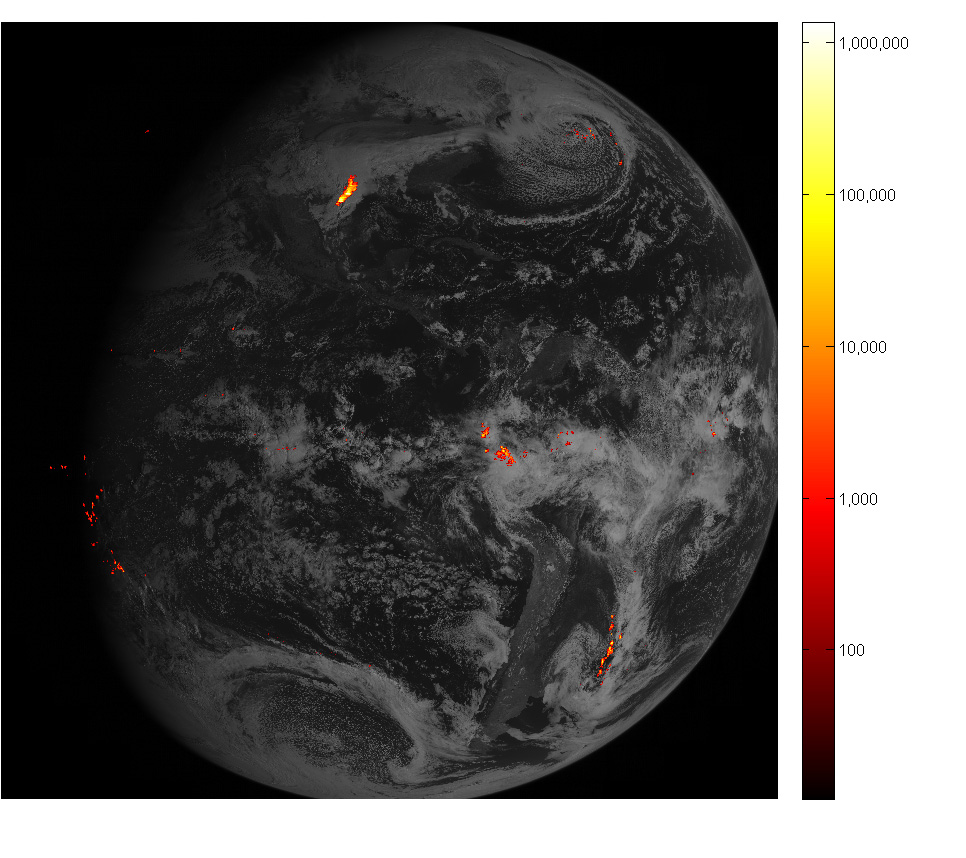
Geostationary Lightning Mapper
The geostationary lightning mapper, or GLM, attached to GOES-16 can detect changes in a scene that indicate there’s lightning present. It’s the first such operational lightning mapper in orbit. The GLM will give us a capability to see and study lightning in a brand new way. It will also allow us to build up a historical database of lightning across much of the Western Hemisphere, including the tropics and deep oceans, where we lack a lot of good observational data. Best of all, it will allow for some really cool visualizations of storms.
In a real treat for us as Houston meteorologists, the first imagery from the GLM was released today. It just so happens to be from the severe weather and tornado outbreak of Valentine’s Day last month. Several tornadoes touched down south and west of Houston from a series of storms that were wild to say the least.
The imagery above shows Valentine’s Day in Houston at around 8:45 AM, when storms were near their peak. The movie above is shown at 25 frames per second, which is basically what you would see if you were in space above Houston on Valentine’s Day. This technology will allow us to monitor how frequently lightning is occurring, giving us a new tool to assess how quickly or slowly a storm is intensifying, if it risks stalling, and can help lead to more refined warnings during significant weather. And on top of all this, it’s really, really cool looking.
This is incredibly exciting data, and it will revolutionize how we view storms. It should hopefully lead to promising research on thunderstorms and weather systems (I do think this will lead to interesting research in the tropics specifically).
The Future
Meanwhile, the next satellite in the GOES fleet will be GOES-S, launching in mid-2018. These satellites are critical pieces for the future of weather forecasting. Recent years have seen incredible strides made in weather forecasting. Yes, we’re still far from perfect (as evidenced by this weekend’s significant rain event around Houston).
It was concerning and somewhat disheartening to learn this weekend that the budget being proposed by the White House cuts the National Oceanic and Atmospheric Adminstration’s satellite program by over 20 percent. Cuts to the satellite program are in addition to cuts to other important weather and climate programs within NOAA, including the already understaffed and underfunded National Weather Service. Yes, these cuts will severely curtail NOAA’s ability to study climate change. But an unintended consequence of this will also be a very detrimental impact to daily weather forecasting improvements. I can’t overstate how much value these satellites are going to add to daily, weekly, and longer-term weather forecasting.
While getting our fiscal house in order in Washington is important, the impact to NOAA and the NWS is disproportionate. No, these organizations aren’t immune from some added oversight and belt-tightening. The wrong approach however is taking a machete to these programs as currently proposed. Deep cuts will have significant and long-lasting negative impacts on weather forecasts. In flood and hurricane-prone Houston, we believe it behooves our elected officials to push back hard against these kind of cuts.
Matt, your kid-in-a-candy-store excitement about GOES-16 really shines through. Made an interesting post even more fun to read. 🙂
I agree with you on the cuts. Immediate savings in such a case will likely (if not definitely) turn out to be more expensive overall in the long run.
Thank you! You’re exactly right. I’m totally sympathetic to arguments about being more fiscally responsible. I’m not for doing things without much thought for consequences. I’m hopeful folks in DC see that. We’ll see.
Really cool to see how the lightning concentrates in the higher topped storms in that video.
“And on top of all this, it’s really, really cool looking.”
The most important feature!
Matt, do you think these cuts could allow private sector of the weather industry to grow? I’ve noticed that some of the private weather forecasting companies that already exist, such as accuweather and weather channel, are sometimes more accurate than NWS and at no charge. I realize that most local meteorologists use the NWS as a base model before adding their own interpretation. But if more private companies launched their own satellites through competition, this could give meteorologists more information and more options for giving their forecasts.
Yes, it would almost have to grow because there would be a tremendous gap in coverage. That said, NOAA has the experience and the infrastructure to do this now, so in my view, yes the private sector could step in, but then you have a situation where a.) they lack experience and b.) you get into proprietary issues. Private sector won’t provide this information free of charge. It gets to be a slippery slope, and I’m not at all convinced the private sector can do it objectively and/or better.
Pretty cool stuff.
Any chance a private entity could launch these types of technology and be profitable?
See my reply to weathernut. They probably could, but I would have significant concerns and doubts about quality and objectivity.