Good afternoon. The atmosphere has behaved itself so far today, with most of the area seeing one-half inch of rainfall, or less, since sunrise. We expect this trend to continue today and tonight. Yes, rain will be possible. No, it should not be extreme.
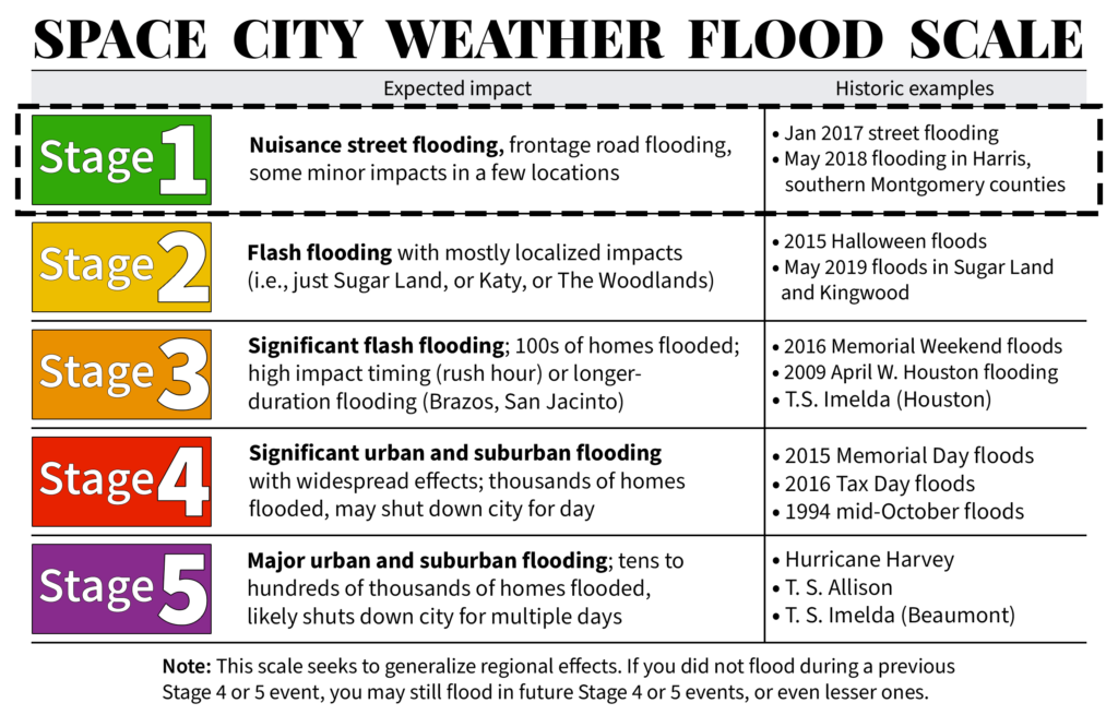
Overall, we think the threat of a big ticket rainfall event—which will lead to significant flooding—is diminishing this week. Therefore we are lowering out Space City Weather Flood Scale alert level to Stage 1. This means we can mostly expect nuisance street flooding over the next couple of days.

That’s not to say the rain is over.
Showers will continue to be possible along the coast this afternoon and tonight. On Thursday, we expect showers to be more scattered in nature, offering a nice reprieve. But beginning Thursday night we could see redevelopment of more widespread activity, and then the potential for moderate or even heavy briefly rainfall on Friday and into Saturday morning. Overall accumulations will likely be in the neighborhood of 1 to 3 inches of rainfall, with higher isolated amounts possible south of Interstate 10, closer to the coast, and east of Houston. Even though the region’s soils are saturated, we just don’t see a huge threat to the metro area. Obviously, we’ll be tracking things closely until the risk is over.
Unless there’s a change in our thinking, we’ll next update on Thursday morning.
We’re getting drenched in Angleton. I would guess we have seen more than a half inch to an inch in the last hour alone.
Thanks!
While not asking for my specific neighborhood :-), I’m curious when y’all say the Houston metro area, does that include Galveston/ Galveston County/ or southern Harris County?
I’m curious because I’d like to know what I could be dealing with on the drive south on Friday and I’m not sure what you mean by Houston metro.
Thank you so much for what y’all do.
While I shouldn’t answer for the guys, but most folks think of Houston metro area as inside Beltway 8….
Also not speaking for the guys, the official OMB definition includes these counties: Austin, Brazoria, Chambers, Ft Bend, Galveston, Harris, Liberty, Waller, and Montgomery.
What does OMB mean?
Maybe Office of Management and Budget, a government office.
What do you see for the area within City of Houston south of Beltway 8, Clear Lake Area (east of I-45 between Clear Lake City Blvd and Nasa Road) and Friendswood (west of I-45 from Fm 1959 to FM 528)?
That’s a pretty vague location description, can you be a little more precise :o)
I really hope that this is sarcasm and I’m just missing it. Good grief
I am glad to have you guys to turn to because the local guys are still touting 2-4″ today, tomorrow and 1-2″ Friday – which of course would not justify lowering to Stage 1. i will trust your analysis, thank you very much!
The Houston metro area includes: Harris, Montgomery, Chambers, Galveston, Brazoria, Fort Bend and Waller Counties.
Go and search online for “Houston metropolitan area map,” and that will help put context into the size of this region for people who aren’t aware, or just moved.
Oops! I see I left off Austin and Liberty Counties! Both of those counties are mostly rural, and are far from the main urban area of Houston.
I live out in Austin county, and it must have been added some time recently, like within the last couple of years or so. For the longest time I was only aware of the 7 counties you listed as comprising the “greater Houston metro area”, guess we were bound to be added at some point.
I am here in Sienna SBE. One of my close neighbors has a Weather Underground PWS that I monitor. That mess last night dropped 2.47″ in 80 minutes. The peak rate was 3.09″/h. That was truly a deluge, the freight train you mentioned. Since this all started on Sunday, this PWS has recorded 5.11″ through midnight last night. Today so far, has added another 1.61″ to the total and it is still raining lightly. So, an overall total so far of 6.72″.
curious question. since I turned on the TV last night, the over-the-air signal has been cr*p. sometimes happens when there is lots of lightning in the City (wasn’t even close to me yet). but this evening as well, OTA signal is so degraded to be near 100% unusable. would the atmospheric energies that these storms depend on make a bother in the digital TV signal bands (we can’t call it VHF anymore, or can we)?
I have OTA also and I notice the same effect related to changes in the weather. Not 100% degraded where I am today, but channel 13 has been nothing but scrambled lately if I can get it at all. So yes, there does seem to be some kind of relationship. But I notice similar issues with my cell phone signal when the weather is bad too. And of course, it is commonly known that when it rains, satellite TV doesn’t work either. It is interesting. BTW, when helicopters fly overhead, my TV signal gets disrupted until they pass.
I’ve noticed tonight, Wednesday night, that the future radar is showing this mess coming back up from offshore, and moving towards the northeast, and back down to the southeast. Will this continue into Thursday and come around and hit us again? I cannot remember what this pattern is called, but the rotation is like that of a TD or hurricane low pressure system.
Sorry. I meant northwest and southwest