I have to admit, I enjoyed Eric’s somewhat euphoric post at midnight. Though as the parent of a toddler and infant that slept — how can I say this? — poorly, for lack of a better word, it was a long night. I’m sure many of you with kids and pets can relate!
But seriously, although it was a wild evening, the city of Houston and most of the metro area are doing fine this morning.
Flood Scale remains Stage 2
That said, I am going to hold our flood alert at Stage 2 out of an abundance of caution. Based on model data, I think most areas north of I-10 are realistically down to Stage 1 concerns going forward, as most rain is projected to fall south of I-10 today. Given some heavier rains already this week south of Houston (and east of Houston), I just think we should hold at Stage 2 and watch the next cluster of storms later this morning and afternoon that may graze those areas, and just make sure tonight looks to avoid anything serious in Houston. Forecasting this has been and remains tricky, and as expected, the evolution of the storms has not gone quite as modeling suggested even 1 to 2 days ago.
The NWS intends to keep Flash Flood Watches going through midday Thursday for the entire area.
Water levels
A look at the Harris County Flood Control map of water levels as of 6 A.M. shows only a handful nearing bankfull or out of their banks.
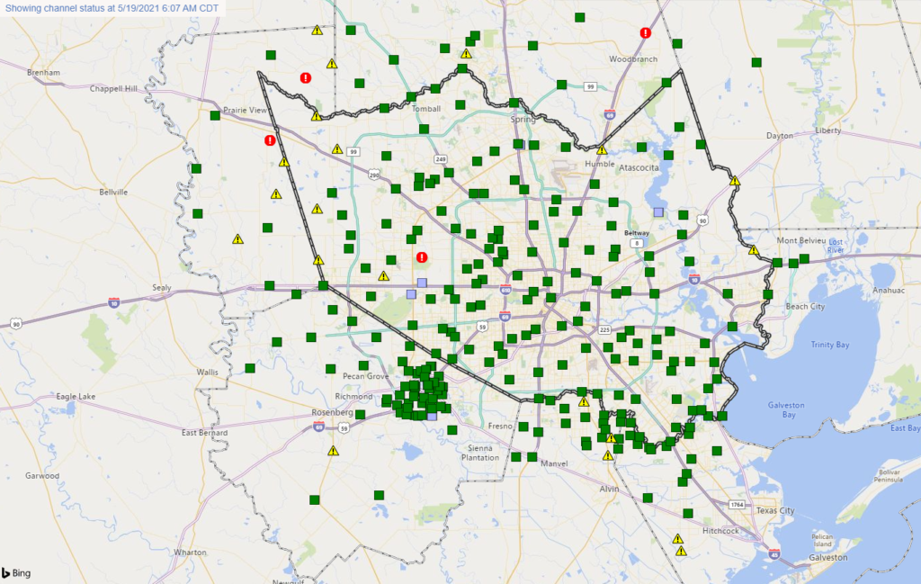
Expect just some minor lowland flooding in spots.
We will need to watch some primary river levels in the coming days, particularly southwest of Houston (though the Brazos looks to remain below flood stage in our area for now), as well as the Trinity River east of the city, which is currently forecast to approach major flood stage at Liberty by the weekend.
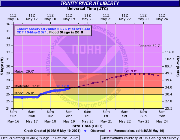
This would yield significant lowland flooding and some house flooding potentially as well. We’ll keep you posted on this, as there could still be some changes to river forecasts as the future rainfall forecasts are revised.
Today
Rain continues in the Houston area this morning, but it’s falling at the rate of about a quarter-inch or less an hour. That is manageable and should not cause any additional serious trouble.
Our attention will focus to another cluster of storms developing over Mexico this morning. The good news is that this seems to be lined up to stay well south of virtually the entire Houston area. We’ll probably see rain or showers continue through mid-morning, and there will continue to be a chance of showers through the afternoon. But any organized, heavy rainfall likely stays well south of Houston.
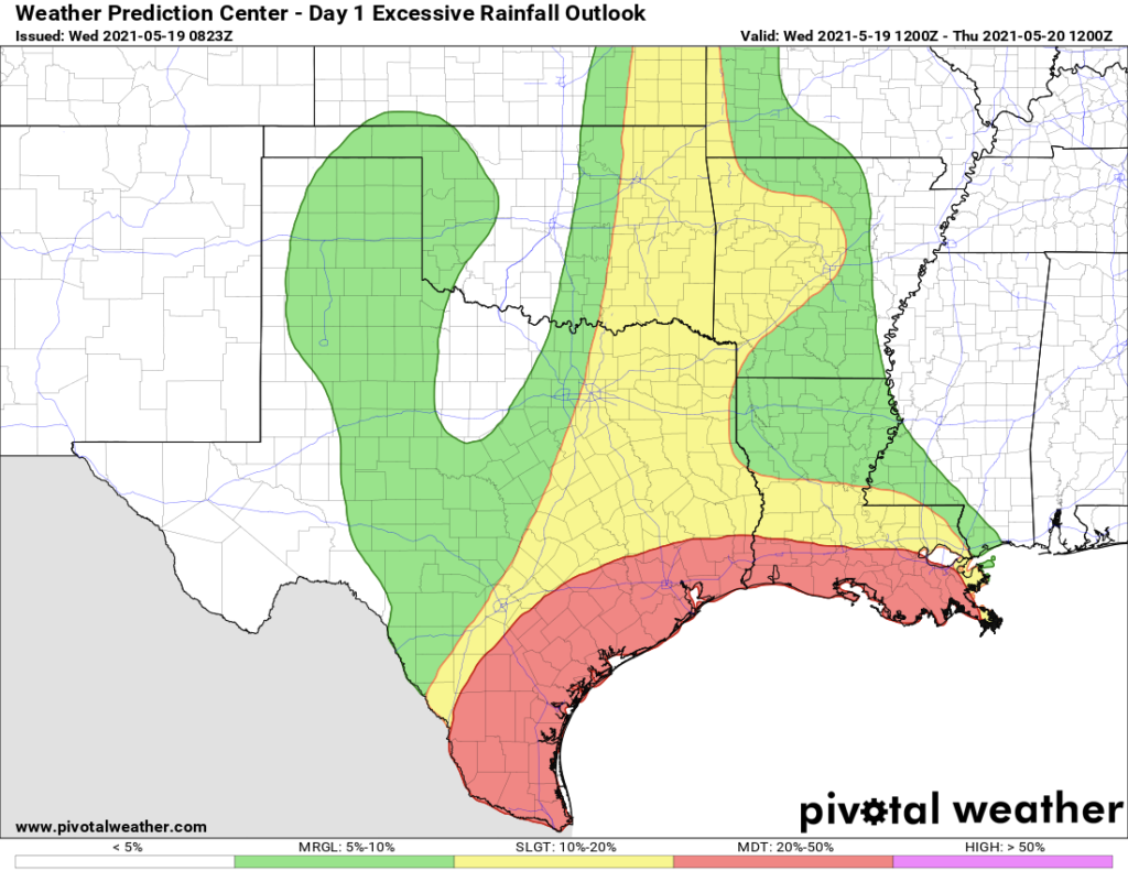
The Weather Prediction Center arm of NOAA continues a moderate risk of excessive rainfall, essentially from I-10 south to the coast. And this may even be skewed a bit far north given trends on models this morning. The biggest problems will most likely be from Matagorda County south past Corpus Christi. But if current trends hold, even Matagorda County may not be too bad. But they have seen 3 to 4 inches of rain since midnight south of Bay City.
Tonight and Thursday
The good news is that it appears that models have tapped the brakes a bit on significant, widespread heavy rainfall in this timeframe. That doesn’t mean it won’t rain. It also doesn’t mean we’re entirely out of the woods with respect to flooding risk. But at this point, there seems to be a lack of model data arguing for serious rainfall tonight or tomorrow.
So, let’s call it a chance of showers and thunderstorms at virtually any time tonight or tomorrow. If a storm does develop it will be capable of producing heavy rainfall. But at this point we don’t expect significant, widespread rainfall. We’ll continue to monitor for any changes.
Friday
There are some indications on models that the atmosphere may recharge a good bit by Friday, with more available atmospheric moisture. This could lead to another round of heavy rain and storms, but details are fuzzy. This might be a period to keep an eye on though. Improving conditions will arrive this weekend.
Eric will have our next update before 2 P.M.
You can tell when Cypress Creek is getting pretty high in the Champions area when people go out and gawk at it. There were a handful of people this morning, like me. I’d say it’s about 6 feet from the top of the bank. It would take a lot of rain upstream to get over the top. It’s a nice morning for a walk, nice and cool for this time of the year.
How’s Galveston doing?
To me it doesn’t seem unusual for this to happen in Houston in the spring April through June are, at least in my memory, very rainy months, I remember the Memorial Day flooding about six years ago. There doesn’t need to be a tropical storm or hurricane to flood Houston, due to poor design, lack of infrastructure updates, and increasing amounts of impermeable ground.
I do wonder though if the cooler temperatures are related to the solar minimum.
Thanks Matt. The update is appreciated.
Love your reports. Question: with it now being powered by reliant, are they more houston focused vs Houston/Galveston county. I see flood alerts for Houston but wondering about league city and the Galveston county.
@Chris – saw that League City was advertising some of their data points would show up on the HarrisCo FWS page. Matt’s screenie above shows them, but i couldn’t get them to show up for myself until I picked on the left menu, under Site Selections > Sites by Agency > ALL. see if that gets you what you are looking for.
Thank you for keeping us all informed! Be safe!
Hey Eric, do you all think that big ole blob of rain to our south is going to make it our way? Looks kind of stationary right now… Thanks!!
I was wondering that as well. It looks like if it does, it would be a wet afternoon/evening.
Looks like its moving closer to us on the radar.
Does covid have anything to do with these horribly wonky forecast, I mean everyone was predicting a huge event in Houston, no one foresaw the storms moving this fast over the area, kinda hard to believe?
Hurricane center last year did a horrible job predicting the landfalls until about 36 hours from the event. In most cases last year there were wide ranges on landfalls some 400 miles which given all the tech is unacceptable.
Upper lows are notoriously difficult to forecast. In fact, their unpredictability is actually predictable! I even said on Sunday: “I fully expect certain modeled outcomes today to become outdated before too long.” Maybe others didn’t communicate that aspect of things, but we did. The science of meteorology is imperfect, and there are certain types of systems that are more difficult to predict than others. This falls into the more difficult category. As far as your comment on COVID, you are right to an extent. We lost a number of aircraft observations in 2020 that we would have otherwise had access to. But the NHC actually did a phenomenal job last year, so I’m not sure what you’re referencing. Particularly with Hurricane Laura, they outperformed the typical best performing model by a mile, and they did outstanding work. Their forecast cone size is fixed in width based on historic track errors, so perhaps that explains the wide berth for landfall points. But to say they did “horrible” is extremely incorrect in my view.
Just very happy I no longer have to commute in this stuff. Thanks Matt and Eric — another no-hype winner!