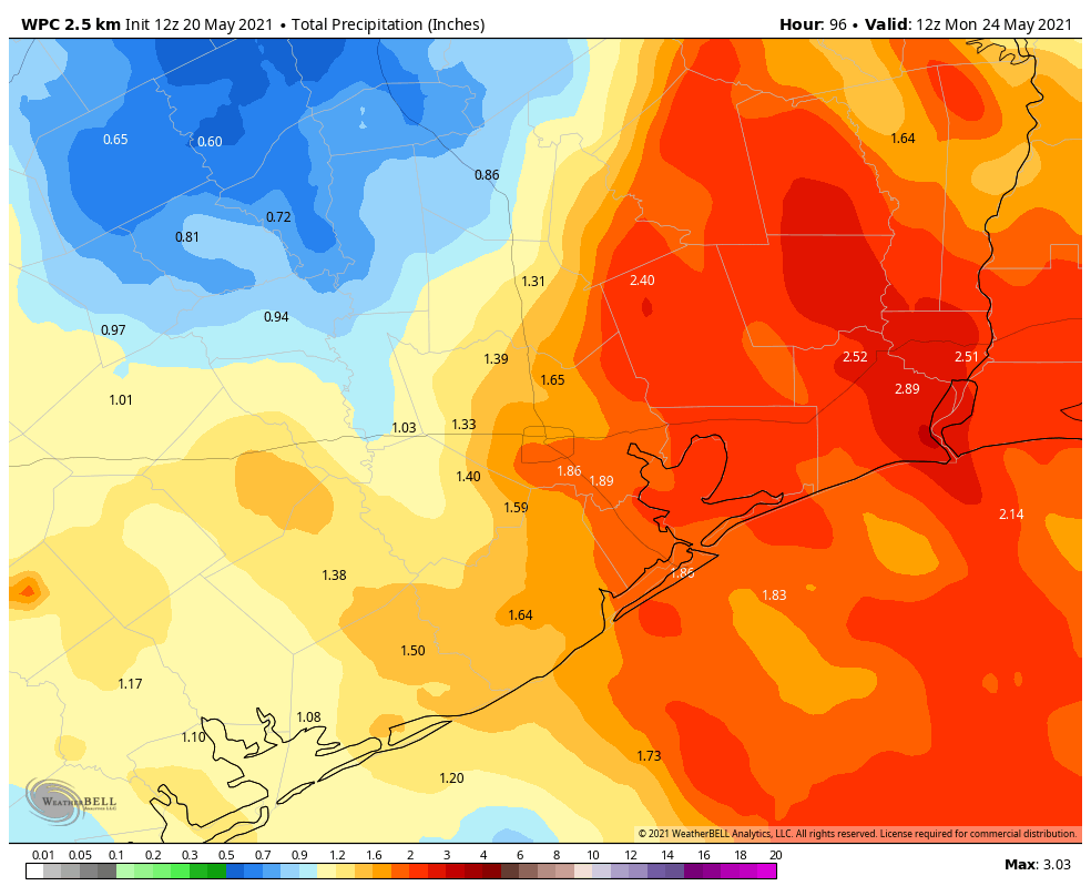
Good morning. The Houston region should see a quiet day today, with scattered showers, before more widespread rain chances return on Friday and Saturday. Overall accumulations, however, should generally remain in the 1 to 4 inch total through Saturday. We therefore are dropping the use of our flood scale as the overall threat diminishes further. It is worth noting that a bit to our east, particularly the Beaumont and Port Arthur areas, could see a bit heavier rainfall this weekend. They were hit much harder earlier this week.
I also want to call attention to a special discussion this afternoon at 3 pm CT, which you can register for here. As part of an event produced by the South Main Alliance, Leroy “Shafe” Shafer, the longtime chief operating officer of the Houston Livestock Show and Rodeo, will interview me. We’ll talk about the origins of Space City Weather, the upcoming hurricane season, and the writing of my book on the early years of SpaceX, Liftoff. The event is free!

Thursday
Our radar is blessedly clear this morning, and we expect only isolated to scattered showers later today. It is possible that the sunshine may peek through for a bit this afternoon or early evening, but skies should remain mostly cloudy. Highs will climb into the low 80s this afternoon, with overnight lows in the low 70s.
Friday
Rainfall should become more widespread beginning early Friday morning, and we’ll see fairly high chances all day. However, these storms should be fairly fast moving, and most areas will likely see less than 1 inch of rain. Highs will be around 80 degrees with mostly cloudy skies. Rain chances will slacken a bit overnight.
Saturday
One final burst of moisture arrives on Saturday, and in the upcoming period this should be the day when our region has its best rain chances. Much of Houston could see around 0.5 to 1.5 inches of rain on Saturday, give or take, with mostly cloudy skies and highs around 80 degrees. This won’t be great for outdoor activities, but at least we do not anticipate any significant flooding from these rains.
Sunday
Rain chances aren’t going to entirely go away on Sunday, but they should drop back quite a bit. We also expect to see at least a modest amount of sunshine during the afternoon hours, although I’m not sure it’s going to get full blown sunny on us. Highs will probably reach the low 80s.
Next week
Skies will turn partly, and then probably mostly sunny next week. This will allow high temperatures to climb into the mid-, or possibly upper-80s by the end of the week. Some slight rain chances will remain each day, but any showers that develop look to be fairly scattered in nature. It’s late May, so you should know better than to inquire about future cold fronts.
Goodness. What a wild system. You and Matt both warned that this was difficult to forecast, based on how it was setting up, but I think it was you, Eric, who said, “along and east of I-45 could see the worst” and that appears to have been the case. I feel so bad for our friends in Louisiana who really bore the brunt of this (along with folks in Beaumont/Port Arthur).
Always see a “cold front” reach the coast around June 1…..not cold, but a wind shift. Just experience at the beach…..
I need to travel through Beaumont/Lake Charles tomorrow to central Louisiana (returning Sunday) — given the flooding situation to our east think the rain on Friday/Saturday will make that not a recommend situation?
I would love an answer to this too as we will be making the same trip.
I’m assuming you should be okay, we’ve had a fair bit of wind, so that should’ve pushed the front out of the Beaumont/ Lake Charles area, but it is possible Louisiana will see some showers, but they aren’t as likely to be as strong as the one’s we saw in the Houston/ Greater Houston area.
I was driving home yesterday from Meridian, MS. Intead of heading sourth to Baton Rouge to pick up I-10, I chose to take I-20 through Shreveport to I-69 at Marshall. I took 69 into Houston. I’m really glad that I made that decision, as there were no issues at all. It added only 40 miles or so to my drive.
Good info. I will remember this option. Thank you.
Any insights on the western part of Galveston from Friday-Sunday??
It should remain fairly clear, although there is a possible chance for some moderate winds, most likely ranging between 10-35 ish mph.
I just saw a major news station reporting what looks like a disturbance in the gulf headed this way over the weekend that’s being watched. Any thoughts on this?