Our old friend SAL, the Saharan Air Layer (dust from the Sahara Desert in Africa) will be making a return visit to Texas this weekend, at least in higher quantities than we’ve seen this week. It will bring some grimy air quality by Sunday, as well as some potentially interesting sunrises and sunsets.
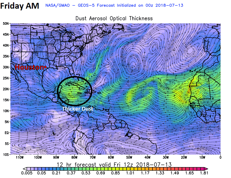
You can see from the animation we’ve put together with NASA data that the brightest colors, or thickest dust arrives on Sunday afternoon, and it should be with us through about Tuesday. Dust has been with us to some extent much of this week, but it will be much more noticeable by later Sunday. So if you are an allergy sufferer (raises hand) or have respiratory ailments, worsening air quality on Sunday and Monday may cause you some discomfort. Air quality should improve after Tuesday. If interested, you can check the Texas air quality outlook here.
Today through Sunday
We’ve had a bit of a late start to thunderstorm activity over Houston the last two days, waiting until 3 PM or later in most cases. Yesterday’s storms were particularly frisky, with parts of Houston’s Inner Loop and West Houston seeing 1-2″ of rain. The Woodlands took home the trophy on Thursday with nearly 3″ of rain in spots.
@NWSHouston An evening thunderstorm dumped 2.44 inches in 64 minutes up in the back of The Woodlands/Alden Bridge. Sorry this photo looks similar to others I have posted but its the only angle from our house where I can take a picture safely. #houwx pic.twitter.com/No9GdzlI5u
— Jeff Royed (@jroyed) July 13, 2018
I’m guessing we will see further hit or miss storms develop today through Sunday. Storm chances will generally diminish each day through the weekend compared to where they have been. Still, a few showers or storms should pop up each morning near the coast (you may have had rain in La Marque or Texas City already this morning, for example), advancing inland during the afternoon. Like yesterday, the handful of places that do see rain could see a fair bit of it in short order, so just be aware of that this weekend.
For most of the area, the majority of the weekend just looks partly to mostly sunny and hot. The last few days saw high temperatures exceed weather model guidance. We’ve hit the mid-90s, despite forecasts generally in the lower 90s. There’s a good chance we’ll do that again this weekend. We’ll call it generally low- to mid-90s for most of the area through Sunday. Overnight lows will be in the middle or upper-70s with humidity.

Next week
In yesterday’s post, Eric mentioned that next week should be the “most summery week” in Houston so far this year. That about sums things up. The large ridge of high pressure that had retreated for a few weeks and opened up Gulf moisture to Texas is going to return with some mid-summer authority.
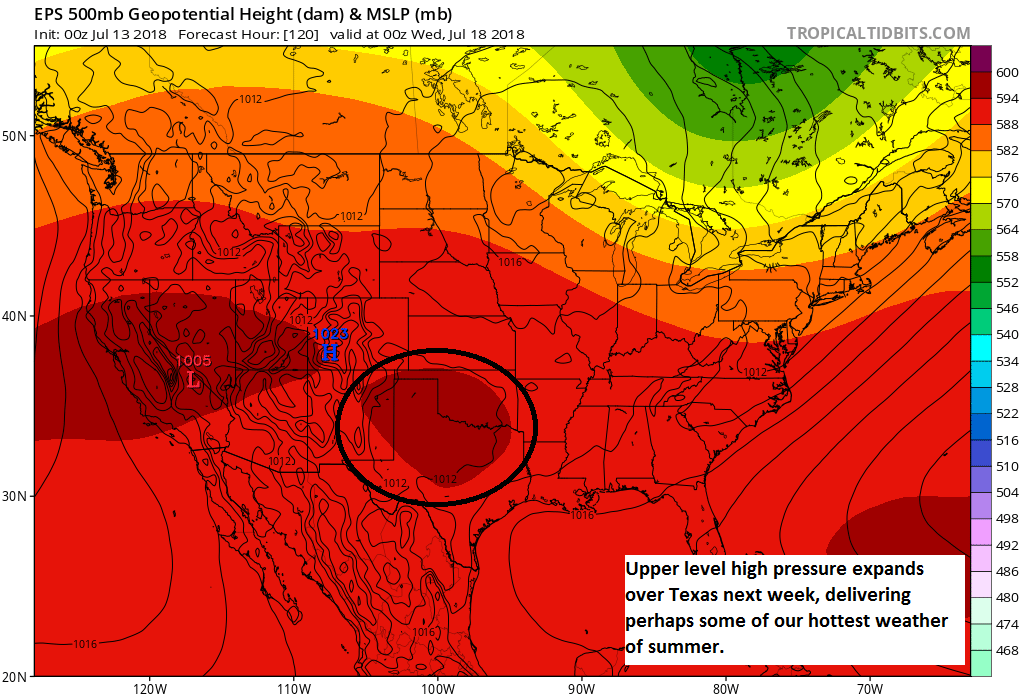
Temperatures should start the week in the mid-90s, but beyond Tuesday, we should begin to see more upper-90s become possible. Nighttime lows won’t provide much relief and should generally stay in the mid- to upper-70s. Peak summer in Houston is the end of July through most of August, and it looks like we’ll be getting our start just a little early this year.
No rain in Cinco Ranch last night. Boo.
It didn’t even make south of I-10. I’m just a few blocks south of the freeway and west of Fry Road in Nottingham Country … I could see the lightning and the stormy skies but not a drop fell here.
It’s crazy how things like that work out. I’m on the north side of 10 just off Fry and we got almost 3/4 inches pretty quick.
I see on both Weather Underground and Weather.com that the TCEQ air quality rating at 6AM was 195, mostly because ozone was high. But shouldn’t ozone dissipate with afternoon vehicle traffic’s dissipation and reduced sun shine and heat? Or was this probably just some data error? What’s going on here?
Thank you for the informations! We will prepare for the heat and plan some nice nights indoors with cold meals! Oh my dear Fulgencio does not like the Saharan dusts! We will have the air purifiers on full powers for sure! Happy weekend and blessings to all!
I will gladly take the Saharan Dust bolowing across us, over the Tropical Storm/Hurricane that “could” be blowing across at us……….
SAL?
Wasn’t that the computer in the movie “2010”?
1:4:9
Better call SAL…
Or call Paul or Paul’s mother. Bet you know them!