Houston had an all-too-brief taste of drier air this weekend, but already humidity levels are rising, and we’re going to see a fairly warm week for early October. Some (perhaps significantly) cooler weather should finally arrive next week.
Monday
As moisture levels rise, we’ll see a chance for scattered showers—with some isolated, heavy rains possible later today, this evening, and during the overnight hours. Most of Houston may just see clouds, but after a sunny, dry weekend the difference in moisture levels will nonetheless be noticeable. Clouds should limit highs to the upper 80s.
Tuesday and Wednesday
Moisture levels will spike on Tuesday, as an easterly flow brings in tropical moisture. Precipitable water levels will rise above 2.0 inches, and this should allow for fairly widespread showers and some thunderstorms. Some of these storms could be pretty heavy, bringing some localized heavy rains. For the most part, I expect people to see 0.5 to 1.5 inch of rainfall, but some areas will see more than this. We are not too concerned about flooding at this time, but will be watching this closely.
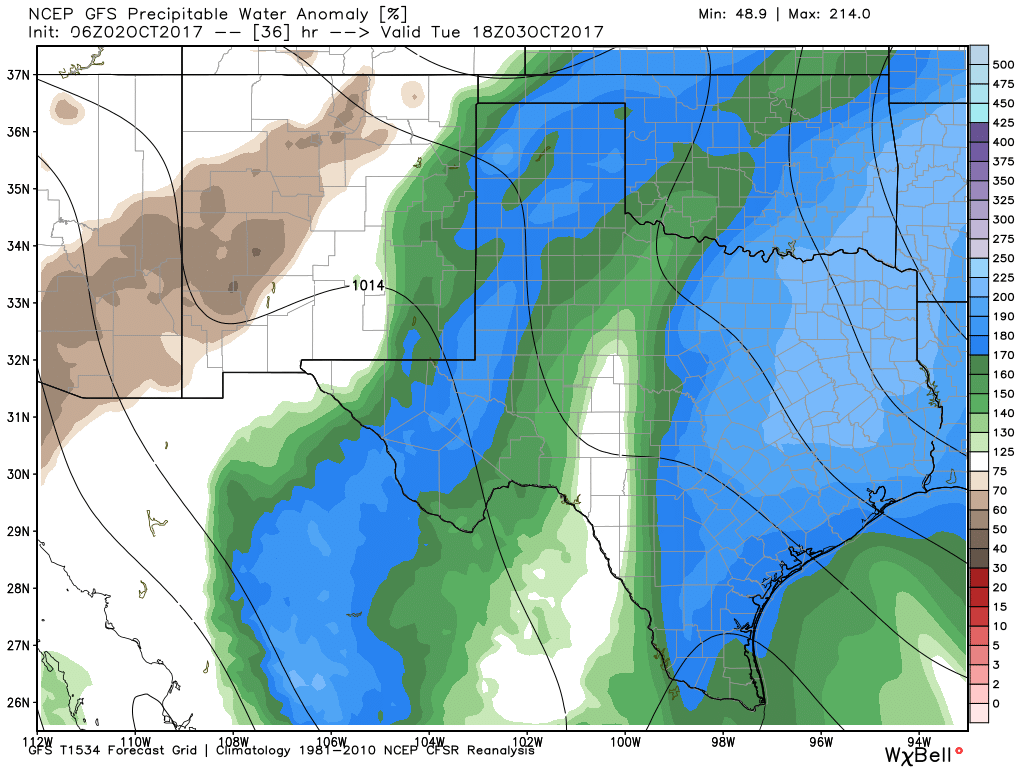
Rain chances will continue from Tuesday night into Wednesday morning, but then should begin to ebb as moisture levels fall, and high pressure builds. Both days should see highs in the mid- to upper-80s.
Thursday through Sunday
The end of this week looks a lot like this past weekend, as drier air begins arriving Thursday or Friday. This should lead to warm, sunny days with highs in the upper 80s, and overnight lows around 70 degrees—cooler inland, and slightly warmer near the coast. But the drier air will feel good, especially during mornings and evenings.
Next week
Both the European and GFS model are now forecasting the arrival of a “real” fall cold front by around next Monday or Tuesday. The European model, in particular, has been highlighting this feature for awhile, and it is showing a pretty strong front with lows falling into the 50s. Dare we dream? I think we do. Fall, for real, is probably coming soon.
Tropics
For the first time in awhile, the Atlantic tropics are quiet. That doesn’t mean the season is over for parts of the United States and Caribbean, however, as the potential for more mischief remains with some very warm water out there.
Last week we told you the Texas hurricane season was pretty much over, and that still looks like it is the case. If the front expected next week arrives on schedule, then the Texas season will be 100 percent over, in our view.
Yahoo! A cold front to punctuate the end of hurricane season locally. That requires a happy jig in celebration!
A cold front to knock out the end of hurricane season locally! That requires a happy jig in celebration!
Thanks for your candid report, Eric. We’re hoping that the hurricane season ends and we can enjoy a relatively calm next 9 months 🙂
Eric, what do you think about the mexico/central american gyre that the weather channel is showing? Do you anticipate any of Texas affected or is it too early to tell? Or will the cold front moving in next week help to stave off potential problems?
Thank you Eric. You have no idea how your calming words have gotten my through the last month. When is your fundraiser again???
We have to get ur stuff together. Have a facebook group for fans and go from there