After a chaotic week of weather, Houston will face gradually face somewhat more benign conditions as we head through the weekend. First, we have to get through the potential for showers & storms today and possibly Saturday. That will be followed by quite a breezy day on Sunday.
Today & Saturday
Fog this morning is pretty dense over most of the region, and dense fog advisories are posted basically along and south of Highway 105. Use a lot of caution out there this morning.
The fog will lift later this morning, so we should see a little sunshine. Clouds sneak back in this afternoon. The big question then becomes where showers or storms develop. I want to show you two pieces of data that we’re looking at. This is a forecast radar for 6 PM this evening. The HRRR model is on the left, and a model run by Texas Tech is on the right. Click to enlarge.
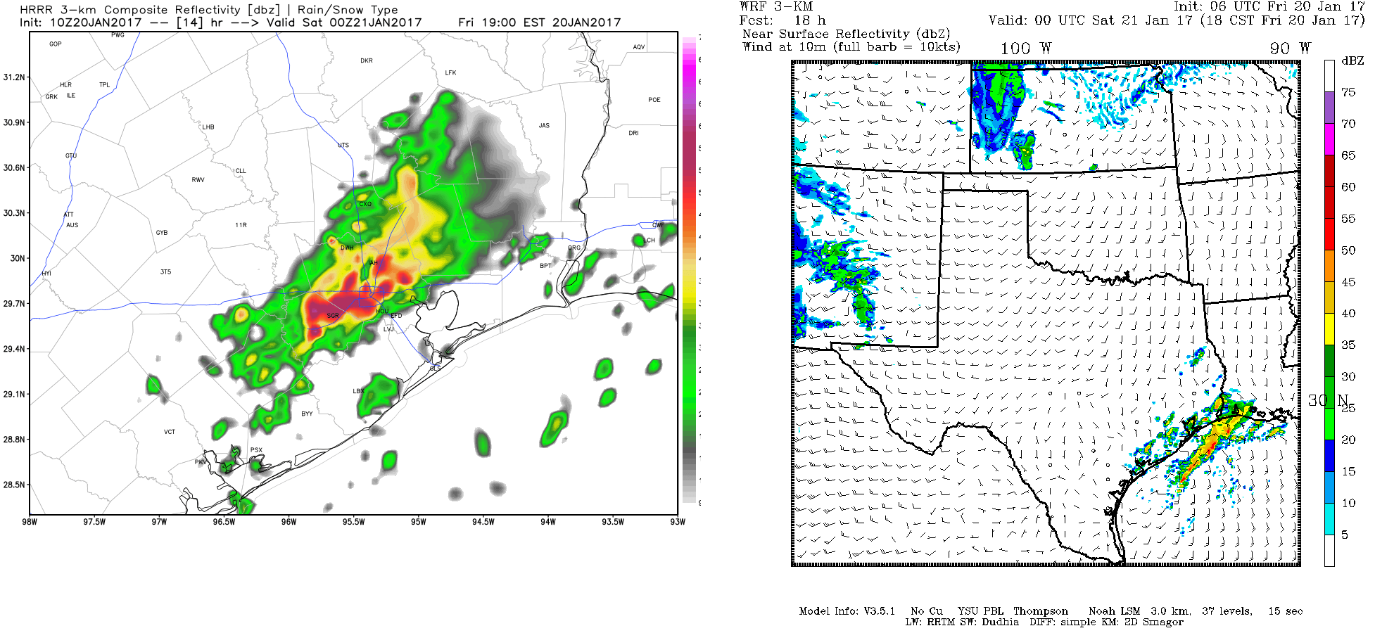
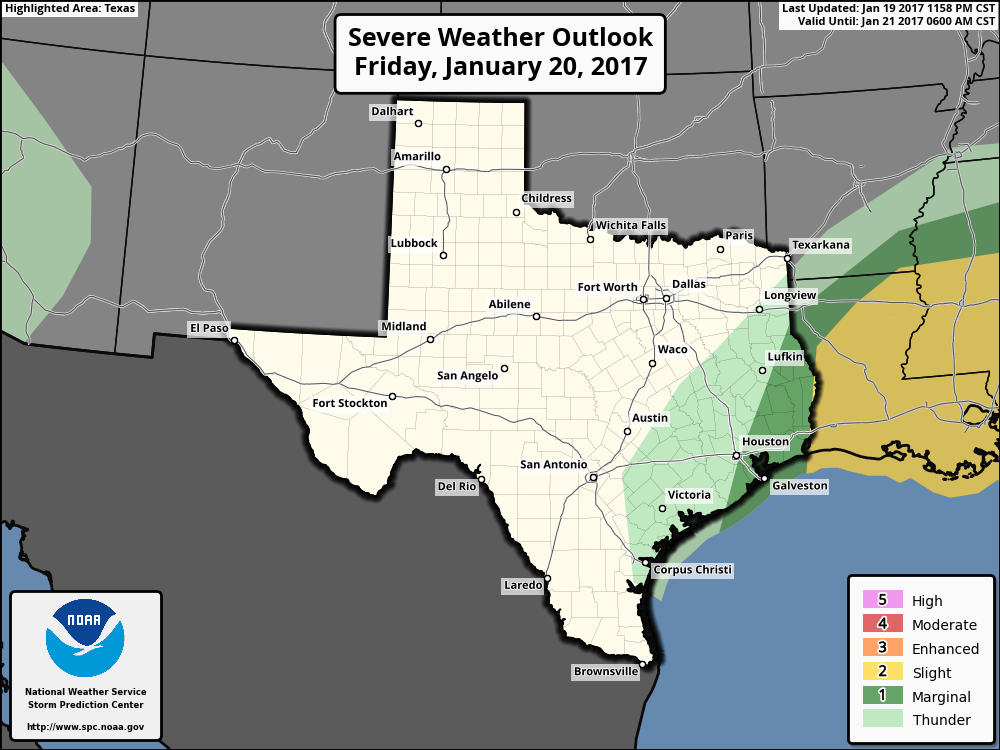
The HRRR (left) indicates the warm front in the Gulf may get all the way to I-10, helping to fire up thunderstorms this evening. The WRF (right) has the front falling just short and keeps most storms near the coast or over the Gulf. Given the uncertainty, the SPC has the eastern part of the region in a “marginal” risk for severe thunderstorms.
My feeling is that the HRRR may be overdoing things a bit, but it’s a close call. I am apt to prefer this SPC map and say the best chance for storms remains south and east of Houston later today. We will update you if that changes, but definitely have an umbrella handy today to be safe.
On Saturday, it actually looks fairly quiet. With a strong system developing to our northwest, we could see a few showers or storms, but any legitimate severe weather risk looks to stay well east of the Houston area, in Louisiana. Temps will peak in the mid 70s both days, with lows in the low 60s tonight.
(Space City Weather is sponsored by Westbury Christian School for this month)
Sunday
This storm developing to our north will drag a cool front through the region early Sunday morning, ushering in *much* drier air and strong winds. A lot of talk starting about this. It will notably breezy Sunday morning and afternoon. Inland areas should see sustained winds of 20-25 mph, with gusts to 35 mph perhaps. Some locally stronger winds are possible toward Wharton, Bay City, and Victoria. At the coast, we’ll see stronger winds, gusting at times to 35-40 mph (perhaps 40-45 mph offshore). If your Sunday plans include a boat, there is a Gale Watch already posted, with Gale Warnings likely to follow.
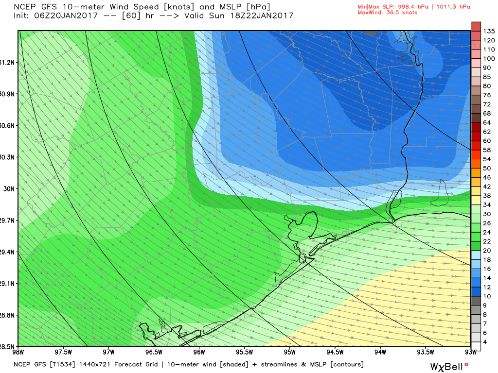
Does this mean widespread power outages? No, I really don’t think so. Whenever you have breezy weather like this, you can have a few minor issues, but it’s nothing I’d be worried about. Other than the wind, Sunday looks dry and pleasant, with high temps in the mid to upper 60s. Sunday night’s low temp still looks to dip into the 40s for the first time in a couple weeks.
Next Week
The weather pattern will begin to evolve from a warm dominated one over Texas to a cool dominated one. We’ll see a cold front move through probably on Wednesday, likely without much fanfare, just some wind again. Temps will warm from the upper 60s or low 70s Monday to the upper 70s Tuesday. Behind the front, we’ll see high temperatures cool back to near where they should be this time of year. We’ll have high temperatures in the low to mid 60s or even upper 50s in the back half of next week, and we should see several days in a row with low temperatures in the 30s and/or 40s. It should certainly feel more like Texas winter.
Posted at 6:45 AM by Matt
Looks like the SPC has updated the severe outlook map, expanding the slight risk area to cover a good chunk of the area. Hail and wind appear to be the biggest threats, but there is still a non-zero risk of a tornado.
Odd question: I’m struck by how often over the years that I-10 gets mentioned as the boundary for this or that weather system. Is this purely a convenient and familiar way to demarcate the city? Or is there some subtle topological or geographical or some other type of change that happens along this route? (P.S. To Eric, I really enjoy your writing at Ars Technica.)
Purely convenient. US 59 sometimes serves a similar purpose, as does I-45 when there is an east-west gradient.
(And thanks! Love working for Ars.)
Looks like the model this morning was spot on. Can you post a comparison of the model and the actual radar at 6:00pm?