Good morning, and happy birthday America! It’s a damp one for many of us this morning, though I imagine some others are asking if it will ever rain at their homes. Let’s walk through the forecast.
Now & this morning
As of 8:15 AM, radar shows pockets of heavy rain and thunderstorms gradually pivoting toward Houston from the east. Areas west of the city have seen little rain since yesterday. Eventually some of this will indeed get there.
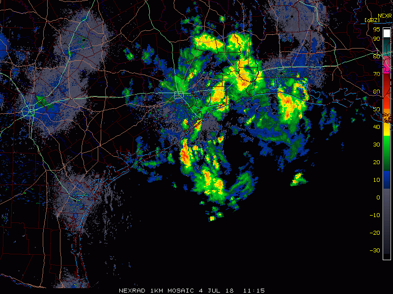
So through about midday, expect rain to become more frequent in the area. The heaviest will continue to hug the coast south and east of Houston.
Rain totals to this point have been manageable, though there has been almost 1.5″ of rain in the last hour along Vince Bayou in Pasadena. An urban flood advisory is posted for southeast Harris, Galveston, Chambers, and eastern Brazoria Counties until 11:45 AM, meaning street flooding is likely in spots.

As rain slowly winds through the area this morning, be prepared for more pockets of localized street flooding in areas of poor drainage, along frontage roads, etc., especially south and east of Houston, where it has rained more and is raining harder. We aren’t expect anything too significant today, but be aware of street flooding potential and never drive through a flooded road. We’ll keep you posted if things escalate.
Timing the end of the rain
So expect periods of showers, heavy rain, and thunderstorms for much of this morning and early afternoon, especially southeast of Houston. When does it end? Model guidance has slowed things down a bit unfortunately. The good news is that the heaviest, most concentrated rains should be west of the area by about 2-4 PM. There will be isolated, hit or miss downpours still around the region however through 6-8 PM. I still think most evening events should go off without a ton of issues, but you may want to include an umbrella (assuming that’s allowed at your event) with your other items if you’ll be out and about.
Rain summary
So just to sum things up:
- Heaviest rains south and east of Houston this morning, with rain rates of 1-3″ per hour possible at times.
- Rains will expand north and west and everyone should get at least some rain.
- Localized street flooding is likely in spots, again mainly south and east of Houston.
- The steadiest rain should taper off this afternoon, but scattered showers will remain in spots (not everywhere) through early evening.

Thursday into the weekend
Onshore flow will continue each day through the weekend. Add to that, ample moisture and a couple disturbances, and you have a recipe for scattered showers and thunderstorms each day. There will be varying amounts of coverage and intensities through Sunday, but I think most places will see at least some additional rainfall through the weekend. I’d expect an average of another half-inch in most of the region, but a few spots will likely see 1-3″ through Sunday, if not a bit more. I still expect the stormy pattern to ease up a bit later next week.
Clouds, showers, and storms will keep temperatures in check in the area. Daytime highs will average in the upper 80s to lower 90s, and look for nighttime lows in the mid-70s; a little bit better than we’ve seen for most of the last two months.
Thanks Matt and Happy Fourth to you too!
That total rainfall map can’t be right can it? I was driving east on Westpark/59 from Fondren to Weslayan last night and there was a huge downpour for about 10 solid minutes… Map makes it look like 0.00 or 0.04″ at the most accumulated in the area which can’t be right
You can get an up-to-the-minute map here:
https://www.harriscountyfws.org/
Tim, since those maps don’t cover every single location (and you know how rain works here, where one side of the street gets wet and the other doesn’t), there will definitely be some imperfections, shall we say? I’m fairly sure some folks out there could have gotten 0.25-0.5″ or so based on what I saw on radar last night!
Can you tell us the wind rates experienced last night in Kemah and future wind expected? We had damage last night on the coast.
I didn’t happen to look at Kemah on the weather.gov site last night, but I’m in Clear Lake area and it said we got 26 mph winds with 46 mph gusts. Sounds like you got some of that.
Ellington Field gusted to 46 mph. Along the coast, I imagine you could have hit 50-60 mph. There were a handful of wind reports there: https://forecast.weather.gov/product.php?site=hgx&product=LSR&issuedby=hgx
I knew I was in trouble just before 8:30 when the landscape lighting came on. About five minutes later it started pouring.
A quick dash out to the rain gauge shows 3.4″ in 50 minutes!
10 am and streets near Buffalo Bayou are flooding. Do you anticipate this will taper off soon?
We’ve had 1.43″ in Champions this morning as of 10:13AM. Still coming down but at a very modest rate. Cypress Creek has not budged from its usual summer lows.
We’re up to 2.96″ in Champions as of 11:10AM. Cypress Creek has risen about a foot, which means it’s still really low.
The rain seems parked over Houston, moving very slowly west. I like this radar view:
http://www.corad.org/ridge/khgx.php
In Montrose we’re seeing some significant street flooding. All the water meter covers are starting their migration to the gulf.
Your comment made me lol!
Happy Fourth of July!
Rain in July in south Texas always makes me happy!
Admittedly, an old topic, but what is the situation with the Saharan dust? Will this rain wash it out of the air or has it moved out of the area?
Saharan dust from this weekend’s event was mostly gone on Monday. Anything left has been eradicated today.
It’s noon, I’m in West U, have had 10″ of rain since 8:30 am.
Does anyone know how to find out if Miller fireworks get cancelled?
I study three different weather apps – Weather Underground, Weather Bug and The Weather Channel. I realize there are many to choose from, but those three, coupled with what I get from the local news teams and Space City Weather, I am able to pretty much figure out whether or not I should go anywhere. Weather Underground provides accumulation and maps (updated about every 15 minutes as patterns fluctuate), Weather Bug maps and lightning and Weather Channel has a decent “future track” map. Local weather, at times, confirms what I come up with, or winds up somewhat flat out wrong.
What I’m getting at is this – use your apps available to you and perhaps make better judgement calls for your safety. I chose to just stay home – always a good idea when systems like these come around.
Can we talk about the weekend yet? We moved our celebration to Saturday anticipating clear skies!