The bulk of the region’s children may return to school this week, but weatherwise Houston will remain in full-on summer, with the potential for an additional 100-degree day or two during the midweek. A bit of drier air will help keep relative humidity down just a touch, which will help with the daytime heat index—a little bit.
Monday
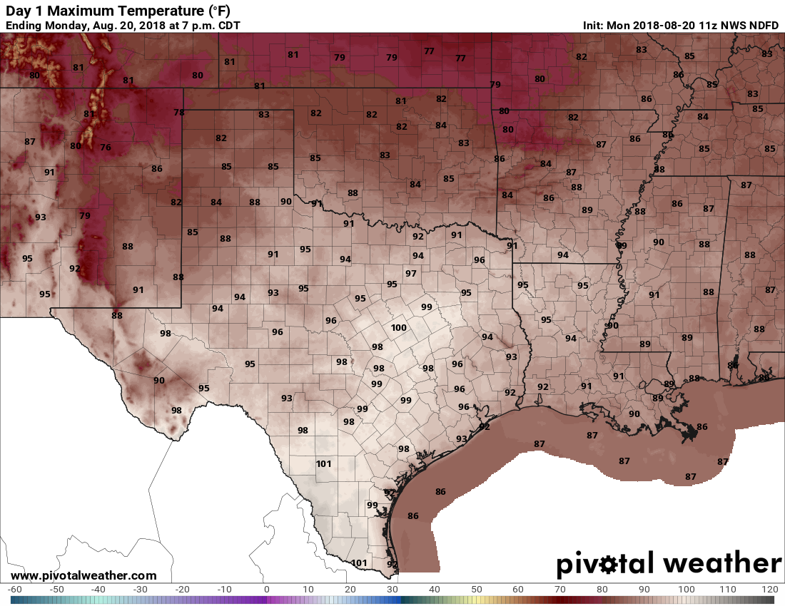
Monday will probably see a continuation of the weather we saw this past weekend, with high temperatures in the mid- to upper-90s, partly sunny skies, and a slight chance of showers and thunderstorms.
Tuesday
Yes, that cold front we mentioned last week has progressed toward Texas, and on Tuesday the remnants of it will slowly limp into the greater Houston region. Don’t expect much (any, really) cooling, but the front will be the impetus for some rising air on Tuesday, and some slightly better rain chances. I suspect about 40 percent of the area will see some form of showers, ranging from sprinkles to about half an inch of rain, beginning early Tuesday and running throughout the day. Highs in the mid- to upper-90s.

Wednesday, Thursday, and Friday
In addition to bumping up rain chances Tuesday, the front should eventually bring a few puffs of drier air into the region as well. This will allow daytime temperatures to heat up a little more quickly during the second half of the week under sunny skies, so we should see highs ranging from 95 to 100 degrees across the area. Overnight lows will be in the upper 70s. This is classic August weather as high pressure dominates overhead.
Saturday and Sunday
Fortunately, at least as of right now, high pressure seems unlikely to remain entrenched for a long time. Forecast models suggest it will back off somewhat this weekend, pushing high temperatures back down into the mid-90s, and allowing for a slight (20 to 30 percent, probably) chance of rain to return to the forecast. As of now, Saturday looks a little sunnier than Sunday, but forecast confidence remains somewhat low.
Bleahhh!
I always take vacation in late August. I am sooooo sick of summer, so headed to Quebec for a week. Laissez les bon temps rouler!
Me too! I’m in Jackson Hole right now. 😆
Remember a year ago this coming weekend? I hate the heat, but versus the alternative, I’ll take it all day, every day.
Sure do! Beginning tomorrow I’m going to post a snippet of our updates from a year ago, “on this date.”
Thank you, I think that should be very interesting and remind people that others are still rebuilding, and Harris County of what needs to be “fixed.”
Any outlook on the tropics for the next 6 weeks? Hoping the high shear continues to dominate…
Still quiet for now, but we’ll definitely see some activity over the next month as we reach the peak of the Atlantic season. Will any of it get into the Gulf? Hope not.
Thanks for always providing us with our weather reports! Here’s the big question…..when are we going to see star me fall temperatures this year!!!!!!
Hopefully in about three or four weeks we’ll get our first taste of fall.
Is there that big of a difference between 30 percent and 40 percent rain chances?
Fire the cold front!
A solar eclipse and carastrophic hurricane in the same week. A week we will never forget. Is there any correlation between the two events?