A cold front pushed through the region Tuesday night, and this should give us a brief bit of drier air and sunshine today before clouds and intermittent light rain return for the rest of the week. The next nice day should come Sunday before rain chances return on—you guessed it—Monday.
Wednesday
It’s chilly this morning, with lows in the mid-40s, and cloudy skies. However, as drier air moves in from the west we’ll see some clearing skies and this afternoon should be pretty nice with partly to mostly sunny skies, and highs in the mid-60s. This should last about through this evening as high pressure exits to the east, and low pressure returns. This will lead to an influx of moisture, clouds and rising rain chances tonight.
Thursday
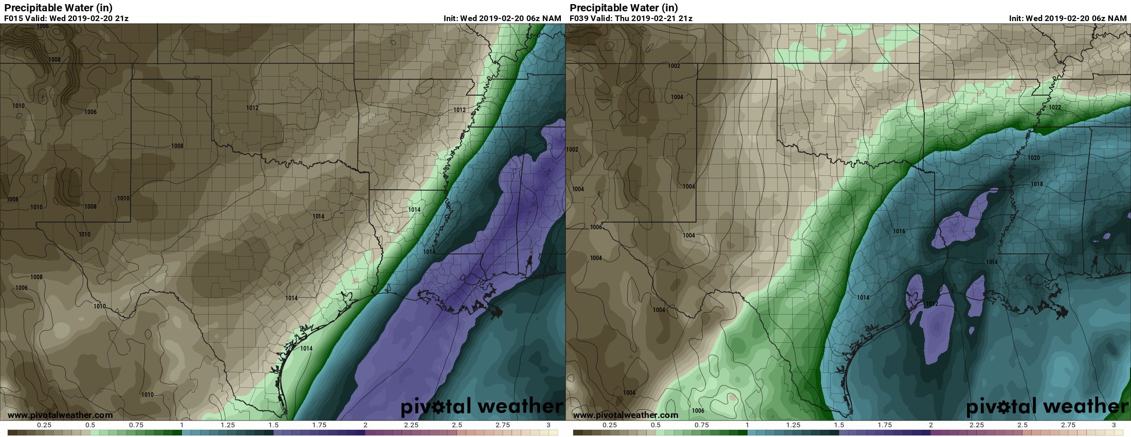
As the image above shows, moisture will return rapidly, with drier air Wednesday giving way to moisture return from the Gulf of Mexico by Thursday. Showers and a few thunderstorms will be possible Thursday across the region, but for most accumulations should be a few tenths of an inch of rain, or less. Highs will be around 60 under leaden skies.

Friday and Saturday
Our weather will warm heading into the weekend, with highs generally in the mid-70s, and lows on Friday night perhaps only falling to around 70 degrees under a thick blanket of clouds. The intermittently wet weather should continue through most of Saturday, but again, accumulations should be modest with mostly light rain and possibly a few thunderstorms. A cold front should arrive around midday Saturday, which will bring some cooler air in that evening, and finally begin clearing our skies for Sunday.
Sunday
This continues to look like a winner for any and all outdoor activities this weekend. We’re still looking at mostly sunny skies in the wake of Saturday’s front, with dry air, and winds look light. I’m excited for this day, especially as it falls on a weekend.
Monday and beyond
Alas, in this period in which we seem to get one nice day and then several cloudy ones, Monday probably will see the return of clouds and rain chances. Monday looks fairly cool and gray, with highs perhaps around 60, before a warming trend by Tuesday or so. Then another cold front looks set to arrive, and we’ll probably repeat this pattern all over again.
Masters track meet in College Station on Sunday – the only nice day out of all of this. Nice to catch a break.
Sunshine? “Sunny skies”? Please explain these concepts. Thanks.
Do you think we have dodged a freeze along the ship channel in Deer Park this year? Would like to set out a few things in the garden by the first part of March. Hold off or go for it? Just your opinion….I won’t Hold you to it.
Yes, I would feel reasonably confident that Deer Park won’t see a freeze again this winter. An 80 percent chance, at least, I’d estimate.
Thank you so much for responding!
Eric, is it me, or has this winter been cloudier and rainier than what is typical for Houston?
I can’t remember a time with such little sunshine in the winter since i moved here.
Both this February and last February were incredibly gray. This winter is more or less typical of weak El Nino conditions.
Where in the ENSO cycle do we need to be to get cloudy and cool in July/August? 🙂
Wisconsin
To be fair, some of us like cloudy weather. We’re in the minority, I grant you.
We really don’t have it bad at all. It’s beautiful today! I think parts of Tennessee have not seen any sun at all in 2019.