Coastal fog is driving down visibilities this morning, and we’re going to have one more day in this warm, soupy weather before a cold front clears things out and brings several days of fine sunshine to the region. We’re monitoring today and tonight for the possibility of storms, but again we think the worst of this system will likely pass mostly north of the metro area.
Wednesday
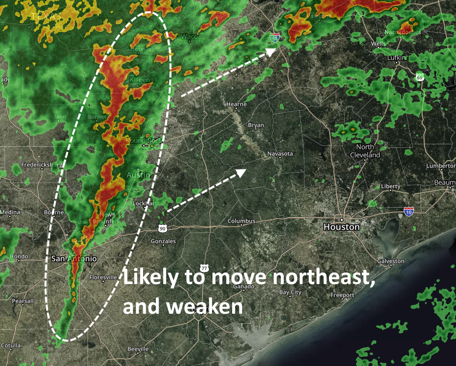
There’s a pretty strong line of thunderstorms shown on the radar image above, but the models suggest a movement that should keep most, if not all of the stronger thunderstorms north of the Houston region, including Montgomery County. As a result, we expect today to be a cloudy day, with a good chance of rainfall lingering into the evening hours. I’d expect accumulations of perhaps one-half inch or more (if you’re unlucky enough to get hit by one of the few thunderstorms) north of Interstate 10, with less closer to the coast. Highs will reach near 80 degrees before a front slowly moves in to drop temperatures in the 50s overnight.
For the rodeo this evening, we expect rain chances to fall off around sunset, so while we can’t guarantee dry weather, more likely than not there won’t be too many rain drops. Temperatures will drop into the upper 60s this evening, with light winds. The stronger winds associated with the front probably won’t arrive until after midnight.
Thursday
Skies should become partly to mostly sunny some time on Thursday morning, with the potential for gusts of around 20mph. These winds should die down a bit later in the day, with high temperatures probably pushing up to around 70 degrees.

Friday
This should be a splendid day, starting out with temperatures of around 50 degrees in the city, and warming to 70 degrees under partly to mostly sunny skies. Winds will be light on a day that should represent the best of spring in Houston. Friday night looks like the coldest night of the next week, with temperatures dropping into the upper 40s for parts of the region.
Saturday
This should be a nice spring day, with a mix of sunshine and clouds, and high temperatures reaching about 70 degrees. Lows Saturday night will be a touch warmer as the onshore flow resumes.
Sunday
Despite the resumption of the onshore flow, Sunday still looks seasonably pleasant, with a high temperature of around 70 degrees and some stretches of partly sunny skies amidst the clouds. Lows by Sunday night will only fall into the 60s, most likely.
Next week
Some rain chances return late Sunday or Monday, but we’re not seeing anything too heavy in terms of accumulations. Some kind of front may work its way through the region on Tuesday, but I’m far from guaranteeing that.
Last time to see <50 deg Fri night/Sat morn?
As the Chicago Cubs faithfuls say after the first game of the year…”just wait till next year!!”. I’m learning the same applies to rain chances around here. My current thinking is which happens first…we get decent rain here or we get quarantined for the corona virus.🤯
As a Mariners’ fan, I tend to say “will we ever…” 🙁