Summary: After mild conditions today we’re looking ahead to the possibility of widespread showers and the potential for thunderstorms on Thursday. Following that, the weekend looks exceptional, especially Saturday. Also, in today’s post, we note that the upcoming Atlantic hurricane season is likely to be a busy one.
Looking ahead to hurricane season
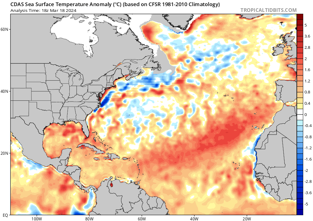
Before jumping into the forecast for this week, I want to look ahead to the coming Atlantic hurricane season. It formally begins in a little more than two months, on June 1. For the full rundown, I want to point you to our companion site, The Eyewall, where Matt has gone in depth. But the long and short of it is this: It’s becoming increasingly difficult to objectively look at things without concluding that the upcoming hurricane season could be a very active one. Here are some key takeaway messages:
- El Niño continues to slowly erode away in the Equatorial Pacific.
- La Niña development continues to look plausible, if not likely by August or September, a feather in the cap of an active hurricane season forecast.
- Atlantic Ocean sea-surface temperatures remain excessively warm virtually everywhere that matters.
- We are likely to see some very active hurricane season forecasts get released in the coming weeks.
By no means does an active, or even a hyper-active, Atlantic hurricane season mean that the upper Texas coast will be impacted this summer. It just raises the likelihood of this occurring. We’ll have more information for you on preparedness measures to take in the coming weeks.
Wednesday
It’s a mild morning, with temperatures generally in the mid- to upper-50s. We’ll see a bit of sunshine, but for the most part skies this afternoon will be mostly cloudy, and this will help to limit highs to around 70 degrees. Although we’re now under the influence of a southerly flow, we’ll still see some fairly dry air in place today, so humidity will be fairly low. Winds will be out of the southeast at 5 to 10 mph. Some very light, very scattered showers are possible this afternoon and evening, but for the most part I expect these to hold off until Thursday. Lows tonight will drop into the low 60s.
Thursday
Here comes the rain. With the approach of low pressure in the Gulf of Mexico, we’ll see an increasing amount of moisture in the atmosphere. Some time on Thursday morning, probably (but not certainly) before sunrise, we’ll start to see development of scattered showers and thunderstorms. These will likely become more widespread after sunrise and through the morning hours. We may see a bit of a reprieve during the late afternoon and early evening hours, but a final round of storms could push through late Thursday evening or during the overnight hours. The primary threats from this system are heavy rainfall, with accumulations of 1 to 3 inches possible, and hail.
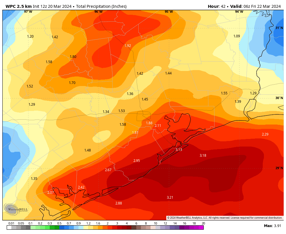
Highs on Thursday will reach about 70 degrees, with easterly winds. Lows on Thursday night will drop to around 60 degrees.
Friday
We’ll see a northwesterly flow on Friday in the wake of Thursday’s storms, and this should allow for clearing skies. With more sunshine, expect highs to push into the mid- to upper-70s. As a bit of drier air moves in, look for lows on Friday night to drop into the 50s, and possibly the low 50s for areas further inland.
Saturday and Sunday
The weekend looks fine for outdoor activities—especially Saturday. We’ll see plenty of sunshine, light winds, and dry air. Look for highs in the upper 70s. Really, could you ask for more? Sunday will still see a bit of sunshine, but we’re going to see the onshore flow returning, and I expect we’ll see some gusty southerly winds at 20 or 25 mph and increasing cloud cover. Highs will again be in the upper 70s, probably.
Next week
We’ll see some rain chances on Monday, and possibly another chance at storms, with the passage of a cold front. This will set the stage for a pleasant week with highs in the 70s and low in the 50s. Seriously, this is peak spring in Houston, and I am here for it.

The only word that made me pause was in the Thursday forecast – and it is the last word: “hail”.
The last word in the Thursday forecast is “degrees”. “Highs on Thursday will reach about 70 degrees, with easterly winds. Lows on Thursday night will drop to around 60 degrees.” — Space City Weather
1!:~D}
El Niño is going away? I thought it just got here after like 2 years of La Niña. Hope that doesn’t mean another drought and relentless killer heat like last year.
Great time to start assembling a list and creating a budget for hurricane prep, especially big items like generators.
Anyone have recommendations for a good battery-powered radio? I’m not sure what to trust.
Hi Mueschke 😊
try a NOAA weather alert radio… with various ports, little features that you might like 📻
tip: play w it before you need it, and find the NOAA frequency for Houston: around 162.400: fiddle w it till it’s clear 🔋 I’ve marked mine with a thin black line to the exact spot where I need to tune in, so I don’t have to search for it when I’m trying to get information 😉
We didn’t get much rain last weekend up here in the Champions area. We could use a good inch or so to wash all this pollen away, so I’m hopeful for Thursday.
Didn’t we just have 3 years in a row of La Nina? We only get barley one year of El Nino and we are already fixing to be thrown back into another 1 or 2 years of La Nina! I thought Ocean Temperatures were supposed to be warming everywhere not cooling. Hopefully we get alot of rain this summer because we will be heading right back to droughtvile this fall and next year.
When showing the SST Anomalies, why is the period of 1981-2010 used? Discounting the last 13 years of temperatures would seem to skew results, especially since temperatures have been warmer in that period. I understand the 30 year range as it relates to climate vs weather, but why not use 1994-2023 as the basis for the anomaly? That would seem to give a better basis for comparison to recent seasons.
Thank you.
Good question. The new normals have been out since 2021. Tropical Tidbits has not updated. Anyway, I took a long at the world view on TT and it seems La Niña is already here. At least based on SSTs. But I’ve been told over and over on this site (Joseph?) that La Niña does not necessarily bring dry summers. More tropical stuff (weather from the Gulf) is what’s needed to get summer rain and that’s what we want. And no warm air influx from the Alto Plano at 5000 feet – that’s bad.
That is correct. The summer can go either way regardless of the ESNO. We feel the effects of La Nina more during the cool season. Even then it is not a guarantee.