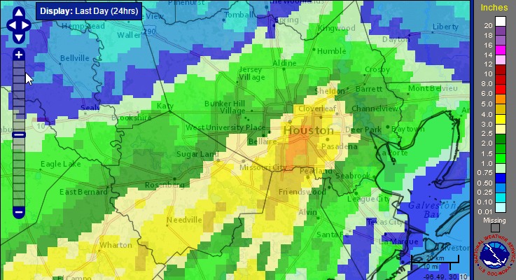
Obviously, the big story this weekend was heavier than anticipated rainfall on Sunday. Our Friday forecast for the weekend was not particularly good. We missed on the potential for heavy rainfall and storms on Sunday, when some areas of southern Harris County recorded as much as 6 inches of rain. While there were no major flooding events as a result of the rain, and most of the region received 1.5 inches of rain or less, it is nonetheless regretful. It also serves as a reminder of the challenges of predicting heavy rainfall along the Gulf of Mexico.
Monday
It’s another very warm morning for early spring, with low temperatures only falling to around 70 degrees for most of the Houston area. After Sunday’s widespread showers, moisture levels remain fairly high over the region, but there’s not the same forcing to really drive the development of rain. As a result I think we’ll see some scattered rain showers later this morning and afternoon, but nothing too widespread. Highs will be around 80.
(Space City Weather is sponsored this month by an anonymous donor)
Tuesday
After another warm morning look for rain chances to increase ahead of a cold front that will reach the Houston area sometime during the day, perhaps during the early afternoon hours. Best guess is that most areas receive 0.5 to 1.0 inch of rain during the the day, before rain showers and storms end later Tuesday afternoon or evening with the front’s passage. Some moderately strong thunderstorms are possible with the front, although the chance for severe weather is higher to the northeast of the Houston metro area.
Wednesday
We’ll be a little bit cooler Wednesday morning thanks to the front, with low temperatures falling into the mid-50s for areas well inland, and closer to 60 degrees along the coast. But the front just won’t have that much oomph. Highs on Wednesday should climb into the low 70s, with a slight chance of rain later in the afternoon.
Thursday through Saturday
After the onshore flow resumes later on Wednesday, we’re going to fall into a pattern of warm spring days, with highs in the upper 70s, partly to mostly cloudy skies, and the chance for a few showers and thunderstorms. I don’t expect rainfall amounts during the second half of the week to be too significant, or any kind of major storms, but it doesn’t seem like we’re going to see a whole lot of sunshine after Wednesday. Another weak front arrives later on Saturday or Sunday.
Posted at 6:50am CT on Monday by Eric
Meh, don’t sweat it. I got 2 inches over 12 hours here. Picture perfect day of rain imo.
Thank you to the ANONYMOUS DONOR !!
I’m guessing that the storm training we saw yesterday is not easy to forecast.
I’ll step in and reply here…and say yes. Situations like yesterday are very difficult. I think the end-game explanation is just that the system traveled about 50-75 miles further northwest than it was supposed to, and that did it, but all that aside, trying to predict storm training is difficult even when the storm is well forecast. You can make some assumptions, but how it exactly unfolds is very difficult to peg down more than a few hours ahead of time.