Good evening. We’re getting closer to the first of two rounds of potentially heavy rainfall for the Houston area, and we’ve seen enough data from the high resolution models to raise our concerns. Therefore we’re issuing a Stage 1 flood alert for the greater Houston region. Such a Flood Scale alert, effectively, means to expect the potential for street flooding in the Houston area.

The first period of heavy rainfall will begin after midnight tonight across the Houston area, and the atmosphere is moist enough to produce rainfall rates of 1 to 2 inches per hour, which can begin to back up roadways. Conditions for heavy rainfall will persist into the morning hours on Friday, and possibly into the early afternoon. Our general expectation for rainfall totals during this first round is 1 to 2 inches for most areas, but there will very likely be some bullseyes that receive up to 5 inches or more.
Then we expect to see something of a lull in rainfall from Friday evening into Saturday morning, before round two begins. Storms will probably get spun back up from Saturday afternoon through Sunday morning, when there may be another 1 to 2 inches of widespread rainfall, with more bullseyes. This is all being driven by a slow-moving upper-level low pressure system that is difficult to predict.
We’ve issued this Flood Scale alert tonight, because we think some areas may see heavy rainfall before sunrise on Friday morning. Matt will have a full update for you early on Friday, and will reevaluate our Flood Scale status at that time. Then, of course, we’ll keep tabs on this system over the weekend as needed.
Well, we need the H2O.
My lawn and garden will be happy
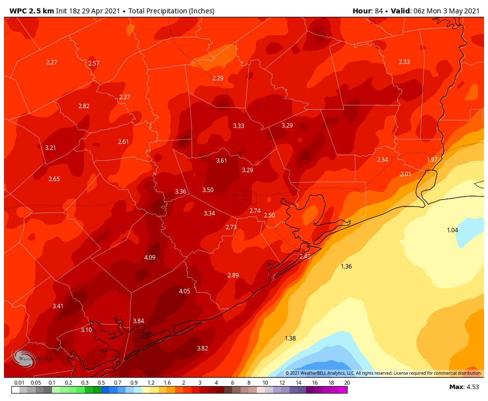
On these maps, would it be possible to label the counties? HR for Harris or GA for Galveston, at least one county can be labeled so we can get an idea of where the other counties are located. I check the coastline for Galveston Island, and I think I found it, but Matagorda is also with an island, so I can get a little confused. People new to the area probably get really confused.
Looks like the West End is going to get more than the East End, but still around 3”, if I’m looking at it correctly.
The county lines are drawn on the map above, but they are pretty faint. They just aren’t labeled. If you are in the Houston area, it might be more useful to use the highways and the 610 loop to pinpoint your location on the map.
The 610 loop is always shown to orient you.
Chances of hail?
Would this cause school closures? There’s nothing in the rumor mill…
Can’t imagine any reason why it would. It’s just a normal Houston spring rain dump.