Good morning, everyone. We interrupt your Sunday with a short post on the threat posed by severe weather today. Strong thunderstorms are possible in Houston this morning and during the early afternoon hours ahead of a cold front.
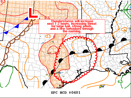
Several favorable dynamics in the atmosphere—including an eroding capping inversion—should combine to allow organized storms to form along a eastward-moving system that will push through Houston between around 9am and 3pm today. Large hail, damaging winds, and a few tornadoes are possible. It is likely that a tornado “watch” will be issued for the area.
Note that this is not a classic line of storms, and some locations could see more than one round of severe weather. Rainfall accumulations will vary widely, but we do not expect widespread flooding issues. Not everyone will see severe weather, and chances are probably a little bit better north of Interstate 10, but please do be weather aware today.
In the wake of the front tonight, expect clearing skies and lows in the 60s. Monday and Tuesday should be pleasant, sunny days with a chance of storms returning Wednesday.

Where can one go to find out if Houston is under a capping inversion? And how does one determine from a weather map, showing fronts and pressures, that a cap is in place or forming?
Thank you
Thanks Eric for the update!
Thank you Eric for the heads up this morning. Stay safe everyone!
Thanks for the updates, straight to the point forecast and not a lot of bluster that’s why i love you guys….
Big storm just passed through and local rain gauge at White Oak and Ella recorded 0.44 inches in the space of about fifteen minutes. Pretty impressive while it lasted!
Thank you!