What a week it has been. The last several days have been just fantastic as we prepare for the days of heat and humidity in summer. Onshore winds have returned however, and another drawn out period of unsettled weather begins today. For those yearning for rainfall, especially south and southwest of Houston, this looks to be another potentially frustrating event. We break it all down below.
Today & tonight
Clouds have become a little more widespread overnight and this morning, and today should see more clouds than sun for most areas. Look for showers to develop through the morning and into this afternoon as a cold front begins to approach from the north and west.
Showers should not be particularly heavy or significant, but a thunderstorm can’t be ruled out. There’s a good chance many of us may not see much of anything today, but have an umbrella at the ready if you’ll be out later today.

The front itself should wait to get through the Houston area until this evening. Shower chances should generally drop off tonight, and it will just be mostly cloudy with perhaps a little drizzle or mist in spots. It will be interesting to see what temperatures do behind the front. Like we saw last weekend, it got rather cool, so although I would expect us to only drop into the low-60s in Houston, we could see upper-50s in spots to the north overnight. Coastal areas may not get much below the upper-60s, as the front stalls nearby or just offshore.
Saturday
By later Saturday morning, our cold front should begin creeping back north as a warm front. With a disturbance passing by simultaneously, we should see showers and storms begin to break out across parts of the area. Initially the focus should be west of Houston, but it may move into the Houston area as the afternoon goes on. As has been the case recently, the heaviest rain chance may be to the north of Houston.
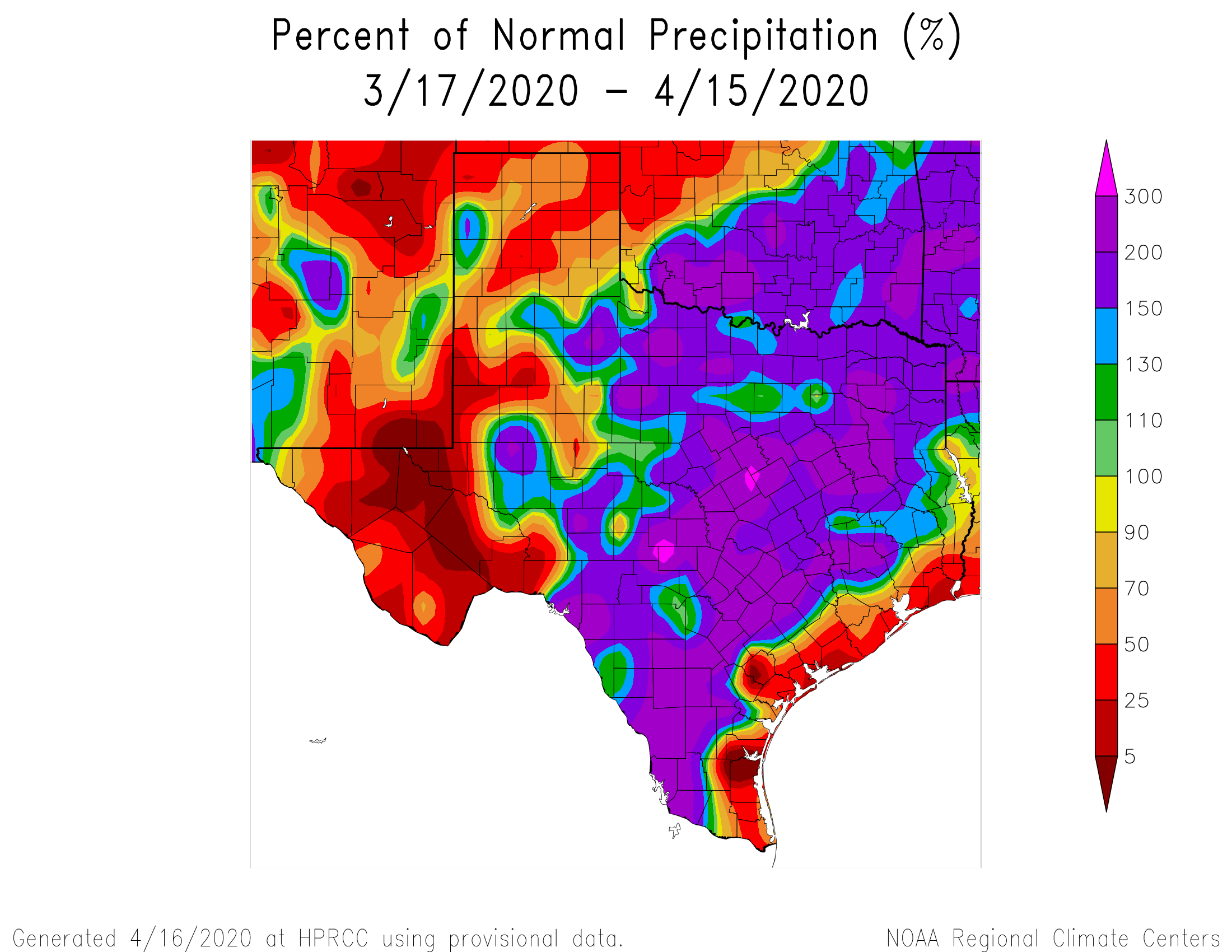
The last several storms tracking across the region have produced seriously mixed results for our area. In fact, if you just look at Highway 59/I-69, you can get two very different narratives on either side of the highway. West or north of 59 has been rainfall rich, with 150 to 200% of normal rain over the last month. That steadily drops to near 25% of normal at the coast on the other side of the highway. There’s nothing special about Highway 59, but it conveniently works as a boundary here.
The last few severe weather risks have also been fairly underwhelming in our area too, with a few exceptions. It’s important to understand that with these types of storm systems in our area, there a lot of things that have to come together to generate storms. This one looks to be no different. And yet again, the best chance for more rain will be to our north and west.
So look for scattered showers, thunderstorms, and downpours on Saturday. Many of you won’t see anything on Saturday, but some folks may see a shot of storms. Severe weather risk is low but not zero. If we do get storms going, look for strong winds or some hail to be the primary risks.
As far as temperatures go, look for us to warm into the 70s on Saturday afternoon.

Sunday
With our area in the “warm sector” on Saturday night and Sunday, all we need is a disturbance to get the show started. That should arrive on Sunday morning. We still are not quite sure what that is going to look like when it arrives. Will it be a larger, well organized complex of thunderstorms moving through? Or will storms be more isolated or scattered in nature? Either way, we are highlighted once again in a slight risk for severe weather by the Storm Prediction Center.
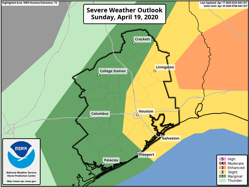
As noted above, not all of us will see severe weather and most of us probably will not but the risk is there should storms get going. Risks for severe weather do increase on Sunday east of the area, especially across Louisiana and Mississippi again unfortunately.
Temperatures on Sunday will probably start in the 70s and head for the mid-80s Sunday afternoon as skies clear. Western portions of the area that see the sun come out sooner on Sunday may make a run for the upper-80s or 90° with lower humidity.
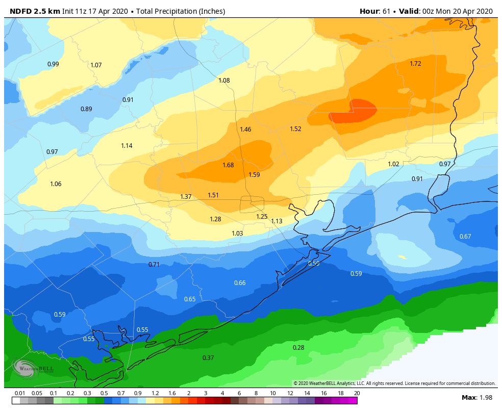
So when this weekend is all said and done, total rainfall will be variable across the region. I expect some places, most likely north and west of Houston to see 1 to 2 inches of rain. Others? Maybe a half-inch, possibly less. We are hopeful for some meaningful rain this weekend in spots that need it, but this could very well end up a situation where the rich get richer once again.
So the bottom line on this weekend is that most of us should see some rain, but the highest totals and highest risk of severe weather occurring would be north of Houston.
Monday & Tuesday
Both days look as if they’ll see partly to mostly sunny skies. High temperatures should be in the low-80s and lows in the 60s (perhaps 50s north). Humidity will be tolerable.
Later next week
Another favorable setup for thunderstorms has been showing up in modeling for several consecutive days now for next Wednesday. We still have more questions than answers at this point, so we’ll just call it a chance of thunderstorms for now and see how things play out over the next few days. We will update you on that Monday.
Matt, I presume last weekend had a capping that prevented those predicted storms to show up, do we have the same set up this weekend? Or was there another reason this didn’t pan out………..
Capping was a big part of last weekend’s issues. I do think we have that again this weekend also, yes. It may be a little easier to break this weekend, but I’m not optimistic it’s going to do so in any significant fashion.