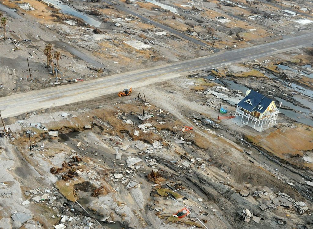
Nine years ago today, Hurricane Ike made landfall along the northern end of Galveston Island. Of a hurricane’s three major threats—damaging winds, storm surge, and inland flooding—Ike’s greatest damage came from its surge along the coast. In the nearly decade since then, we’ve done nothing to mitigate the problem of surge. It would be a great shame if we make the same mistake with regard to inland flooding after Hurricane Harvey.
Now, onto the forecast.
Wednesday through Friday
Southerly winds are back, and with it comes increased humidity and warmer nights. Overnight lows this morning are nearly 10 degrees warmer than just 24 hours ago. We won’t see too much of a difference in high temperatures over the next several days, with the mercury climbing to about 90 degrees or so. But it will feel warmer, given the increased moisture and humidity. This is more typical weather for September.

Saturday through Tuesday
Moisture levels are going to continue rising into the weekend, and this will bring a chance of scattered showers and thunderstorms to the region. Most of Houston probably won’t see rain each day, and areas that do see rain probably will have accumulations of just a tenth of an inch, or two. Highs will be in the low 90s, and overnight temperatures will be in the mid-70s. This is truly what Houston can expect in the absence of a cold front in September, and alas there are none of those in sight. Neither the European or GFS model show much of a change in this pattern for at least the next week or 10 days. The good news is that sometimes mid-September can be sweltering, with highs in the mid- or even upper-90s. But this does not appear to be in the cards this year.
Tropics
Hurricane Jose continues to meander around the tropical Atlantic Ocean, with 75-mph winds. The forecast track for the next five days keeps the storm well away from land (with the possible exception of Bermuda), but then the forecast models are pretty widely split. Ultimately I think it remains away from the US East Coast before eventually fizzling out, but it will have to be watched. Closer to Texas, in the Gulf of Mexico, there are no threats.
I’ll take this mundane forecast…LOVE IT!! Thanks guys for the past few weeks…you all sure hung in there tough and competent!
Need a direct email to discuss business
“In the nearly decade since then, we’ve done nothing to mitigate the problem of surge. It would be a great shame if we make the same mistake with regard to inland flooding after Hurricane Harvey.”
AMEN!
I love these no nonsense right to the point forecasts.
Agreed, I am a big fan and I spread the word
But what to do, limit development within known flood areas, build another reservoir north of Addicks…Im afraid political pressure from real estate and developers will stop any plan to mitigate flooding, and so we are doomed to repeat…Thank you for your work over the last few weeks!
Any thoughts on the “deep tropical moisture” over the Yucatan drifting northwest?
Eric, with regard to the lack of protection against storm surge on the island as well as inland protection against massive flooding, which government agency is responsible for for addressing these issues? Thank you for your insight.
My birthday on the 27th is usually around the time I start looking for cold fronts. I know you’ve had a busy few weeks, but if you could order up one of those bad boys I’d be very much appreciative!
In the nearly decade since then, we’ve done nothing to mitigate the problem of surge. It would be a great shame if we make the same mistake with regard to inland flooding after Hurricane Harvey.
We will make that mistake.
The great Galveston hurricane was in 1900; construction began on the seawall in 1902; and the initial segment was completed in 1904. Imagine a major infrastructure project (like an “Ike Duke”) being initiated and completed on that timescale today! If it hasn’t happened yet, it never is going to happen. And I agree with Peter’s comment above, the developer lobby is too great to do much of anything meaningful to avoid a repeat of the Tax Day or Harvey flooding.
Now it would take two years just to write the damn RFP.
I just want a week with no hurricanes, tropical storms, tropical waves, or “areas of disturbed weather” (please, if you are weather and you need help, see a weather shrink) anywhere in the Atlantic Basin. I don’t think I can handle another one right now.
Thanks for all the work you guys do! I’m pretty happy with this mundane forecast. I’m also interested in learning a bit more about meteorology. What books would you recommend?
We’re actually going to work up a post on this very topic soon! Be on the lookout!
“Ike’s greatest damage came from its surge along the coast. In the nearly decade since then, we’ve done nothing to mitigate the problem of surge. It would be a great shame if we make the same mistake with regard to inland flooding after Hurricane Harvey.”
They should have put stakes in the ground at the high water mark, buy out any properties closer to the water then those stakes and then not allow any permanent structures to be built there. Mother nature needs that buffer…