Good morning. Ida has finally weakened into a tropical storm this morning, and is now slowly, at a rate of about 8 mph, moving away from Southern Louisiana. Much of the region is submerged under storm surge and very heavy rainfall. More than 1 million customers in the state, affecting about half of the state’s population, are without power today. Some will be without power for many weeks. Ida, in short, has left a sobering trail of destruction and misery in its wake. We must help our neighbors, and here are some ways to do that right now.
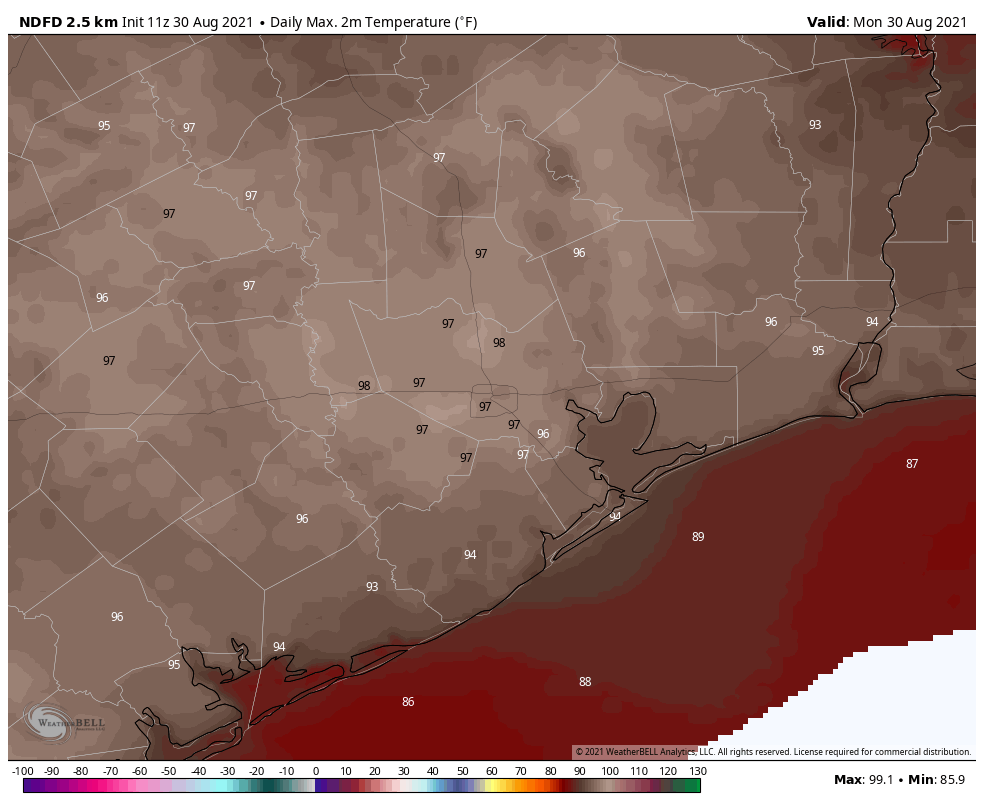
Monday
Today will be hot and sunny, with only a slight chance of showers and thunderstorms. Highs will likely reach the upper 90s. As Ida pulls away from Louisiana, winds will be out of the north and northwest locally, at about 5 to 10 mph, and the overall flow will draw warm air into the region. Rain chances will be down to around 10 percent. Overnight lows will be around 80 degrees.
Tuesday
This will be a similar day to Monday, albeit with slightly higher chances of rain showers, perhaps on the order of 20 percent.
Wednesday and Thursday
Low pressure aloft will bring a modest increase to rain chances by the middle of the week, perhaps about 40 percent for areas south of Interstate 10, and less to the north, and this should also cool temperatures down into the mid-90s. Skies should otherwise be mostly sunny with warm and partly cloudy nights.
Friday, Saturday, and Sunday
While the weekend forecast is not yet locked in, the greatest likelihood is that we see hot and sunny weather, with highs in the mid-90s. As some slightly drier air mixes in, overnight lows may drop into the mid-70s. While not “nice” this definitely would be more pleasant than sultry nights around 80 degrees. Overall rain chances look low this weekend, probably below 20 percent each day.
Tropics
With Ida inland, and an inconsequential tropical depression in the open Atlantic Ocean, what else is there for us to worry ourselves about? The primary area to watch is the southern Caribbean Sea where conditions are somewhat favorable for a tropical depression to develop later this week. The National Hurricane Center gives this area a 20 percent chance of development.
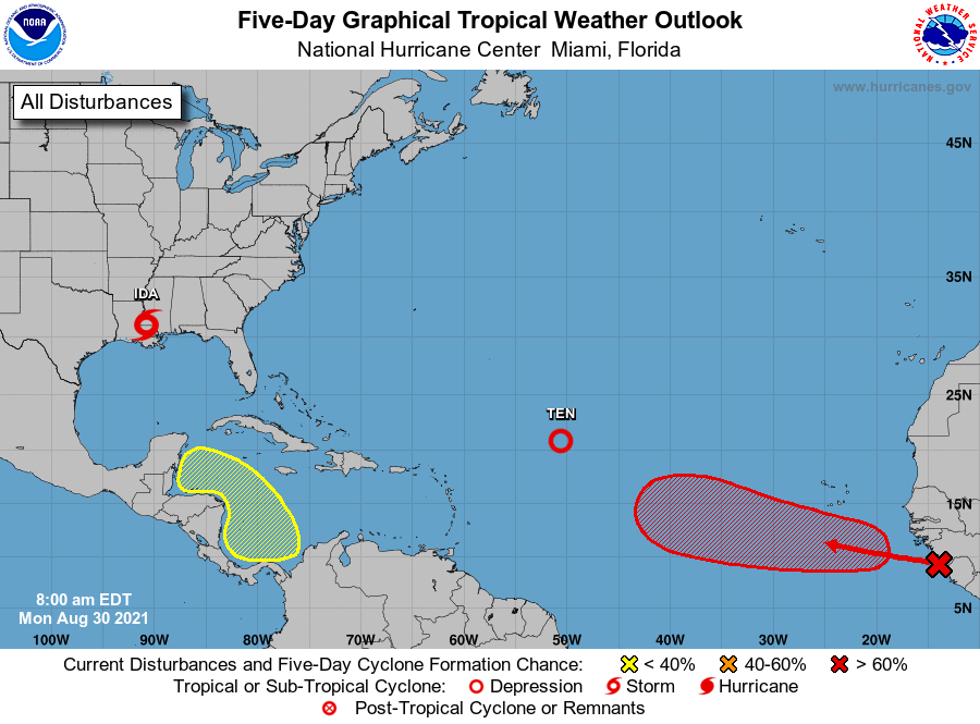
This system is likely to approach Central America or the Yucatan Peninsula later this week, and if it survives interactions with land—which is far from certain—something may eventually move into the Gulf of Mexico. However there is no strong signal in the global models that this will happen, and if it does, there’s little indication it will eventually track toward the upper Texas coast. So while this is something we’re watching, it’s not something we’re particularly concerned about. As for the disturbance moving off of Africa (red X in the map above), it has a high chance of developing but is likely a fish storm that will not bother and landmasses.
The news reports that the New Orleans levee and pumping system worked as intended, so there’s that. The power outage affected some sewage removal pimps that don’t have backip generators.
That’s good that the Levees and pumps held up, but that other problem caused by the power outage sounds pretty crappy.
Not to lessen the other devastations caused by Ida, but I’d much rather live through a hurricane like Ike (no electricity) than one like Harvey or Katrina (flooding, surges, levees and lives destroyed). As Gulf Coast residents, we have to live with the fact that all future weather irregularities will be off-the-charts worse than those of the past.
Good to hear. Lots of people on Twitter are freaking out over a ‘model run’ predicting the blob in the Caribbean becoming a Cat 4 into Houston next week.
People love to speculate, don’t they?
I got off of Twitter due to the misinformation that was being posted and I have discovered my quality of life has improved,
Glad to hear it, don’t need that in your life.
The Canadian (CMC) model has been very persistent on a storm to develop in the area where the 20% grid is located. It has also been very persistent bringing a storm into SE Texas.
Any credence on the CMC? Or is a bit of an outlier needing confirmation from the GFS or Euro model runs before taken seriously?
I value your every word on weather in Houston and throughout the Gulf Coast. Kudos to your team. However, I was extremely disappointed by your link to suggestions of organizations aiding victims of Hurricane Ida, and I wonder the extent to which you vetted these organizations. Two of the three top suggestions have limited expertise and infrastructure for disaster relief, their focus being environmental issues and social equality. Both are worthy concerns, to be sure. However, there are organizations for whom disaster relief is at the center of their mission. I would recommend that your readers donate to the American Red Cross (https://www.redcross.org/donate/hurricane-ida-donations.html/). Days prior to Ida’s landfall, the Red Cross was prepositioning supplies, establishing and staffing shelters, and delivering blood products to local hospitals from Beaumont, Texas to Mississippi. Red Cross staff and trained volunteers are now working–with skill and compassion–in those shelters and hospitals to help those affected by this disaster. Since 1881, the Red Cross has been the gold standard in times of need. The organization merits our admiration and support.
Eric, thanks for keeping abreast of science and refusing to cave into the hysteria that many local meteorologists adhere to. I know when you declare danger, it’s time to go. One of my biggest regrets is that you never got the chance to speak to my journalism students. Another one was not getting to see Ana to graduation. Again-thank you for always being the voice of reason.
The local meteorologist did a fine job reporting this storm. I didn’t see any hysteria. The only “acting” I saw were reporters in the field. Doing the mime thing with the wind. Ridiculous.
Thanks, Eric. NWS posted today that it’s been 365 days since Houston hit 100 degrees (officially). So, there’s that. Ha
Thank you for everything you and Matt do.
Eric – Is a fish storm like a Sharknado?