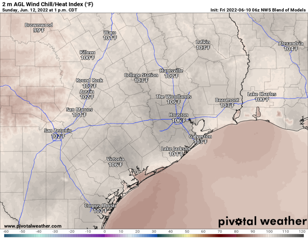
Summer will continue to tighten its grip on Houston this weekend with at least 3 straight days of near-100 degree temperatures ahead. On average, our first 100 degree day isn’t until mid-July. Many years don’t see one at all. In fact, our last 100 degree day was August 29, 2020 on the backside of Hurricane Laura. We’ll see if we break through this weekend.
Drought continues to be a notable topic. While it’s been hot quite early, this setup remains very unlike 2011, so let’s not use that as a comparison. Some other drought years in the 80s and 90s are probably more applicable comparisons. Drought coverage actually improved statewide over the last week, thanks to some showers and storms in West Texas. East Texas saw drought begin to expand again. In the Houston area, we were up about 10 percent week over week.
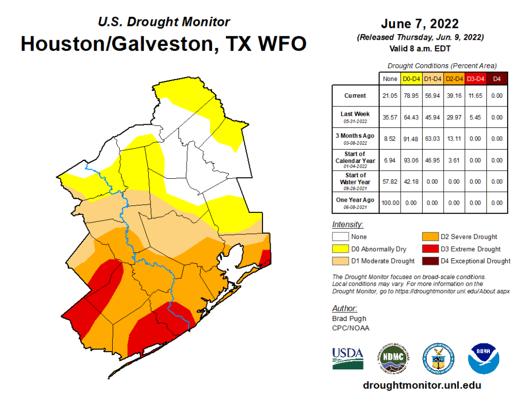
Harris County is now almost fully covered by drought, with some severe drought now taking hold across the southeast third and nearly all of Fort Bend, Brazoria, and Galveston Counties. Extreme drought expanded this week to cover portions of Brazoria, Matagorda, Wharton, Chambers, and Jackson Counties. With no meaningful rain likely over the next week and 100 degree weather, it’s safe to assume this will expand further next week.
Today through Sunday
As noted above, expect sunshine and heat on repeat. It will be near or above 100 degrees inland each day, in the 90s at the coast, and all locations will see 70s to low-80s each morning. Please do take it easy this weekend, as our bodies are not acclimated to this sort of high summer heat yet. Heat advisories are a virtual guarantee this weekend.
Early next week
The large area of high pressure over Texas helping to fuel the heat this weekend will begin to slip eastward on Monday and Tuesday. This will at least open the Gulf up a little bit for some daytime sea breeze thunderstorms. While rain chances still look rather pathetic and no better than 10 to 20 percent each day, it’s still a bit better than it has been. Because the core of the heat does pull away, this should allow us to “cool” back into the mid or upper-90s for highs each day with nighttime lows still in the 70s to near 80 degrees.
Later next week
Another area of high pressure is going to surge into the southern Plains for the end of next week.
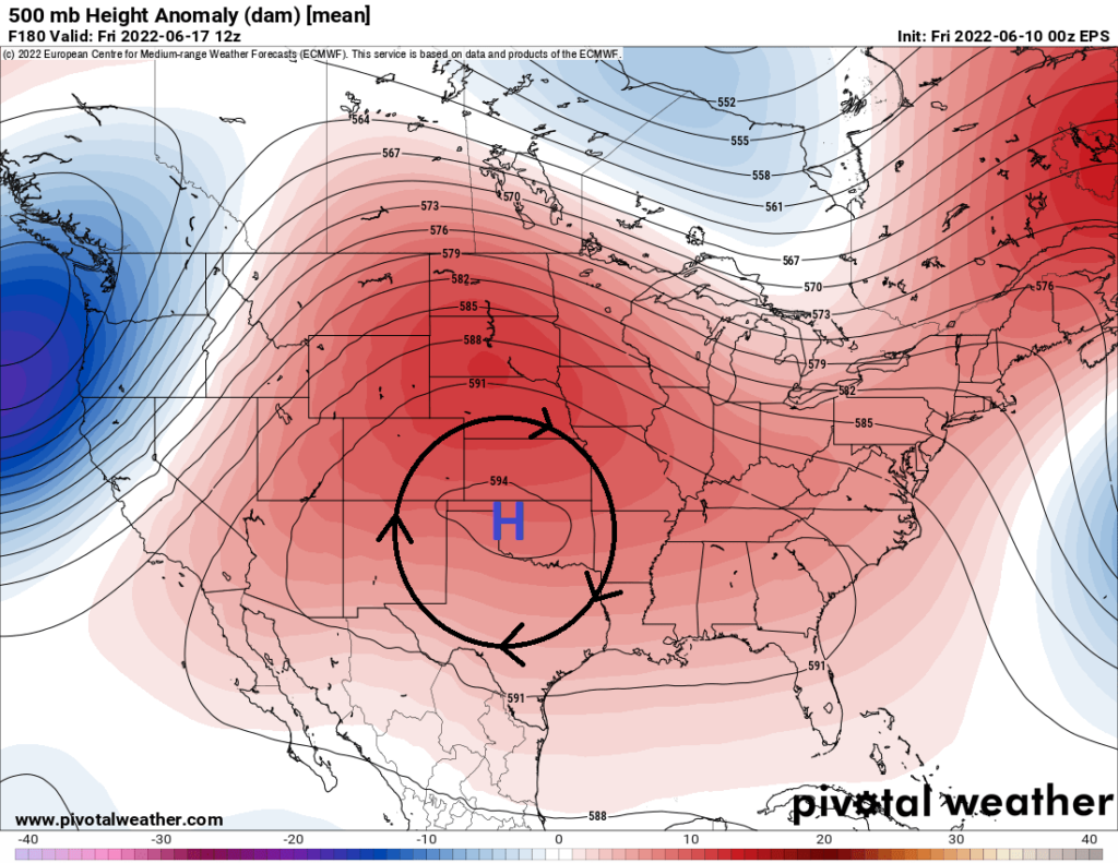
This one looks to anchor a little farther north than the one we see this weekend. While this will likely keep the door cracked open for some sea breeze storms each day, again, chances look rather low and temperatures may creep up another degree or two.
Bottom line: Excessively hot and humid for June over the next week, with heat peaking today through Sunday. A little “less hot” next week with non-zero rain chances (but still low). Maybe hotter toward next weekend again with continued generally low rain chances. The next 2 weeks of rainfall anomalies per the European ensemble model?
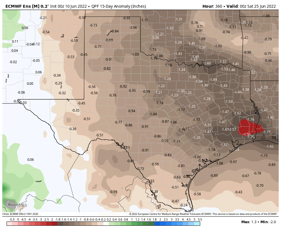
Ugly.
Tropics
Some models do continue to try and put a disturbance in the Bay of Campeche late next week, but no reliable model develops it into anything organized at this point. So nothing for us to worry about out there or on the horizon.
This is the kind of heat that you wish it would at least be windy – to move the hot, humid, and heavy air around.
Since we’re not getting that, maybe we can hit the fast-forward button on the calendar to jump up to August 31 so we can get this “Bataan Death March” of summer over.
It has been windy, just get out on a bicycle or motorcycle, and you’ll find it. It’s not that hot out. This must be dry heat.
Here in Cypress at 2:00 95° with 51% humidity. Not that bad.