The onshore flow gets going today, and eventually that moisture will bring the threat of thunderstorms by this weekend.
Today
After another day of low humidity on Monday, conditions will change today as the onshore flow really gets cranked up. We’re going to see increasing southerly winds, which may gust above 20mph, and will raise moisture levels across the area. This may bring some clouds this afternoon, but rain chances will remain near zero as high temperatures rise into the mid-80s. Lows tonight will be warm for late spring, only falling into the low 70s.
Wednesday
Wednesday will be another very warm day, with highs in the upper 80s, but will be punctuated with some uncertainty during the late afternoon and evening hours as a cool front approaches the area. While a cap may limit rain activity, and conditions are not ideal, this front has the potential to produce a broken line of thunderstorms as it moves through Houston later in the day and during the late evening hours. Even so, I’m not anticipating any kind of significant accumulations for areas that do get rain. Temperatures will fall off fairly quickly late Wednesday night after the front’s passage.
Thursday and Friday
The cooler conditions will be short-lived, however, and effectively end later on Thursday. The first half of the day will nonetheless be quite pleasant for the Houston region, with lows dropping to the upper 50s for inland areas, and lower 60s along the coast.
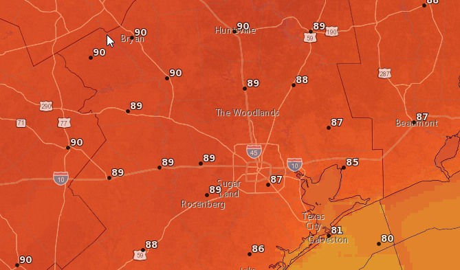
Look for sunny conditions on both Thursday and Friday, with highs in the mid 80s Thursday, and upper 80s on Friday. I would not be shocked to see the region’s first 90-degree day of the season on Friday, either, but right now I’d bet against it.
(Space City Weather is sponsored this month by The Mole, a Jonathon Price novel.)
Saturday, Sunday, and beyond
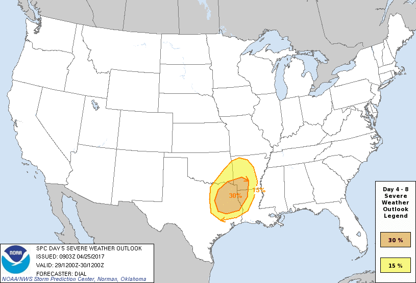
For those planning outdoor activities this weekend, or crazy enough to ride their bikes from Houston to Austin as part of the BP MS 150, there are some concerns to talk about. Saturday will be quite warm, and start out with a brisk southerly breeze (which will help riders). However as a large upper-level low pressure system spins out of the Rocky Mountains and moves eastward across the United States, a cold front is going to move through Texas. Right now it appears the best chances for any severe thunderstorms are over east Texas, north of Houston.
However, I’m still pretty confident that the region from Austin to Houston is going to see some rain showers during the Saturday afternoon through Sunday period, with some embedded thunderstorms. Accumulations might be 0.5 to 1 inch for most areas, with higher local amounts. (My hope is that most of the rain comes during the overnight hours, but that’s just a hope at this point). An accompanying cold front will move through late Saturday and on Sunday, and this will provide a brisk northwesterly headwind for riders on Sunday.
Conditions will be cooler for Houstonin the wake of the front, with a few high temperatures in the 70s, and overnight lows on Monday and Tuesday morning in the mid-50s for much of the region, perhaps a bit lower for inland areas such as Montgomery County. Too bad the weekend will be over.
Posted at 6:45am CT on Tuesday by Eric
meh, head winds. Just drop a gear and keep on pedaling. Pain is just weakness leaving the body.
No, not like that.