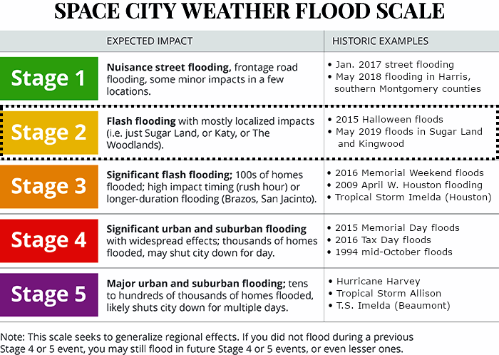
Good Saturday morning! We’ll be with you here all weekend on Space City Weather to track the progress of Tropical Storm Beta, and its effects on Houston, Texas, and Louisiana. Broadly speaking our forecast has not changed a whole lot. For now, on our Flood Scale, we are still calling for a Stage 2 flood for areas south of Interstate 10, and a Stage 1 flood for areas north of Interstate 10.
With this system we are most concerned about the potential for heavy rainfall next week, and then rising seas along the coast due to a prolonged period of winds from the east-northeast. Probably the most important thing we can tell you this morning is that there is still a lot of uncertainty in the track forecast for Beta, and where the storm’s heaviest rains will fall. We suspect this storm will have some surprises in store.
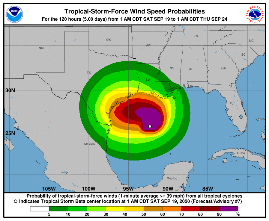
Track
As anticipated, Tropical Storm Beta has moved north overnight, and now lies nearly 300 miles due east of the mouth of the Rio Grande River. Pretty soon we expect the storm will run into a ridge of high pressure and take a westward turn, gradually moving toward Texas. We are reasonably confident that the storm will then approach the Texas coast somewhere between Corpus Christi and Matagorda Bay on Monday, potentially as a strong tropical storm or a Category 1 hurricane. Through Monday this track should keep most of the heaviest rainfall just along, or off the coast. So far, so good.
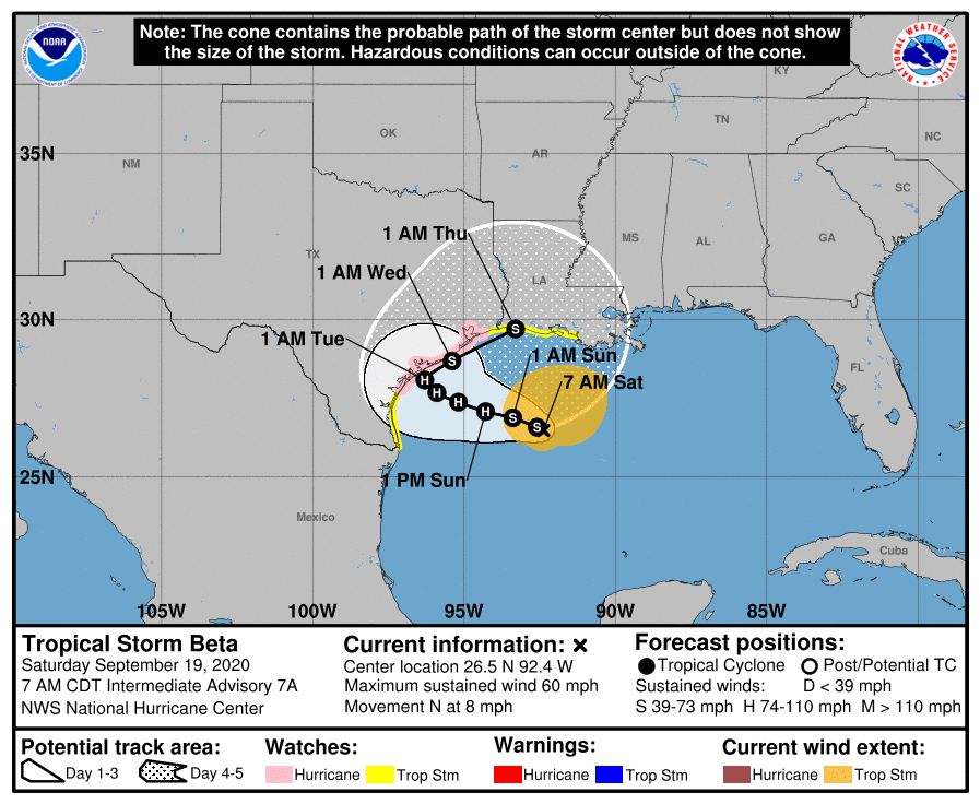
The problem is that, after this point, we’re not really sure what will happen. The National Hurricane Center’s official track brings the storm to the northeast on Tuesday, along the Texas coast, as weakening high pressure allows for an exit. However, it also seems possible the storm could move 50, or even 100 miles inland before making this turn, or remain 100 miles offshore. I know what you’re thinking, slow-moving storm, landfall near Corpus, moving inland—Eric, that sure sounds a lot like Hurricane Harvey. Well, I’ll agree, but there are some key differences here. Most significantly, Beta lacks Harvey’s organization, and will be fighting dry air as it moves toward Texas. This may help to limit inland rainfall. Moreover, the storm really should move away by Tuesday or Wednesday, so we are probably not looking at a four- or five-day heavy rainfall event.
Rainfall
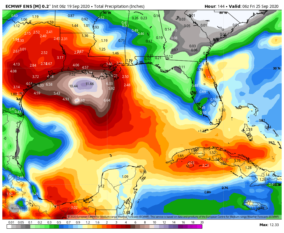
So how much is it going to rain next week? The global models have trended slightly downward in terms of rainfall accumulation during recent runs, and I think a good general expectation is 2 to 8 inches across much of the Houston metro area, with coastal areas potentially seeing 6 to 12 inches between later Sunday and Thursday. That much rain over four days is manageable, so our concerns are very high rainfall rates—which tropical storms produce—and higher than anticipated totals. We can’t rule out some 20-inch bullseyes, but so far there’s not much support for this in our best models. I think the bottom line is that we need to prepare for heavy rainfall through Wednesday or so of next week, and the possibility of flash flooding. But it may not come to that.
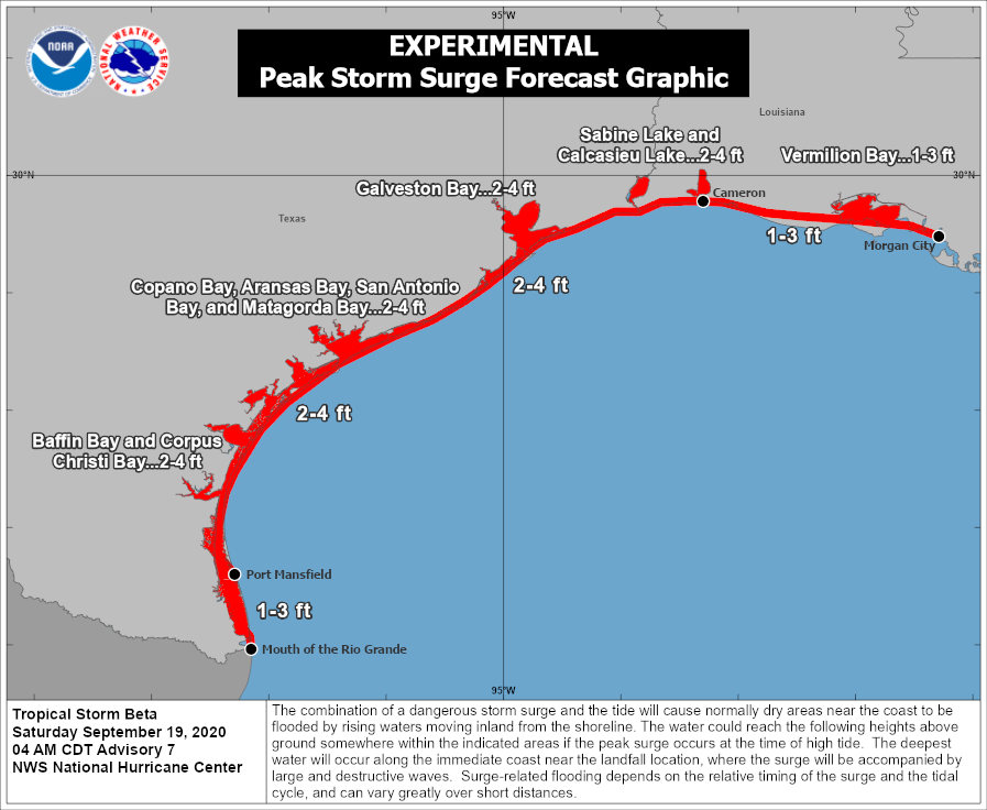
Storm surge
The other issue we’re going to face is storm surge as Beta produces strong easterly winds over the area. For now, Hurricane Laura’s water levels, plus one or two feet, is probably a good guide for what to expect from Beta along Galveston Island, Bolivar Peninsula, and Galveston Bay. However, this part of the forecast remains very much subject to change, given Beta’s track and intensity.
Winds
Winds will begin to increase across the area on Sunday and Monday, and there is a 30 to 40 percent chance that the Houston metro area will see tropical-storm force winds next week, with higher chances along the coast. This forecast, too, is very dependent on track and intensity so winds are a work in progress. But right now the expectation is that wind should not be too disruptive in terms of power outages across Houston.
Our next update will be posted no later than 2pm CT today.

I don’t think that’s what “due east” means… 🤔
Look at the last picture. The white spot is the eye, and thus the center of the storm. And that is due east of the mouth of the Rio Grande.
You’re right, Martha. Thanks!
Never mind. I thought you were describing the new predicted landfall location. Disregard. 😊
Stage 1.5 is when flooding affects only Katy.
When will a more understanding of track be presented with this storm?
That’s what I’d like to know too.I am full of horrible anxiety today..My fur baby is fresh post op, surgery was done yesterday, he has a draining painful wound..It hurts him to move around..The prediction timelines for this years hurricane season, along with the tracks seems to have been somewhat poor, until these storms are right on top of us..I don’t really have anywhere to evacuate to except to hotel, I have not reserved a room further inland north yet..With info presented this morning, I wouldn’t be inclined to evacuate my home in La Porte Texas..With that said, I’m dreadfully terrified of the thought of having to be rescued by boat from a home inundated by rising waters with my newly recovering dog in tow..
I believe it was in one of his posts yesterday that this storm has to be taken a day or two at a time with all the uncertainty. You new around here 🙂
Yeah, just not thinking very clearly.Slept on a pallet last night next to my dog, not much sleep..
Do we know when the leak storm surge will be?
Eric, if – and I realize that the track is uncertain now – the storm moves as anticipated, what type of wind speeds might we see up near Bush IAH, or the Kingwood area?
Thanks Matt and Eric! Given the uncertainties right now, how confident are you that Beta will not be a hurricane when it reaches the Houston area? Thanks!
As good as hurricane forecasting has gotten we all need to remain mindful that storms don’t read the forecasts. This far out it could be a nothing—-OR, a significant event for the Houston area. I’m hoping for the former, or something minimally above that. We’ll see. Thanks guys. we appreciate what you do.
With all the concerning storms you guys must be setting a record for year total views. Reliant’s certainly getting their moneys worth out of you guys!
Eric and Matt, thanks for your dedication to the GH community. We appreciate your data driven analysis and no-hype forecast.
Can I make a request? Is it possible for you all to show a pin on the center of Houston (maybe downtown Houston?) in all your images? It would make it much easier to visualize where the different levels of hazards (wind, flooding, etc.) are. Thanks for all your efforts! We appreciate you guys.
Hi Hilary, I usually just look for Galveston Bay and it helps with orientation on these maps. Its pretty unmistakable once you get use to looking for it.
It’s not always clear where that is on the images. This post is ok but others from the past it’s hard to tell.
Thank you for the honest update. Try to enjoy the weekend gentlemen!
Love the Greek metaphor as we look to the Alpha and Omega to get us through another storm season.
Think it’s cookie as in Do you have any Beta on your hook?
Thank you for reiterating “This isn’t Harvey”!! Thru all the uncertainty, you guys save my sanity. Thank you for everything you do!!
Love, love, love your weather reports. Easy to understand without the flowery language. Straight and to the point! Thank you!
Looks ominously like Harvey to me.
Your flood stage index is excellent. I hope you have copyrighted it.
Thanks as usual for low hype and high information posting.
You guys are much better than what you see on TV
Thank You, as usual, for Your great posts!!!
And, after all the magic day-September 25 is getting closer…Eric was saying that after that day, the likelihood of storms for Texas is going down…
OTOH, Matt has said that in this highly active year he doesn’t think that September 24/25 is going to be magic.
JUst because I am not fully understanding how storm surge works, could you give a quick explanation on how the surge in Galveston Bay would affect Clear Lake and the many communities that surround the lake?
Clear lake/ Clear Creek is effected by both heavy rainfall and tidal surges. They have the flood gates installed at Seabrook, but it’s always been unclear to me if they actually accomplish anything.
I live a block off of Braes Bayou east of the Med Ctr and had 3 ft. of water in my house in both Allison and Harvey but none any other time. I know you aren’t prescient but what are the odds off even one inch this time?
I need to move my furniture if 20% or more. When will it be possible to answer this question with clarity?