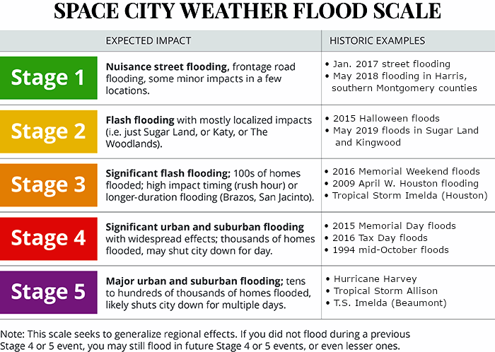
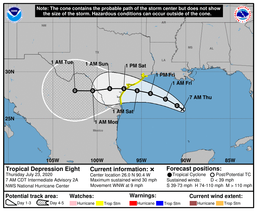
Good morning. This post will focus on Tropical Depression 8, because after today it will strongly influence our region’s weather through the weekend. Overall, our forecast for this tropical system has not changed a whole lot from yesterday: We are predicting a Stage 2 flood event for coastal counties (plus southeastern Harris County), and a Stage 1 event for inland areas of the Houston region. In short, for most, this probably will be a wet weekend, but not a wholly disruptive one. But as always with tropical weather we’re going to watch this one closely.

Thursday
After several wet days, with parts of the area such as Clear Lake and Pasadena picking up 5 to 7 inches of rainfall, today should bring partly sunny skies and some time to dry out swampy yards. Rain chances are probably below 20 percent for most, with warm afternoon sunshine helping to dry soils out and pushing highs into the mid-90s. This will be hottest day until at least early next week. Winds will be light, out of the east to northeast.
Friday
The forecast for Friday morning is similar, with low chances of rain through at least the morning hours and perhaps into the afternoon as well. However, starting around sunrise or shortly thereafter, we’re likely to see winds pick up out of the east to northeast at about 15 mph. Rain chances pick up during the evening and overnight hours as the outer bands of the tropical system reach our area. After that, our weather is largely dependent upon the tropical system’s track and the vagaries of its structure.
Tropical Depression 8
This system remains poorly organized this morning, with the center displaced from most of the convection. However, the depression still has about two days to get organized, and if it can get a good spin going there won’t be much to stop it with low shear, warm waters, and fairly moist air at the mid-levels of the atmosphere. The official forecast calls for an intensity of 45 mph sustained winds at landfall, making for a weak Tropical Storm Hanna—but I’d characterize this as fairly low confidence. We could see anything from a depression to a strong tropical storm or even a moderate hurricane.
In terms of track, we have more confidence, with the system likely moving into Texas between Brownsville to the south, and Matagorda Bay to the north. Unless the system undergoes rapid intensification, the primary threat to Texas will be rainfall, and that can be expected anywhere along the coast.

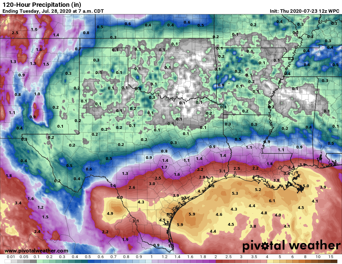
Our general expectation remains 2 to 4 inches for inland areas of Houston, with 4 to 6 inches possible along the coast from Matagorda through Port Arthur. This is entirely manageable, especially if spread out from Friday night through Sunday. However, the problem with tropical rainfall is that it can come in bunches, with high rainfall rates that quickly lead to street flooding, or worse. The potential for this, and the possibility of rainfall bullseyes of 10 inches or more, prompted us to call for a Stage 2 event for the coast.

The big picture is this: The tropical system coming to Texas is a potential rainmaker, but it should continue to move west after landfall, helping to clear it from the area by the end of the weekend. Generally, then, we are not too concerned about this weekend’s potential for widespread flooding. This is far from the most threatening tropical storm we’ve seen, or may yet see this hurricane season. So we’re watching the system, and so should you. But don’t be too worried at this point. We’ll have more later today.
Phew… even and realistic forecasts are why Space City Weather is my go to every day of the week!
Do you guys think there’s any worry for large tide surge along the mid coast region?
Winds aren’t strong enough for much surge.
Should we leave Galveston if we are here for the weekend? Car parked on street…
Hi, Galvestonian here. No need to leave but definitely move your car. Our drainage system takes a while to get rid of the water so if it comes down heavy, it will flood.
Really appreciate that you increase post frequency during these types of events. I’ll be reading each one. Thank you!
Another voice in the chorus of appreciation for the factual, hype-free forecast!
Any insight as to impact for San Antonio and hill country region near there?
Any idea of what time Friday evening will we start to see these bands?? I don’t want to cancel my plans but will if I need to.
Hey folks, blame the rain on me. I just installed a sprinkler system in the yard, so the plentiful rains were bound to happen…
Quick Q — on Friday, sunrise=sunset?
As I read it, I think he says sunrise Friday is when the winds pick up; sunset Friday is when the heavier rains set in.
I hope The woodlands gets the 2.2 inches that NOAA forecast. We’ve been skunked so badly the last 3 days, literally nothing more than sprinkles. Forgive me for being skeptical of this rain forecast because the tract has been shifting further south. I’m sure it will rain south of I-10, but I sure as hell am leaving my sprinklers or lest I risk letting the yard die.
It’s depressing how little it rains here….or maybe i just took the drought from California to here when i moved here.
Haha, yes I just put down some sod last week and was hoping we would get a decent sprinkling. No such luck yet.
Please move the 1994 October flood from stage 4 to stage 5. It was at least equal to Allison, but not quite as bad as Harvey.
I think it was highly dependent on where you were for 1994. I was a kid in the Woodlands back then but it was devastating for us and people in Conroe. People further south, not so much. Allison on the other hand crushed downtown and South. While we got plenty of rain on the North Side it wasn’t as bad.
Galveston west end has measured 7.29 inches of rain since Friday. The ground is very wet and wetlands are filling up. Thanks again for your amazing factual weather reporting!
At next update pls let us know your thoughts on Gonzalo…Is there a chance we will have to deal with his mischief in another week?
Another reason why I trust SCW. Watched local news today and they said “The American model is no where near aggressive enough in terms of rain predictions” (proceeds to chuckle), “so here’s our proprietary model showing up to 6″ of rain across Houston.”
Two words: Outer Bands. Get some of those “bad boys” training over your area and that’s all that matters.
I wish forecasts were more concerned with when the rain bands hit. They generally precede the center of the storm which, with a rain event, is not as significant.
I love this line: “ We could see anything from a depression to a strong tropical storm or even a moderate hurricane.”
That ought to cover the bases! 😄
We are leaving Saturday to drive to Myrtle Beach, SC. We were planning to drive along the coast, but do you think we should alter our route and kick north instead? I’m thinking LA is going to be a mess!
Best weather forecast in the area. Bravo!
Time to evacuate to Katy!
Richard…I cracked a big smile over this. I think this dates back to Hurricane Ike. I am sure Katy people will disagree with me but some jokes never get old.
This always cracks me up 😆😆
Do you think it would be unsafe to drive from McAllen to Houston Saturday late morning?
I still think the whole, “threat level midnight” color coded scale thing is a little hokey, but you guys are so much better than the TV.
Eric,
This storm and the previous seemed to track straight across the Gulf. Does the track of these storms have any indication of the storm tracks for this season?
I saw on the news that we might want to anchor down trampolines and bring in outside patio furniture. I live in Sugar Land. Will the winds we get outside of the coastal counties really require that? I don’t want to put in a lot of work for nothing. It seems like a rain event wouldn’t really require it but I am not sure if that is TV weather hype.
We are driving home from Colorado on Saturday, and we will be en route from Wichita Falls to Houston via Dallas for a portion of the day. Do we need to worry about flooding during our trek home? Or is this out of the way.