By now, we’ve all been inundated (pardon the pun) with model graphics such as the one Eric shared earlier this morning:
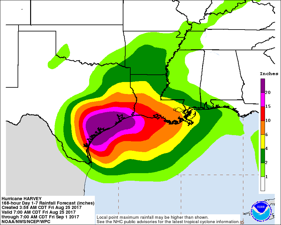
As he mentioned, it is indeed a realistic portrayal of the rain our area could get over the next week. Twenty-plus inches of precipitation in such a short period of time is daunting, especially when you consider Houston averages around 50 inches a year.
We’ve had a number of questions about how the area’s bayous will manage the rain. Surely, they could handle four inches day, for five days, right? Unfortunately, for tropical systems like Hurricane Harvey, it isn’t the amount of rainfall that becomes a problem, as much as the rainfall rate. What is rainfall rate, and how will it and other factors influence how bad our flooding will be this week?
What is rainfall rate?
Rainfall rate describes how much rain falls over a period of time, and is measured in inches of rain per hour. A rainfall rate of 0.5″ per hour is considered heavy, while anything above 2.0″ per hour is intense. For context, Harris County experienced a maximum rate of 4.7″ per hour during the 2016 Tax Day Floods in a few isolated locations. It’s the difference between your sink faucet dripping for a week (a low rate), and your faucet breaking off for a half hour (a high rate). The same amount of water may come out of your pipes, but one will flood your kitchen much faster than the other.
Ditches and storm drains in Houston and Harris County can generally handle a rate of 1″ to 2″ per hour, for a few hours. Anything higher than that, over a longer period of time, leads to excessive runoff that can flood roads and fill the bayous faster than they can handle it.

Rainfall rates and tropical storms
Intense rainfall rates naturally come with tropical systems, due to the tons and tons of moisture they contain. In 2008, Hurricane Ike reached a maximum 1-hour rate of 4.1″, and a 12-hour maximum rate of 12.7″. At times in June 2001, Tropical Storm Allison’s rainfall rates varied between 4″ up to 6″ per hour.
However, tropical storms do not dump rain evenly over an area. Areas that get hit by more of a hurricane’s rain bands, or are in the path of the eyewall, will receive greater rainfall rates for longer periods of time. Moreover, rainfall rates are more intense on the right side of hurricanes–and Houston is forecast to remain on the right side of Harvey for several days. You can clearly see the rainbands and areas of heavier precipitation on today’s radar loop for Harvey, as it approaches the coast:

During a hurricane, even after landfall, the thunderstorms within it constantly develop, pour down rain, dissipate, and redevelop. The storm is constantly pulling moisture, and fuel, for rain from the warm Gulf waters. Additionally, unlike a small thunderstorm with an intense rainfall rate (something that causes localized flooding all the time here), tropical storms are hundreds of miles wide, pulsating with different waves of intensity that last for days and days. All of these factors can create a perfect storm (again, sorry for the pun), and explains why someone in downtown Houston can get 5 to 10 more inches of rain from a tropical system than their cousin over in Katy. Distribution of rainfall in storms such as these can vary wildly over a small area.
What does it mean?
Let’s look at that forecast for 20+” of rain again, but now in the context of rainfall rates. If 20+” of rain falls gradually, over the course of the next week, flooding will definitely occur—but it would be manageable.
However, we are in the path of a large tropical system, bursting with moisture and primed to dump rain at very high rainfall rates. Therefore, rainfall that overwhelms drainage systems and bayous seem likely. If you are interested in monitoring Harvey’s rainfall and impact on Harris County’s water channels, follow live data from the Harris County Flood Control District here.
Tropical systems can be erratic and unpredictable in their rainfall intensity. This is why, when you see feet of rain forecast for a storm such as this, it’s best to plan for heavy rains and extended periods of flooding. If your area is prone to flooding after storms with high rainfall rates, it’s likely to happen again this weekend.
We will be back with a comprehensive forecast for Harvey and Texas by around 2:30 or 3pm CT.
Posted at 1:15pm CT on Friday by Braniff
Thanks for the update.
Any comment/update on impact on Addicks and Barker dams on West side of Houston?
Hi guys, love your site and have been recommending it to everyone. Rather than witness my third flood in 3 years at my home I’m staying with family down in Rosenberg. I was looking for a similar website to FWS for Ft Bend County. I haven’t been able to find one. Any ideas? Thanks!
Try this for rainfall totals and river levels: http://www.fortbendcountytx.gov/index.aspx?page=1189
Interesting how the lightning is way out from the eye. https://www.lightningmaps.org/?lang=en#y=30.1893;x=-97.1331;z=6;t=4;m=normal;r=0;s=200;o=0;b=;n=0;d=9;dl=2;dc=0;ra=1;dn=1;
How realistic is it to stay home if we live 2 streets from Braes Bayou and there is a history of flooding in the area?
If the area has flooded in the past, I would exercise caution. Watch the conditions over the next few days and have a good flood plan in case it gets bad!
I sent a question earlier
I lived here during Allison. It flooded pretty badly near braes.
Do you have a second story you can climb up to? If not, I’d suggest you depart. I’m near the White Oak, one story house, flooded in Alison, and am heading to the house of a friend with a second story. If you stay, you’re looking at the possibility of being there with no opportunity to leave for several days, possibly with flood water inside the house. You ‘ll want to consider whether to move your vehicles to higher ground (parking garage perhaps) as well in order to keep them out of ‘s way.
We have flooded twice and live one block off of brays bayou in Meyerland. We lifted our furniture up today and will be leaving as soon as it starts getting bad.
Here is a very beautiful wind graphic:
https://earth.nullschool.net/#current/wind/surface/level/orthographic=265.24,26.69,3000/loc=-91.669,27.199
Aare the 20 + inches of predicted rain over a period of time (how many days?)
The rain accumulation graphic is a forecast through September 1st. So 20+ inches over the next week.
Are the 20 + inches of rain over the next week a daily accumulation ? I hope not in one day.
Great information. I look forward to continuing reading it.
Thank you for the perspective about rain rate. Can you tell us how long it has been since a hurricane hit the Texas coast and what the raib rate was like in that event?
I mention in the piece that Ike (the last hurricane to hit Texas, in ’08) had a max 1-hour rate of 4.1 inches of rain. But keep in mind that no two hurricanes are created equal! The rates can vary from storm to storm, and from location to location.
‘In 2008, Hurricane Ike reached a maximum 1-hour rate of 4.1″, and a 12-hour maximum rate of 12.7″.’
This was mentioned in the post. Ike was the last hurricane to hit Texas.
Excellent article, very informative…thank you…I gather the City of Houston would have a higher rainfall rate, than say Cypress, as it is closer to the coastline…
Thank you for all you do!
Eric,
One of the tips I am reading on the forums is to fill bathtubs with water, so that the water can be used for flushing toilets etc.
We live in Sugar Land, and apart from a whole house water softener system, we also have RO based water treatment for our drinking water in the home.
Two questions:
1) Do you foresee an impact to city water supply in the case of severe flooding (or a direct hurricane hit)? Has this ever happened in the past?
2) Should there be no impact to city water supply, are the water purification processes mentioned above be sufficient to ensure good drinking water supply? Should I be concerned that I didn’t stock up on bottled water?
Your site serves both to inform and to educate
Thanks for doing a great job at both.
We’re new to Clear Lake. How can I find where flooding has occurred historically?
Matt, if it comes inland then goes back out to only come inland again, will we have time to evacuate? Lake Jackson is not evacuating at this time. Thanks for all you and Eric do for us.
Eric – what’s your gut feeling on the chances of whether we will already have impassable roads inside 610 loop by tomorrow morning?
Any thoughts how bad it will get in the Tomball/Magnolia area? We are literally only just getting back on our feet again after the Tax Day and Memorial Day floods last year and a repeat of same now would be catastrophic for us.
While all of this is true, the second part of it becomes the really worrisome part. IF the European model is correct and Harvey hits SW of us, stalls, and then gets pushed back into the Gulf and meanders up the coast as a TS, it would bring a storm surge with it into Galveston Bay. The entire region, whether Buffalo Bayou or the Brazos River, ultimate outfall is the Bay. If the storm surges raises the water level 2,3,4, 5′ that will cause the Bay to back up into the bayous and prevent them from draining. This is occurring while we would still be receiving rain from the TS. With the ground already saturated and bayous already at capacity, the flooding would be widespread.
Harris County Flood Education Mapping Tool located at harriscountyfemt.org is a good site for checking a location for flooding potential. It shows 100 and 500 year flood plains and areas outside of either. If you have lived Harris County very long you can recognize that the flood plain names are misleading and that it floods both with a frequency not captured in the percentages given.
I am interested in the question regarding the water supply as well. I live in an apartment and have a shower, but no bathtub.
Great info, thanks!