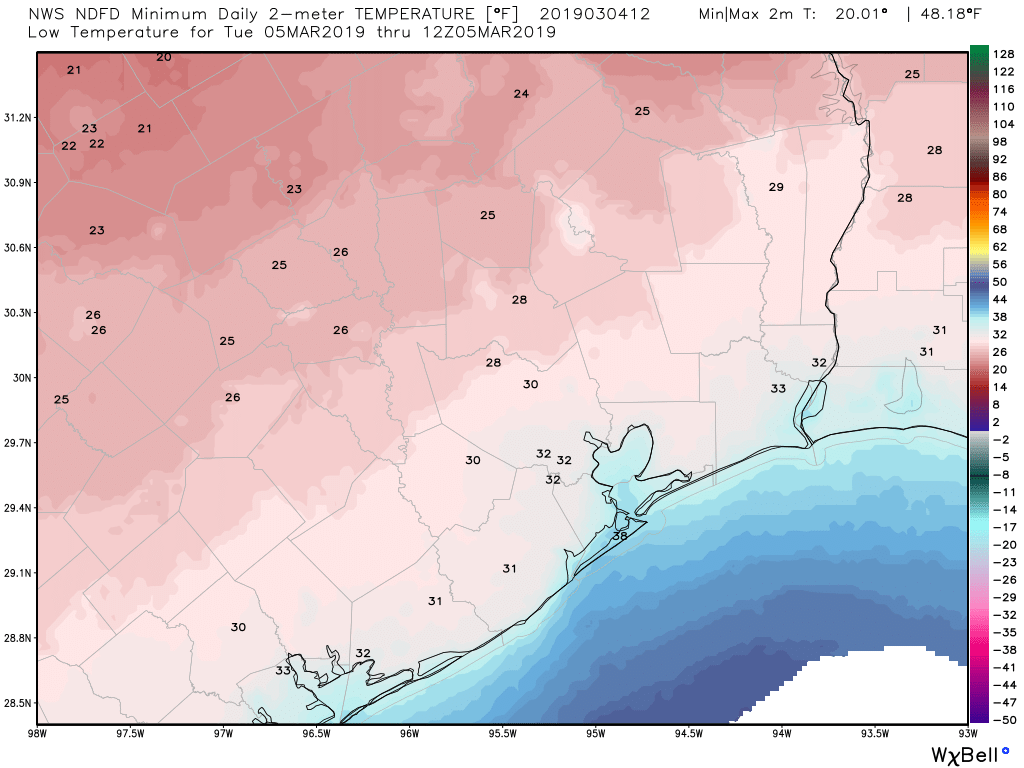
Temperatures are very cold this morning across the Houston region, ranging from near freezing for inland areas to around 40 degrees right along the coast. Gusty, northerly winds have pushed wind chill temperatures into the upper 20s for most of the area, so please bundle up before heading out today. Much of the region will see a freeze on Monday night as modified Arctic air spills into the region.
Monday
It will be cold all day. Clouds should hang around for most of today, before some clearing this evening, keeping high temperatures to around 40 degrees. High pressure over the central United States will continue to drive strong northerly winds for most of today, with gusts of around 20 mph, so wind chills will likely remain in the 30s all day. Some light, misty rain will be possible, especially near the coast, but accumulations should be near zero. In short, it will be extremely cold for early March. As skies clear tonight we will see ideal conditions for cooling, and a freeze may well extend into the central Houston area.
Rodeo weather

Well, it’s going to be chilly. Temperatures at 6pm will be around 40 degrees, with rain chances near zero, and fading northerly winds. Not much will change after the rodeo is over, although skies may well be clear after the show. So you might be able to look up and see a few stars as you’re shivering your way back home. Please dress warmly.
Tuesday
A cool, sunny day, with highs of around 50 degrees. With clear skies Tuesday night, the Houston region should see conditions ranging from a light freeze for some areas of Montgomery County down to around 40 at the coast.

Wednesday
A warm-up begins, with mostly sunny skies and a high in the upper 50s to 60 degrees. Lows Wednesday night will be noticeably warmer, on falling to around 50.
Thursday and Friday
As a southerly flow returns by late Wednesday or Thursday, we’re going back into warmer, muggier weather. We’ll likely see highs in the 70s to end the work week, with lows in the 60s. Morning fog will probably return, along with 30 or 40 percent rain chances, although accumulations look slight.
Saturday, Sunday, and beyond
The first half of the weekend looks pretty meh, with a healthy chance of rain as the upper-level pattern will support rising air and healthy rain chances. It’s too early to have much confidence in rain totals, but accumulations of 0.5 to 1.5 inches seem within the realm of possibility, as well as some thunderstorms. Highs will be in the upper 70s. If you have outdoor plans Saturday prepare to have a contingency, although the forecast can definitely change between now and then.
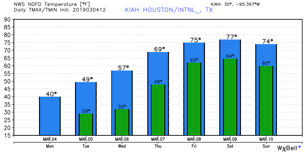
Sunday could be nicer, but it’s hard to say for sure, because the models are split as to whether a front makes it through after Saturday’s showers. So it could be sunny and cooler, perhaps in the low 70s, or it could be cloudy and muggy to start next week. We’ll have to get back to you on that.
Just googled the latest freeze for Houston said it was mid February. So I guess we will be setting a record if it dips below 33.
We for the almost 30 years I’ve been here gotten a freeze between March 1 and March 15 – my friend/neighbor has a birthday in this range and jokes it happens for her birthday.
Not at all true. The record low for March 5 is 25 degrees at Bush IAH. We probably will get down to 28-30 there.
Houston has recorded a freeze at Bush IAH as late as April 10.
https://www.weather.gov/hgx/climate_iah_normals_apr
31 deg. F on April 3rd, 1987, at IAH according to https://www.weather.gov/hgx/climate_iah_normals_apr
Plenty of sub-freezing days in March.
32 deg. F on April 13th, 1940; 31 deg. F on March 27th, 1955, at HOU according to
https://www.weather.gov/hgx/climate_hou_normals_mar
Whoops, 10 April 1973 for IAH.
I know for a fact there was a freeze on April Fool’s day in the 1980s. Had just bought a house and had to run over and turn the heat on.
Do you think this is going to be winter’s last hurrah, or do you think we’ll dip back down into some more 40s and 50s before March turns to April?
We’ll see some more nights in the 40s later this March, but certainly this is probably the last Arctic weather we’ll see for awhile.
And I shall enjoy this weather (and my fireplace) for as long as it lasts.
I live near the Heights, with a peach tree full of baby peaches and a lemon tree in full bloom. Will I lose all of them tonight?
Put 5 gallon buckets full of water next to the tree and cover with a frost cloth or blanket. That will definitely protect the trees and should be enough to save much of the fruit. If unprotected you might lose the fruit and some of the outer branches on the lemon tree.
Can anyone direct me to where I can find historical weather data for a particular location?
I’ve tried NOAA and weather underground but have not had any success.
Thanks!
Are you looking for specific types of historical data, or norms/records? A lot can be found here: https://www.ncdc.noaa.gov/cdo-web/datasets under “Climate Data Online”. Digging further, here’s an example for daily normals: https://www.ncdc.noaa.gov/cdo-web/search?datasetid=NORMAL_DLY
1000s of people lost their homes in Katy during Harvey. I know it’s an old joke, but its really and truly all too real for a lot of people I know.
Hi Jason,
Yes it’s totally tounge in cheek and not about flooding. I have several friends and clients who experienced three devastation that Harvey wrought.
I live in Katy as well and was thankfully spared.
You guys are spot on. A week or two ago you mentioned that there might be a cold snap around the first week of March; IIRC, by March 7th was mentioned. Kudos for accurately predicting that I should keep the cold weather clothing out for use. With the wind chill, it was pretty nippy this morning. I’m not looking forward to the even colder weather tomorrow. Thanks guys; I really appreciate your forecasts.
This may be a bit off topic, but the pollen is in full-tilt-boogy in my Katy neighborhood. The yellow stuff is literally covering everything, and on Saturday I noticed what looks like smoke blowing through the subdivision, which turned out to be (you guessed it), a pollen cloud!
How long will this misery last? Hoping for rain to knock it down
This particular pollen season typically lasts a couple of weeks. Next chance of heavy rain to knock it down comes Saturday.
Buffalo Bayou Regatta is Saturday morning, prepare for storms in the kayak?
Heavy rain and thunderstorms on Saturday — we’re from Los Angeles so we barely know what rain is. We’ll be arriving Hobby Airport at 2 pm on Saturday and driving to NRG Stadium area. Should we worry about road flooding or treacherous driving?
At this point, definitely not.