Whereas they were once consistent, the global forecast models are all over the place in terms of temperatures for the morning of Sunday, Jan. 17th. They range from the mid-20s (Canadian) to low-50s (GFS) in terms of the temperature at start time.
This tells us the models are still having a difficult time handling the timing and intensity of a cold front that will probably arrive shortly before the marathon. In looking at the best forecast model, the European, it calls for temperatures in the upper 30s. However the ensemble members predict a very broad range of temperatures from the low 20s to upper 50s. The highest confidence range is from 32 to 45 degrees.
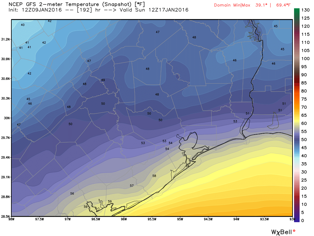
The GFS model has turned warmer for the starting line of the Houston Marathon. But given its lack of consistency I would doubt it at this time. (Weather Bell)
I must caution that we’re still nine days out from the start of the Houston Marathon, but whooboy right now we are setting up for cold conditions. Three of the major global models, the GFS, Canadian and European, all show a fairly strong cold front moving into Houston on the Friday or Saturday before the marathon, with race time temperatures in the low- to upper-30s. That’s right, I would not rule out freezing conditions at the run’s 7 a.m. CT start time Sunday.
This morning I spoke with Joe Bastardi, a meteorologist with Weather Bell whose forecast skills I respect, and he says when it gets cold like this the Canadian model does pretty well, and at this point its the coldest (see attached image). If the front has moved through I don’t think we will have to worry about rainfall, the big concern will be wind chill, even 10 mph at that temperature would make it feel like the 20s during the run.
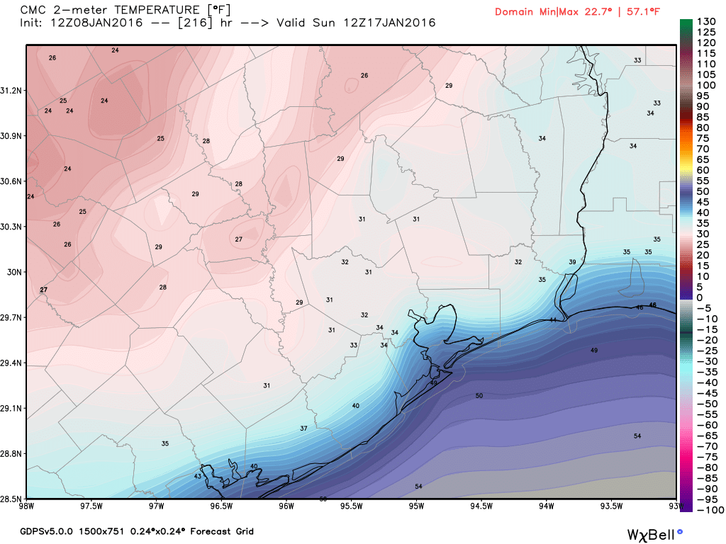
How cold is too cold? Here’s the Canadian model temperature forecast for 6 a.m. Sunday, Jan. 17th. (Weather Bell)
Give yourself a few extra minutes out the door this morning as dense fog is hampering visibility all over the area. A Dense Fog Advisory is posted til 10 AM. Fortunately, we won’t be mired in this weather all weekend.
TODAY/TONIGHT
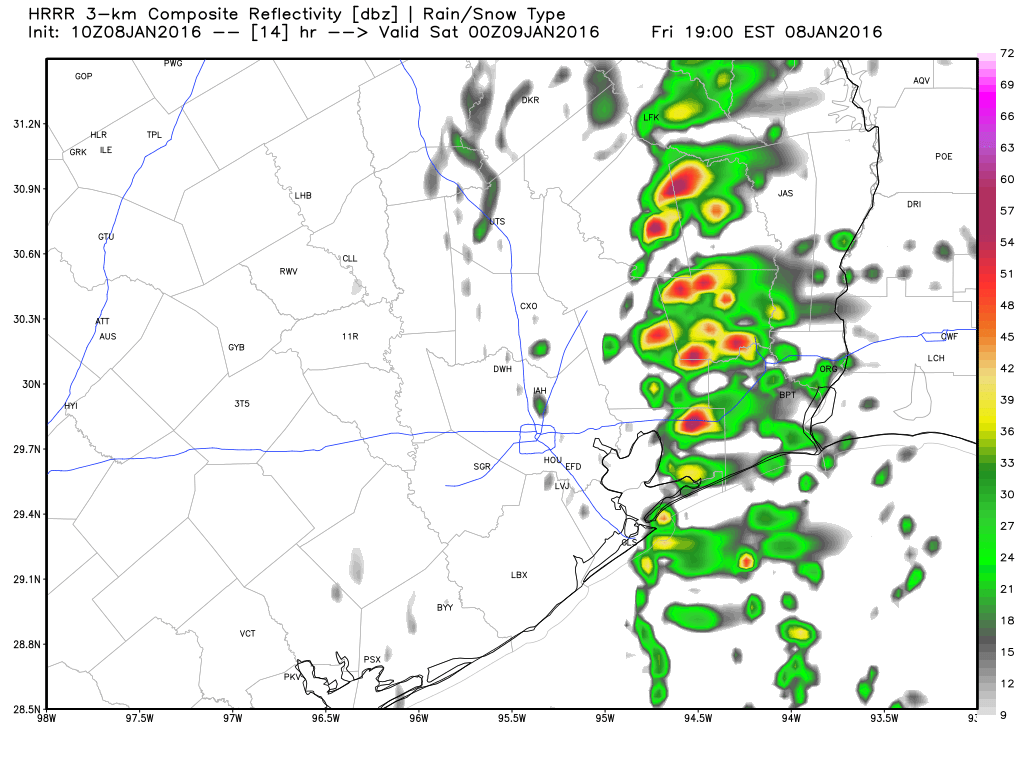
Once the fog dissipates, we should see some sunshine. But our next weather maker is going to plow through here by mid to late afternoon, allowing for clouds and showers to develop. Similar to Wednesday night/Thursday AM, this disturbance will have some vigor to it, so the possibility of thunderstorms is there. These quick moving systems hitting California and then plowing across Texas can surprise with more thunder or rain than expected sometimes. The difference between today and Wednesday night though will be that the majority of this storm won’t get organized until it’s east of Houston, so the heaviest action with this one will be east of I-45 and perhaps mostly in Louisiana. Still, just be alert for some downpours or thunder any time after 3-4 PM today.
Forecast radar for 6 PM this evening shows most activity east of I-45. Still, be on the look out for some downpours later. (Weather Bell)
Hooray! We’re now within 10 days of the marathon so we can at least start to begin to look at global model forecast outputs and not laugh outright. Right now the main difficulty for the marathon forecast is timing the arrival and strength of a cold front before race day.
Here’s how each of the global models handle the front, along with conditions at 7 a.m. Sunday morning:
Canadian forecast model: Front arrives late on Friday, Jan. 15th. By Sunday morning it is cold, with temperatures in the low- to mid-30s. No rain. Sunny with moderate winds.
European forecast model: Front arrives on Saturday, Jan 16th. By Sunday morning temperatures are in the mid- to upper-30s. No rain. Sunny with moderate winds.
GFS forecast model: The front is much less pronounced. By Sunday morning temperatures are in the upper 40s. Sunny with moderate winds.
The Canadian model is COLD. Probably too cold. (Weather Bell)
Looking at the ensembles for the European model, about 80 percent of the members show colder-than-normal temperatures for the morning of the marathon. Just 1 out of the 50 model runs show temperatures 6 Fahrenheit degrees, or more, warmer than normal. This can give us pretty good confidence in at least seasonable, if not cooler than normal, weather for the marathon.
With 10 days to go the precise timing of the front remains a real challenge. For example, if it is slower then conditions on the morning of the race could be warmer (worst case scenario is probably about 55 degrees). A frontal passage during the race would also bring rain. But right now that seems less likely than an earlier passage.