Hot still, but this weekend will bring some relief to Houston

After a couple of brutally hot days—96 and 97 degrees, respectively—we can expect more of the same today. The heat will break a bit later this weekend, however.

FRIDAY

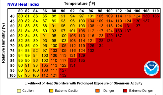
High pressure will dominate again today, pushing highs into the upper 90s with mostly sunny skies. A heat advisory remains in effect due to the very warm weather.

SATURDAY

On Saturday temperatures will again be warm in the mid- to upper-90s, and the heat advisory remains in effect. However as high pressure retreats to the west, some slight rain chances are possible to the east of Interstate 45.

SATURDAY NIGHT through MONDAY

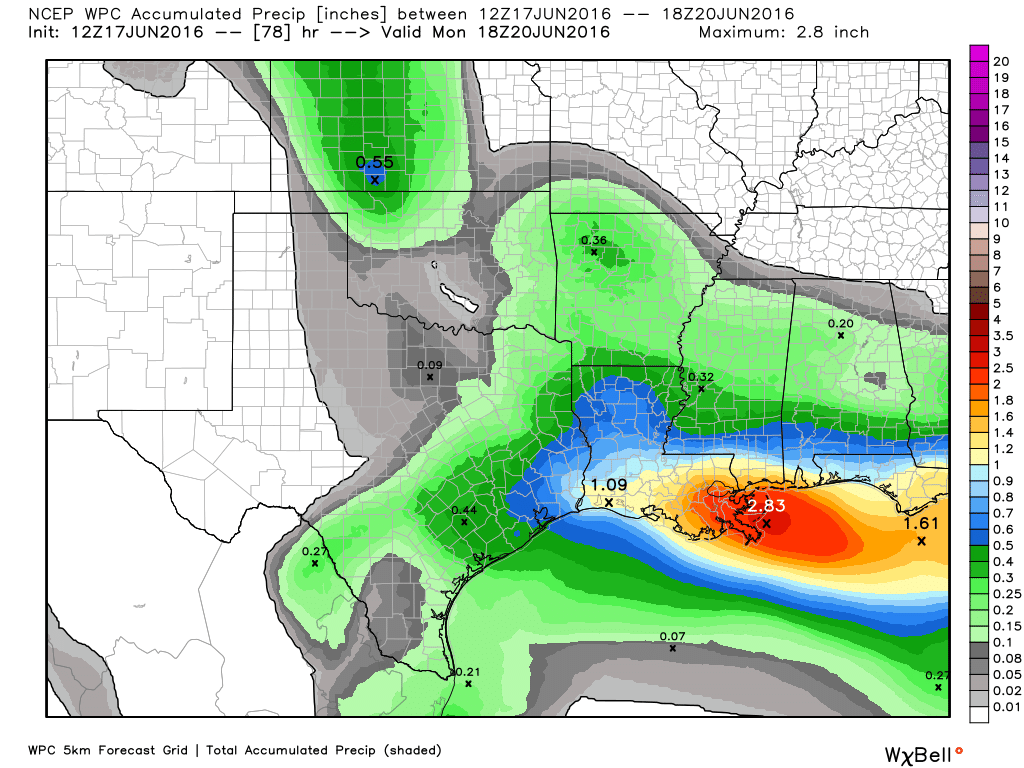
With high pressure weaker, and Houston open to the Gulf of Mexico, we’ll see some better rain chances beginning Saturday night and running into Sunday and possibly Monday. I don’t think we’re going to see any kind of significant flooding, but much of the area may well see one-half to as much as one inch of rain in total, and that will not be unwelcome to the area’s lawns and trees. Some brief, gusty winds are also possible.

NOAA rain accumulation for now through Monday morning. (Weather Bell)

See full post

Heat advisory issued for Houston as very warm weather continues

Good morning. High pressure reigns so it’s going to be hot and sunny. The end.

OK, seriously, that is probably enough of a forecast to get you through the next three days. The National Weather Service has issued a heat advisory for Thursday, and it’s likely to remain in effect through Saturday as high temperatures remain in the mid-90s (we climbed to 96 degrees on Wednesday) with high humidity, pushing the heat index as high as 105 to 108 degrees. Not much more to say other than take care outside in these extremely warm conditions.

SUNDAY-TUESDAY

By Saturday night or so the high pressure driving our weather should retrograde back to the west as a very strong ridge builds over the southwestern United States. This should allow a more northeasterly flow of air into the greater Houston region, increasing cloud coverage and moderating temperatures a bit. Instead of highs in the mid- to upper-90s we’ll be in the low-90s, and overnight lows should be in the mid-70s.

A strong high pressure system will build over the SW United States, allowing air from the northeast to slide into east Texas. (Weather Bell)

See full post

Hot weather continues, and a few words about a tropical system

Good morning. Summer has clearly arrived in Houston when the morning low is about 80 degrees, and relative humidity is above 90 percent. Another feature of summer is possible tropical activity, and you may hear some talk of a tropical storm in the Gulf of Mexico later this week, or during the weekend. But it’s not something I’d be too concerned about as a resident of Texas.

TODAY-SATURDAY

Summer-like conditions continue, with about four more days of highs in the mid-90s, mostly sunny skies, and rain chances near zero. Don’t really need to say more when we’re under this kind of influence from high pressure. Beware of afternoon heat indices near 105 degrees.

SUNDAY-TUESDAY

By Saturday or so the high pressure over Texas should move back west, anchored more over Colorado and the southwestern United States.

A very strong ridge of high pressure over the southwestern United States will bring anomalously high temperatures to parts of the country this weekend. (Weather Bell)
A very strong ridge of high pressure over the southwestern United States will bring anomalously high temperatures to parts of the country this weekend. This is the GFS forecast for temperature anomaly on Sunday evening. (Weather Bell)

See full post

It’s that time of year—so what exactly is the Heat Index?

Here’s the latest edition of Weather whys, a series of posts by Braniff Davis explaining the science behind weather phenomenon affecting Texas.

A reader asked us a great question on Eric’s post this morning about the meaning of a heat index. In a place as hot and humid as Houston, we see meteorologists refer to the heat index all the time, saying things like, “The air temperature is 97 degrees, but the humidity makes it feel like 107 degrees outside.” But what does this actually mean?

With heat indices, there’s a little bit of meteorology—and a little bit of perception. The heat index is an ‘apparent temperature,’ or a measure of how hot air actually feels against your skin. When our bodies sweat, that sweat evaporates off of our skin into the atmosphere. This evaporation of moisture releases latent heat away from the body and, in turn, cools you down. However, when there is already a lot of moisture in the air, the sweat doesn’t evaporate as easily. This makes it harder for our bodies to cool, and therefore, the temperature you feel on your skin is much hotter than the actual air temperature.

HOW DO WE KNOW HOW HOT IT FEELS?

NOAA Heat Index Table

See full post