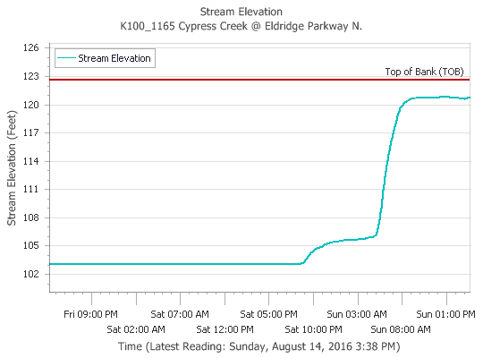
Northwest and northern Harris County have again been the focus of heavy rains this afternoon, and some areas along Cypress Creek have now received as much as 10 inches of rain during the last 24 hours. Fortunately it appears waterways in the area are remaining just within their banks.
After nearly 10 inches of rain Cypress Creek is holding. (HCOEM)
Tropical rains arrived in abundance on Saturday evening across the Houston region, proving that it only takes a matter of hours to go from near-drought like conditions to flooding. The low pressure system that flooded Louisiana on Friday and Saturday, has spread out over east Texas into a broad area of low pressure. At the same time atmospheric moisture levels are extremely high, which will allow for high hourly rainfall rates, possibly in excess of 3 inches per hour in some areas. This all adds up to the potential for ongoing and worsening flooding in Houston.
Today and Monday
The storm system has already flashed its potential this morning by dumping as much as 6 inches of rain to the northwest of Houston, near the Jersey Village area (a flash flood warning is in effect for this area). So far most bayous (including Cypress Creek and White Oak Bayou) are remaining within banks, but they have filled up quickly as the majority of the rain fell within about a three hour period. Fortunately this storm cell is now weakening, but if such an event repeats itself later today over this area, widespread flooding will likely result.
Atmospheric moisture levels are very high this morning. Anything about 2.2 inches of precipitable water is conducive for heavy rain. (Weather Bell)
The much promised pattern change in Houston’s weather is finally at hand.
During the last couple of days a tropical system has completely soaked Louisiana, leading to flash flood emergencies across parts of the state, especially for parishes just north of, and along Interstate 10. Beginning later today Houston is going to see increasing amounts of moisture from this system move into the area, which should set the stage for several wet days.
How much?
It is going to be hard to nail down the particulars of when, exactly, the heaviest rain will come. But it’s safe to say, with a tropical air mass moving into place over the region, heavy rain will be possible most days beginning later today through Thursday or Friday. Not every location will get hit every day, but we should see mostly cloudy weather on most days. After five consecutive 100-degree days, and a 99-degree mark on Friday, we should see highs confined to the upper 80s to lower 90s most days.
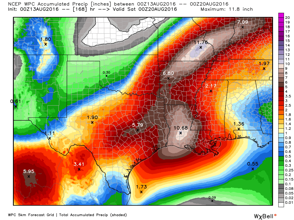
NOAA rainfall accumulation forecast for between Friday night and Thursday. (Weather Bell)
Houston’s on a hot streak and not just at the Olympics! Our streak of 100° days was extended to five on Thursday. We were able to do 6 in a row last summer, and we will come close to matching that streak today. The hot weather in Texas has lead to record energy demand across the state:
ERCOT hourly system #demand tops 71,000 MW for first time. Final prelim is 71,197 MW between 4 and 5 p.m. pic.twitter.com/Ylwel8Hh6H
While no serious weather records are being set with this heat, Texas still sets power records because of population & economic growth. While we should have another scorcher today, as Eric has been talking up this week, cooler temperatures and some good rain chances are coming back our way.
Today
One more day of just a slight chance of a shower or storm, along with continued hot temperatures. A Heat Advisory is once again posted for all of Greater Houston, meaning heat indices will flirt with 110°. Actual temperatures this afternoon will make one more run for 100°, and it will continue to feel very unpleasant. The best chance for showers today will be near the coast and well north and east of the city, but as we saw yesterday, with a quick 1-2″ just outside the West Loop, any isolated shower could produce some heavy rains.
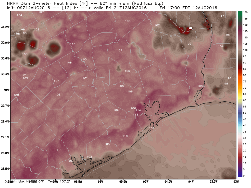
Heat index forecast from HRRR model for 4 PM, shows 105-110° widespread, and even hotter possible in a few spots. (Weather Bell)