The humidity strikes back, but decidedly more pleasant weather is ahead

Welcome back to sticky weather. Lows this morning have only fallen into the upper 70s across the Houston area, and relative humidity is near 100 percent. Expect a few more days of this before some relief this weekend and early next week.

Wednesday and Thursday

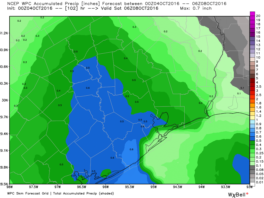
We’re going to continue to see late-summer like conditions as southeast winds bring a warm, moist flow into the region from the Gulf of Mexico. Highs should climb to about 90 degrees, or maybe a tick warmer, with lows in the 70s. The more difficult question is how widespread the rain is. The region will have enough atmospheric moisture to produce showers, but there’s no real forcing mechanism. So I’d anticipate scattered showers both days, primarily during the afternoon hours and most likely along the coast.

Friday

A front should arrive in Houston later on Friday, but the day will still be warm in advance of its passage, with highs around 90 degrees. Expect a dry passage with little or, most likely, no rain. Drier air should allow low temperatures late on Friday night to fall into the upper 60s.

We should see some lower dewpoints by Friday evening or so. (Weather Bell)

Saturday through Monday

It will take some time for the cooler air to work its way into Houston, but we should see more pleasant conditions by Saturday, and especially Sunday and Monday. Highs should fall back into the low- to mid-80s, with low humidity. Low temperatures will probably bottom out on Monday morning, in the upper 50s for inland areas, and low 60s closer to the coast.

Hurricane Matthew

The forecast for Hurricane Matthew, with 125 mph winds, continues to grow more concerning for Florida on Friday and into the weekend. The European model, in particular, has shown the potential for Matthew to strike or significantly graze Florida’s space coast, including the Kennedy Space Center. Already there are mandatory evacuation orders for Brevard County, and the hurricane may pose a significant threat to iconic structures at the space center.

Here are key messages from the National Hurricane Center with regard to the storm.

Posted at 6:50am CT on Wednesday by Eric

Some scattered rains this week before another front Friday

The last vestiges of drier air will move out of the region today, as a more southerly flow reestablishes control over the region’s weather. This is to be expected in October, of course, as Houston is caught between the warmth of the Gulf of Mexico, and periodic cool fronts arrive to bring relief from the humidity. During this work week the humidity will win.

Today through Thursday

Although moisture will return to the area, we’re not going to see the kind of conditions that promote rising air and therefore widespread showers and thunderstorms. While I expect to see some scattered storms, with slightly better chances along the coast, I wouldn’t count on much rain this week (Certainly less than 1 inch, and probably no rain for a lot of the metro area). That is too bad, because a lot of lawns need it. As for temperatures, we’re looking at highs around 90 degrees, with sticky lows in the mid-70s. Not particularly pleasant, but at least these temperatures will be transient.

NOAA rain accumulation forecast for now through Saturday morning. (Weather Bell)

See full post

Some humidity returns before another fantastic weekend ahead

Well, that was nice. Houston’s weekend, with lows around 60 degrees, sure marked a pleasant change from four months of summer. We’ll warm up again some now, but another front before next weekend should make for splendid conditions again.

Today

We’re starting to see a slight rise in moisture levels across Houston this morning, and along with that we’re going to feel some more humidity. Today should be partly to mostly sunny, with highs near 90 degrees as well.

Tuesday through Thursday

Houston will fall back into a more typical early-fall like pattern, with warm days with highs near 90 degrees, and muggier nights, with lows in the low- to mid-70s. With the moisture return we’ll have a chance of some scattered rain showers and thunderstorms, maybe 20 to 30 percent most days, but I’m not expecting anything too extreme.

Precipitable water levels should be highest on Thursday of this week. (Weather Bell)

(Note: Thank you to Innovo IT Solutions for sponsoring Space City Weather in October.)

See full post