No sugarcoating it—Houston’s weather is about to suck for awhile

Good morning. Some isolated showers have moved into the Houston are this morning as a southerly flow returns from the Gulf of Mexico. Hopefully more of the area will see rain later today before high pressure settles in. Either way the heat and humidity is coming back for a good long while.

Today

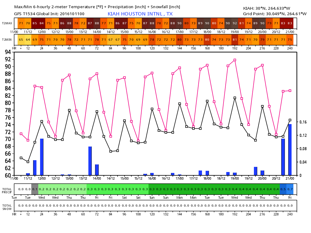
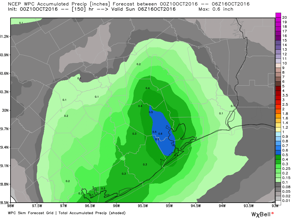
Some of the high-resolution models show pretty decent shower coverage later this morning and during the afternoon hours, as daytime heating develops. Some areas may receive as much as one half to one inch of rain today (others won’t see any, alas), and partly to mostly cloudy skies should limit high temperatures in the mid- to upper-80s. Lows tonight will be in the lower 70s.

Wednesday through Friday

After today we’re going to see higher pressures dominate Houston’s weather for the rest of the work week, and it’s not going to be fall-like at all. Days should be mostly sunny with highs in the upper 80s to possibly even 90 degrees. Overnight lows will be around 70 degrees north of Houston, and in the low 70s in the city and closer to the coast. We can’t rule out some storms on Friday as a cool front moves into northern Texas, but I don’t think the showers and thunderstorms associated with that front will make it all the way to Houston (the front itself won’t, unfortunately).

This is one depressing forecast from the GFS model for the next 10 days. (Weather Bell)

See full post

One more pleasant before … ugh … summer-lite returns to Houston

It’s a beautiful fall-like morning across Houston, with lows in the lower 50s for northern parts of Houston, mid- to upper-50s for much of the rest of the area, and lows even in the upper 60s closer to the coast. Alas, it is not going to last.

Today

We’re going to have one more pretty nice day. Highs today should only reach around 85 degrees, with lows falling into the 60s for most of the Houston area. Drier air will keep humidity levels down. Unfortunately the winds are going to shift back out of the south later today, spelling the return of warmer, more humid weather.

Tuesday

This returning moisture could lead to the development of a few showers on Tuesday, most likely along the coast. Highs under partly cloud skies should remain in the mid-80s, with overnight lows likely back around 70 degrees by Tuesday night.

Wednesday through Friday

Did you miss summer? Because it’s coming back, sort of, with a southerly flow off the Gulf of Mexico. Unfortunately we’re not going to see a return of the rainfall we saw during much of the summer, because that is something we need.

NOAA rain accumulation forecast for now through Saturday. (Weather Bell)

See full post

Refreshing weather to come

After a spike in humidity since Tuesday, more refreshing weather will filter into Southeast Texas today. That will set the stage for what should be a pretty quiet weekend.

Today & Weekend

The cold front discussed this week will finally slide through here today. Humidity should still be a bit high this morning, and areas of fog around the region will lift. As the afternoon wears on, we’ll see humidity drop. By later today, dewpoints drop into the mid 60s in most of Southeast Texas.

HRRR model forecast for 4 PM today shows dewpoints starting to edge back into the mid 60s. It will get better this weekend. (Weather Bell)


High temperatures today will top off near 90 degrees, so it won’t exactly be suddenly beautiful. Saturday will still be a tinge humid, but high temperatures should be a couple degrees cooler.

See full post

One more day of humidity before relief arrives in Houston

Houston’s forecast remains on track, with another day or so of humidity before a front brings drier and cooler air in for the weekend.

Today

One more almost summer-like day lies ahead for Houston with highs near 90 degrees. The ample atmospheric moisture also means we’ll have one more scattered shot at rainfall, which much of the region really needs now after a very dry September and almost no rain in October. Alas rain chances are probably only 20 to 30 percent, perhaps a little bit higher for western areas of the region. Lows tonight will again be warm and sticky.

Friday

We’ll see another warm day on Friday, with mostly sunny skies, but drier air will begin to filter into the area along with a cool front later in the day. Houston won’t see an immediate cool down, but conditions will be nicer by the evening hours, and the front will be more apparent come the weekend. Rain chances are near zero with the front.

Saturday and Sunday

Temperatures have been trending a little warmer for the weekend, but conditions still should be pretty nice for the region. Expect highs in the mid- to upper-80s, with drier air under sunny skies, and lows in the mid-60s, a bit warmer along the coast and cooler up north.

A
Monday should be the coolest morning, with lows 10 to 12 degrees below normal. (Weather Bell)

See full post