After near record warmth in October, a pattern change lies ahead

Happy Halloween! Before jumping into the forecast let’s take a look at what a trick of a month this has been for Houston and much of the southern United States. The following graphic shows the ranking of the average temperature this October compared to more than 100 years of temperature records for this month. Hint: It was warm.

(Eric Blake via Twitter)

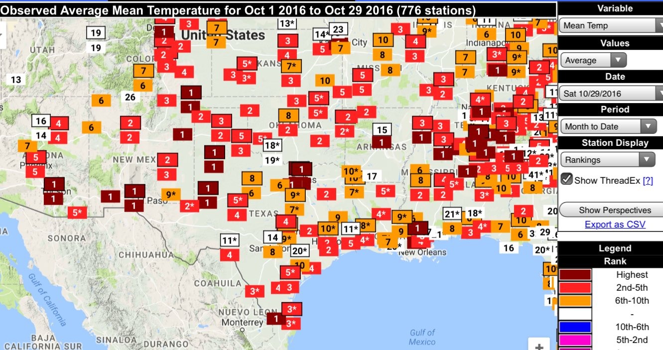
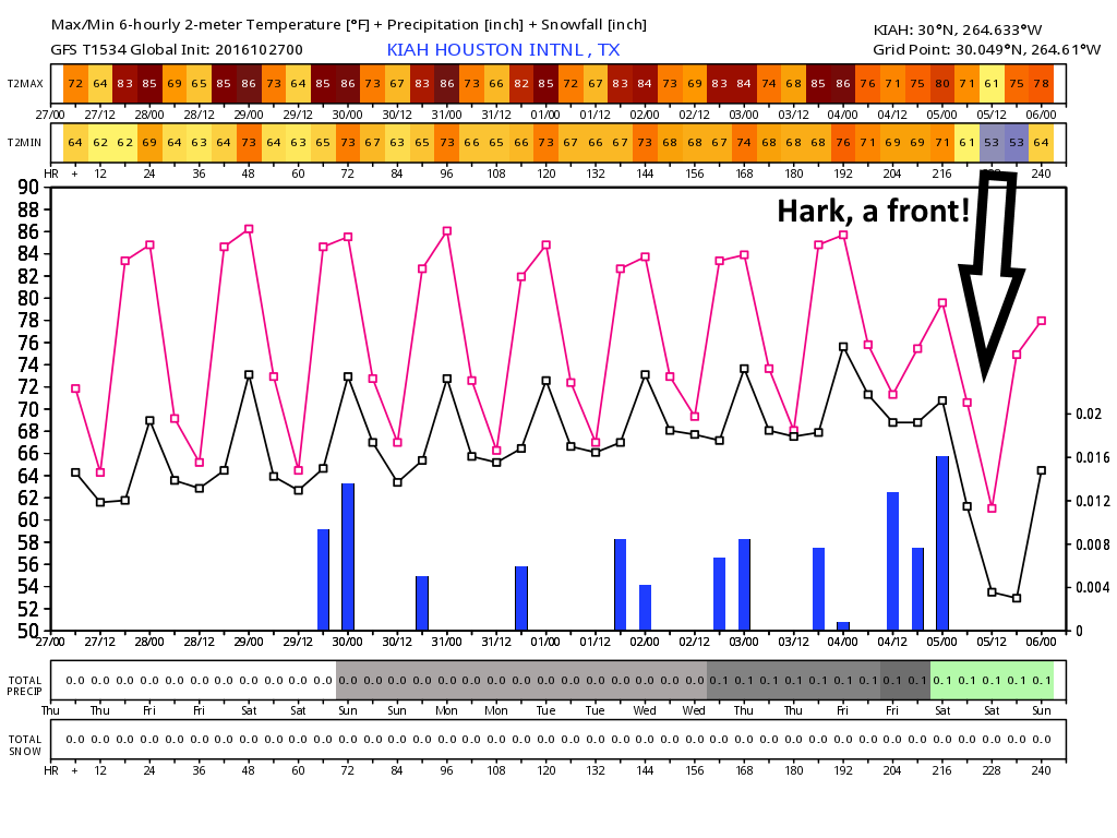
The Houston area has had some sites with the second warmest temperatures, but Dallas, Lubbock, Brownsville, and many other sites are on pace for their warmest Octobers on record. It looks like we’ll have one more warm-ish week before the pattern really does change for good into more fall-like weather.

Today

Houston is under a dense fog advisory until about 10 am CT. With high pressure overhead, today will be another warm, mostly sunny day with high temperatures in the mid- to upper-80s, and overnight lows falling only to around 70 degrees. It won’t be chilly this evening during trick-or-treating, but it won’t be particularly unpleasant, either. Rain chances will be near zero.

Tuesday through Thursday

As high pressure moves off moisture levels will increase over Houston. This will accomplish several things—we’ll see more clouds, which should limit high temperatures to the low 80s, and after an extremely dry October we might see some rain showers to start off November.

The rain accumulation forecast for this week shows the best chances to the southwest of Houston. (Weather Bell)
The rain accumulation forecast for this week shows the best chances southwest of Houston. (Weather Bell)

See full post

Houston’s official trick-or-treat forecast for Halloween

We’re fast coming up on Halloween and I’m happy to report that we’re not going to face the kind of uncertainty we did in 2015, when Houston was in the midst of widespread rain storms that threatened to ruin Halloween. (We got soaked in my neighborhood in Clear Lake).

Rain chances aren’t zero this year, because the onshore flow will resume in force on Monday, which should further increase humidity levels for the region. This could produce some isolated showers for coastal areas, but I don’t expect any widespread issues. Right now it looks like rain chances will improve on Tuesday and Wednesday.

A Halloween scene at the Zoo Boo. (Photo by Jason Cross/Flickr)

See full post

Spooky quiet heading into the weekend

Alright, so it isn’t spooky quiet per se, but I wanted to get the spirit of Halloween in this post. It’s quiet in the weather department around Houston. It really hasn’t been so bad lately, though I think a good bit of us would prefer some slightly cooler temperatures. We may get our wish later next week.

Drought update

First off, Eric talked earlier this week about drought returning to Texas. Indeed it has. Yesterday’s Drought Monitor update showed coverage of moderate (D1) or severe (D2) drought nearly double in Texas from 5.9% last week to 10.8% this week.

After a dry month or two, coverage of drought is expanding in East Texas. (US Drought Monitor)


Most of this is in northeast Texas east of Dallas. But the area around Southeast Texas has grown also, with areas just east of the city and much of Waller, Austin, Colorado, and Lavaca Counties now in moderate drought. Even with some rain chances next week, total rainfall continues to look a bit sluggish in our region, so I expect we’ll see this dry weather maintain its grip on much of the state.

See full post

A cool front finally shows up on Houston’s horizon

Houston’s forecast remains largely unchanged. As with some previous mornings, calm winds and cooler grounds will lead to the development of some radiation fog this morning and likely through the weekend. A front remains several days off.

Today and Friday

With high pressure off to the west and easterly winds, we’ll continue to see warm but not unpleasant days with highs in the mid 80s, and nighttime temperatures in the 60s (down near 60 degrees north of Houston, and upper 60s along the coast). Skies will remain mostly sunny.

Saturday and Sunday

High pressure moves closer to the Houston region, so we may see temperatures tick up a degree or two, but I’d still anticipate highs in the mid-80s for the most part with lows in the 60s.

Halloween

We’ll start to see more moisture moving into the Houston area on Monday, and this could lead to the development of a few scattered showers later during the day. I wouldn’t worry about anything too disruptive for trick-or-treating, however. Highs, again, in the mid-80s. Temperatures during the trick-or-treating hour will likely be in the mid- to upper-70s.

Ten-day forecast from the GFS model. (Weather Bell)

See full post