After three record highs, Houston finally cools off

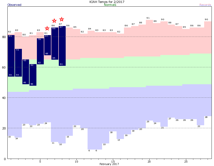
What start to the week it has been—three consecutive 80-degree days, and three record highs. Overnight lows, too, have been anomalously warm. Here’s what that looks like in graphical form, with this month’s temperatures plotted against normal levels.

(National Weather Service)

After a cold front the region will see a bit of a reprieve from the heat, but we’ll warm back up this weekend before more seasonable temperatures return next week.

Today

After a cold front moved through on Wednesday, conditions for Thursday will be splendid. Highs should reach into the upper 60s with mostly sunny skies. Lows tonight will fall into the low 50s for most of Houston.

Friday

After a cool start, Friday will warm into the low- to mid-70s as winds begin to swing out of the southeast. This should allow for some clouds to return as well.

Saturday and Sunday

As the onshore flow resumes the region should see a partly sunny weekend, with highs in the upper 70s—some areas will probably hit 80 degrees if it stays sunny enough during the afternoon hours. Beginning on Friday night there will be enough moisture to squeeze out a few scattered showers throughout the weekend, but accumulations should be very slight.

(Space City Weather is sponsored this month by Darrell Lee’s The Gravitational Leap)

See full post

After breaking all kinds of heat records, Houston eyes some relief

Houston set all kind of heat records on Tuesday:

  • Intercontinental Airport reached 86 degrees, breaking the old record of 80 degrees
  • Hobby Airport reached 85 degrees, breaking the record of 82 degrees
  • Galveston reached 80 degrees, breaking the record of 76 degrees
  • It was the earliest 80 degree day for Galveston on record, breaking the previous record by two weeks—Feb. 21 set back in 1993.

There’s more to come today before we cool down a bit for the west of the week.

Today

Some dense fog along the coast will give way this morning to a mostly sunny—and for February, extremely warm—day. The earliest 90-degree day on record in Houston is Feb. 20 (1986), and while I don’t think we’ll reach 90 degrees, I’m not entirely ruling it given what happened Tuesday. Highs should be in the mid-80s regardless before a cool front arrives sometime this afternoon, pushing lows on Thursday morning into the 50s.

The GFS model predicts a front will push into northwest Houston by around noon today. (Weather Bell)

(Space City Weather is sponsored this month by Darrell Lee’s The Gravitational Leap)

See full post

Houston close to having the most 80-degree days during a winter

After Houston reached 81 degrees on Monday (tying a record high set in 1911), the city has now recorded 12 days with high temperatures of 80 degrees, or warmer, this winter. According to the National Weather Service, the record for total number of 80-degree days in “winter,” defined here as December through February, is 17, which has happened three times (1995-96, 1956-57, & 1910-11). We’re likely to pick up at least two more 80-degree days this week, so that will put us at 14. I’d give us even odds of breaking the overall mark.

Tuesday and Wednesday

If you liked “winter” on Monday in Houston, you’re going to love the next two days. A strong southwesterly flow of warm, dry air from Mexico will bring a surge of winter heat into the region.

Expect drier, less humid air today and Wednesday across most of Texas. (Weather Bell)

I’m anticipating high temperatures of around 85 degrees on both days, with partly to mostly sunny skies. Lows will fall to around 60 degrees. As drier air mixes down, fire conditions will increase so take care of sparks.

(Space City Weather is sponsored this month by Darrell Lee’s The Gravitational Leap)

See full post

For Houston, “winter” is probably over

It’s yet another one of these non-winter mornings across Houston, with low temperatures of around 70 degrees. It’s enough to make one wonder whether the region will get through this winter without a prolonged cold spell, and I’m increasingly confident the answer is yes. We might be done with freezes, as well.

For most of central and southern Houston and Harris County, the average last freeze date falls in mid-February. It’s not going to freeze again before then, and by extension I’d be confident in planting from here on forward. For areas north of there, including Montgomery County, the freeze date is generally later, in the latter part of February or early March. Even so, I’d bet the chances of another freeze for the greater Houston metro area this year, including areas like Montgomery County, is now significantly less than 50 percent.

Finally, here’s a tidbit about Dallas’ winter from Victor Murphy, of the National Weather Service—February 5 is date of the earliest last freeze in Dallas-Fort Worth. The average date of the last freeze is March 13. It’s possible this year that the city’s last freeze of winter will have come all the way back on January 8th.

(Space City Weather is sponsored this month by Darrell Lee’s The Gravitational Leap)

See full post