Enjoy Friday, as Houston gears up for a stormy late weekend

After our wild Wednesday, we were treated to absolutely gorgeous weather yesterday in Southeast Texas. That will lead to another winner of a day today, albeit warmer. We continue to watch the weekend however, and the chance for both severe weather and heavy rainfall. Here’s the stormy breakdown.

Today

No weather trouble at all today. Expect ample sunshine, warm temperatures, and a breeze. We should make it into at least the middle 80s for high temperatures after a pleasant start this morning. Humidity will gradually work its way back ashore later today and tonight, but the majority of the day should feel pretty comfortable. That said, tree pollen (oak and cedar) remains high despite recent rain, and both grass pollen and mold spores are high also. So if you’re an allergy sufferer (raises hand), we still have a ways to go.

Quick cool thing I wanted to share. Here’s a satellite loop over South Texas this morning from the new GOES-16 satellite that was launched last November. This is experimental and non-operational data, as they’re still doing fine tuning, but check out how many lakes and different bodies of water you can detect on the satellite even at night.

Lakes and other bodies of water show up amazingly clear on a clear overnight in Texas. Experimental, non-operational data. (College of DuPage)

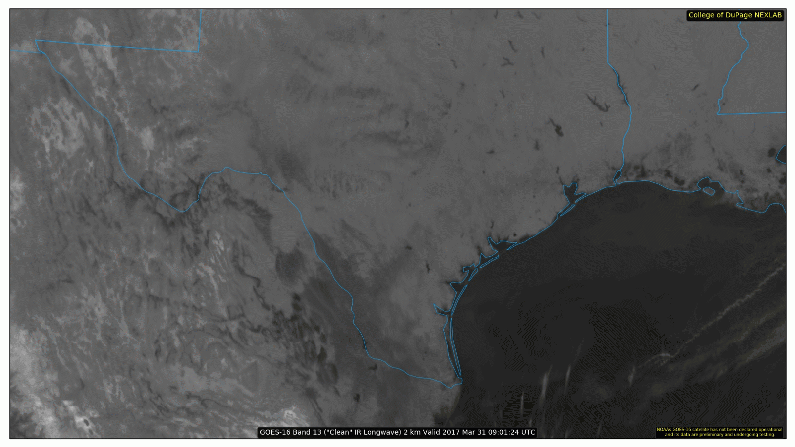
Amazing difference, and it’s like going from a clunky box of a TV to an HD set for meteorologists.

Saturday

The forecast gets a little trickier Saturday. Humidity will continue to flood ashore through the day. I expect we’ll see increasing clouds after a fairly sunny start. The last couple days it’s looked close for perhaps a few storms as early as late Saturday afternoon. Recent model data limits those chances until late evening. So while I think we’ll be dry during the day and early evening Saturday, if you’ll be heading up to the Shell Houston Open or to the Dynamo/Red Bulls match or Whatever Fest east of Downtown, just be aware later in the day in case it does get stormy.

(Space City Weather is sponsored this month by an anonymous donor)

See full post

Pleasant today in Houston, but heavy rains and storms likely return Sunday

A cool front moved into the Houston area during the overnight hours, and this will bring us a brief spell of slightly cooler air before conditions warm up again this weekend. We’ll also have to watch for the return of storms and widespread, heavy rain on Sunday.

Today

Winds are blowing out of the northwest this morning, and could gust up to about 20mph later today. Even after skies clear out we should expect high temperatures only to rise into the upper 70s today—alas there won’t be too many days this cool again until late next fall. Lows tonight should fall into the upper 50s for the northern half of the Houston area, and to around 60 degrees closer to the coast. Enjoy the drier air.

Friday

After a cooler start on Friday morning, conditions will quickly warm under mostly sunny skies. Look for high temperatures in the mid-80s across Houston. I think some areas further inland, such as College Station, could see highs in the upper 80s although I don’t think they’ll quite make 90 degrees. Lows Friday night will be 5 to 7 degrees warmer than Thursday.

(Space City Weather is sponsored this month by an anonymous donor)

See full post

Strong thunderstorms moving into Houston Wednesday morning

Good morning. The big concern today is a line of strong thunderstorms moving into metro Houston this morning from the west. As of about 6:30am CT, the leading edge of the main line of storms was located at Schulenburg.

Location of severe storms as of 6:35am CT on Wednesday. (Intellicast)

These storms will advance into Houston later this morning, likely reaching western parts of the metro area between 7 and 9am CT and moving into the central Houston area by 8 to 10am. The main threats from these storms include damaging winds (gusts of 40mph or greater), heavy rains, and possibly some tornadoes. As these storms have moved across central Texas they have produced a large amount of lightning, and briefly torrential rain has caused some short-lived street flooding.

Fortunately, the storms are moving to the east at a good clip, may weaken a bit as they approach the coast, and should pass through most areas in about an hour. After the main line moves through this morning, some additional, lighter rain may linger across parts of Houston this afternoon and evening, before a cold front moves through tonight. This should lead to briefly cooler weather on Thursday—it’s going to be a spectacular day, plan to spend some time outdoors if possible—before we warm up again heading into the weekend.

After sunny conditions Saturday, we’ll again have to watch for the possibility of heavy rain on Sunday, although models have backed off some of their extreme predictions. I’d still expect a solid 0.5 to 1.5 inches of rain on Sunday and Sunday night for the metro area, and conditions will again be in place at least for the possibility of some severe thunderstorms.

Posted at 6:45am CT on Wednesday by Eric

Heads up Houston: Storms Wednesday, water hazards Sunday

Good morning. We have some potentially dynamic weather to talk about for the week ahead, with the potential for storms and heavy rain, so let’s get right to it.

Today

Conditions will be fairly pleasant for Houston today, with partly to mostly sunny skies, and highs in the low 80s. The only blemish will come from gusty southerly winds, bringing moisture in from the Gulf of Mexico, and blowing up to about 20mph. Lows will again be very warm for March tonight, only falling to around 70 degrees for most of the region.

Wednesday

As we’ve been discussing, a potent upper-level storm system will sweep across the central and southern United States on Tuesday and Wednesday, generating enough lift and instability to produce some potentially severe weather. Timing remains a little unclear, but right now storm development in Houston seems most likely during the late morning or early afternoon, and running through the evening hours on Wednesday. NOAA’s Storm Prediction Center favors the northern half of the metro area as most likely to see development.

NOAA storm outlook for Wednesday. (NOAA)

See full post