Tonight, Houston may be as cold as it’s been in late May in 20 years

The Houston region received some much needed rainfall over the last couple of days, with generally 1 to 4 inches falling over the metro area. We were fortunate that the showers and thunderstorms delivered the rain not in a deluge but—for Houston—a more steady event. I have some visitors in town from Los Angeles, and they commented on how hard it rained Monday while driving through Houston. I had to inform them that this was pretty common in our city, and certainly not flood inducing. After Monday’s showers we can now look ahead toward some great mid-week weather with a strongish cold front tonight.
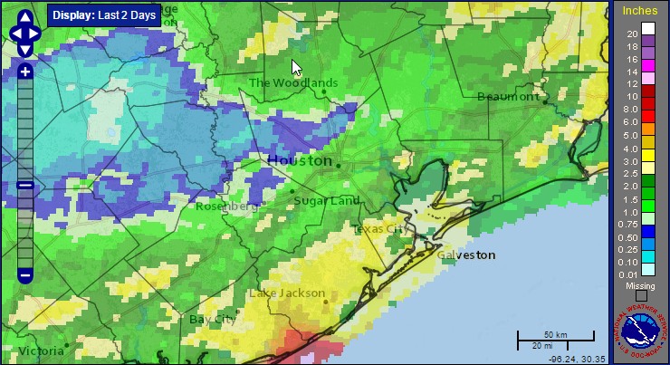
Accumulated rainfall for the period for the 48 hours preceding Tuesday morning. (NOAA)

Tuesday

Temperatures are in the upper 60s across the Houston area this morning, and with a slight northerly wind it is not unpleasant. Conditions are going to be even more pleasant tomorrow. That’s because a stronger front (for May) will move through later today. This will bring a chance of showers, and a slight chance of severe weather (mostly high winds) during the afternoon and evening hours. For the most part rain accumulations should be a few tenths of an inch, if that, and should end by late this evening.
See full post

Storms moving into Houston this morning, clearing later

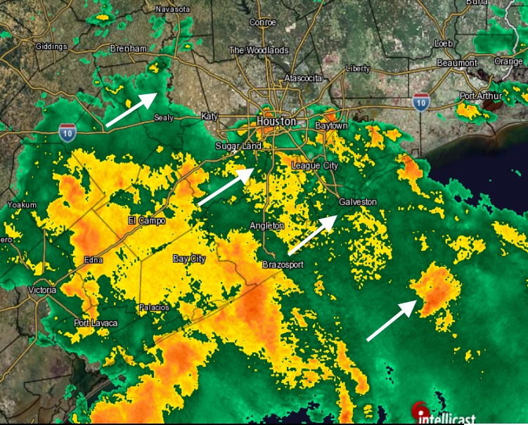
As anticipated, widespread showers and thunderstorms have moved into the Houston area this morning, particularly affecting the coastal regions. Due to the storms, the southern half of the metro area is under a flash flood watch through 1 pm.

Monday

As an upper-level disturbance moves in from the southwest, it is combining with high atmospheric moisture levels to continue to bring a healthy chance of rain into early afternoon hours. However, the large cluster of storms is moving slowly to the east, and therefore should clear the area by some time this afternoon.

Storms moving into Houston as of 6:40am CT. (Intellicast)

For the most part, given our relatively dry ground, rainfall amounts should be quite manageable—1 to 3 inches along the coast, with lesser amounts for inland areas today. We’ll have to be concerned about the possibility of some locally heavier rainfall, but so far these storms have been manageable. Highs should be around 80 degrees.

Tuesday

Rain chances drop off Monday night and Tuesday morning, but then a late-season cool front will move through the region sometime during the day. This front will bring enough instability to produce some scattered showers and potentially thunderstorms (very slight chance of severe weather) later on Tuesday. Rain accumulations will certainly be less than today, and areas that see rain probably will only see a tenth of an inch, or two.

(Space City Weather is sponsored this month by Jetco Delivery)

See full post

Heavy rains likely coming to Houston tonight and Monday

After mostly dry weather for the last six weeks, Houston’s weather will turn more dynamic later today and Monday. Three factors will help drive the potential for heavy rain during the next 36 hours: high atmospheric moisture content, a stalled front, and an upper-level system moving into the region from the southwest.

We don’t have too many concerns about weather today—as any showers and thunderstorms that develop probably won’t be too organized, and any strong storms should move through the region for the most part. Expect partly to mostly cloudy skies and highs in the upper 80s with a decent chance of rain. Accumulations will likely be less than 1 inch for most areas.

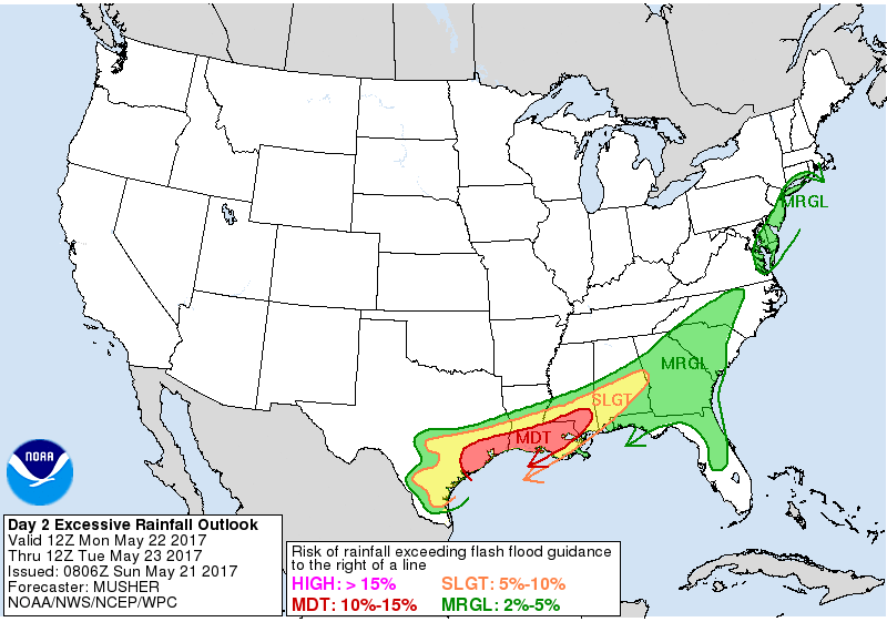
The bigger potential for storms will come later tonight and Monday, as an upper-level disturbance moves into the region. For now it appears the best rain chances will be closer to the coast, but I think most of the area has a good chance of seeing 2 to 4 inches of rain through Monday night. Because the atmosphere is so moist, we’re likely going to see higher localized amounts where the heaviest storms develop on Monday, but it’s just not possible to predict where those bullseyes will occur. Some flash flooding is therefore possible.

The Texas and Louisiana coasts face a moderate risk of seeing flash flooding tonight and Monday. (NOAA)

The bottom line is we’ll need to pay close attention to weather conditions tonight and on Monday. Lesser rain chances remain Tuesday, whereas from Wednesday on the weather looks great. We’ll stay on top of things for you.

Posted at 10:15am CT on Sunday by Eric

At least some welcome rain this weekend

Rain has come at a premium in recent weeks, with only about a half inch officially at Bush Airport over the last 30 days. This weekend will likely see us add to that, but probably not in too big a fashion.

Today

No issues today. Yes, there may be a couple showers around this afternoon, especially east of I-45, but none should be particularly significant. So if you have outdoor plans today, it would be good to have an umbrella handy, just in case you briefly need it. Odds are you won’t have to open it though. Temperatures will likely top off around where they did yesterday, the upper-80s to low-90s. Galveston has yet to drop below 80° this morning and is likely to set or tie both another record high and record warm minimum temperature today.

Saturday and Sunday

If you have outdoor plans this weekend, I think the best advice is to just have an umbrella. You’ll probably need it at some point, but not most of the time.

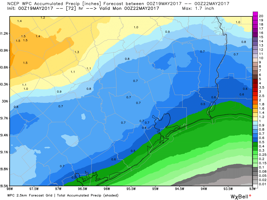
Both Saturday and Sunday afternoons will likely have some rain and storms in the area. I think the better chance of widespread storms is Saturday overnight into Sunday afternoon. Most folks should see at least some rain, but only a few areas will see heavy rain. Average rain totals this weekend should be around 0.5″, but a few places will likely see one or two inches of rain and others less than 0.5″.

Total rainfall through Sunday evening should be manageable. The best chance for widespread rain is late Saturday night through Sunday afternoon. (Weather Bell)


High temperatures should max out a couple degrees cooler than yesterday and today, with mid to upper 80s (perhaps near 90° Saturday with enough sun). Overnight lows will be in the mid to upper 70s. You may notice slightly more comfortable weather later Sunday, but it won’t be anything to get too excited about.

(Space City Weather is sponsored this month by Jetco Delivery)

See full post