After a super hot weekend, a surprisingly cool start to August

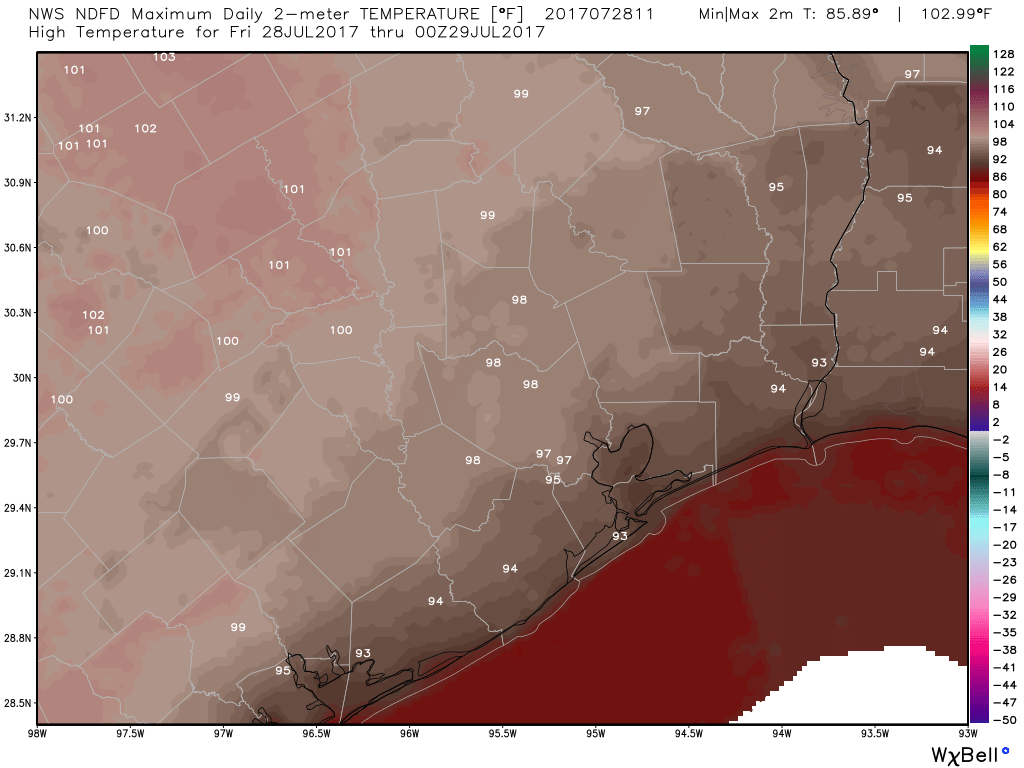
Houston was promised a hot weekend, and Houston got a hot weekend. Here are how temperatures ended up at the major weather sites in the Houston area. Of note, the city’s official station at Bush IAH recorded its first 100-degree day of the year, and Hobby Airport set a record high on Saturday, breaking the old mark of 100 degrees set in 2015.

Weather site Friday Saturday Sunday
Bush Intercontinental 99 degrees 100 degrees 96 degrees
Hobby Airport 100 degrees 102 degrees 97 degrees
Galveston 91 degrees 93 degrees 91 degrees


But then a funny thing happened. A rare late July front slogged through the area on Saturday night and Sunday, and this morning nearly all of the region is seeing demonstrably drier air.

Today

With sunny skies we’ll see high temperatures reach the low- to mid-90s today, but with low humidity this evening should feel quite pleasant. Lows tonight will be in the 70s.

See full post

Houston’s highest heat of 2017 upon us

Thursday was the hottest day of 2017 to date. Hobby Airport hit 99°, tying a record last set in 1965, while Bush Airport officially hit 98° on Thursday. Friday has a chance to equal or top it, but there is some good news.

Today and Saturday

Simply scorching. High pressure remains on top of Texas. This will both limit rain chances and maximize temperatures today. Expect temperatures very near where they were on Thursday, with highs in the upper 90s to near 100° in and around Houston. Minimal relief at the coast, with Galveston through Matagorda seeing highs in the low-90s Friday afternoon.

A scorching map of NWS forecast high temperatures for Friday. (NWS/Weather Bell)


There won’t be too many showers around today, but as we saw on Thursday, you could conceivably get one or two that pop up in parts of the area (most likely south of I-10) and dump a couple inches of rain in a short time. But the majority of the region will stay dry.

Combined with a bit of humidity, it will again feel uncomfortably hot today. Heat advisories are unlikely, but regardless, you should take it easy outside today and tomorrow.

It’s always a good idea to review some heat safety tips. (NWS Houston)


Saturday will be similar, although the chance of showers may be just a tick higher, but temperatures will be fairly close to where they end up today. The best chance of showers will be east of I-45 and in Louisiana on Saturday. Still, a handful of downpours may occur around the Houston area Saturday afternoon or evening, and storms east of Houston could be a bit on the strong side.

See full post

Very hot to end the week in Houston, surprisingly temperate next week

Houston has yet to have a 100-degree day this year. Some summers we get lucky, such as in 2014, when the mercury never got that high. Sometimes we get more. For example, during the ridiculously hot summer of 2011 every day but one during the month of August had a high of 100 degrees or higher. The average high temperature that month was a staggering 102 degrees.

This summer won’t be nearly so hot, far from it, but the Houston region has a slight chance to hit 100 degrees today and Friday at its official weather station, Bush Intercontinental Airport, today and Friday before things cool off a bit.

Thursday and Friday

Houston will lie on the edge of high pressure to end the work week, and this will allow for mostly sunny, and hot days. While I won’t rule out a few stray showers, for the most part we’ll be dry, with highs reaching the upper 90s—and possibly 100—for inland areas, and lower to mid-90s closer to the coast.

High temperatures are likely over central Texas to end the week. But will they move as far east as Houston? (Weather Bell)

See full post

High heat this week in Houston, a bit cooler next

Houston’s weather will remain hot for a few more days as the region flirts with high pressure, but as we head into August it doesn’t look as though the region will immediately fall under a classic “ridge of death” that stifles rain chances. Quite the contrary, later next week could be fairly wet and a bit cooler.

Today

Moisture levels have jumped back up today, and we’re likely to see at least some scattered showers this afternoon across the area. I think it’s even possible that most areas will see some light to moderate rainfall, but I wouldn’t bet on that. In any case, more clouds should hold temperatures in the low- to mid-90s.

Thursday and Friday

High pressure builds in somewhat, and this should limit shower activity and bring out the sunshine. I’d expect highs to jump up accordingly, into the mid- to upper-90s. Either of these days could bring temperatures of 100 degrees for inland areas, so be prepared for the heat.

See full post