The two tales of Harvey—first winds, then lots of rain

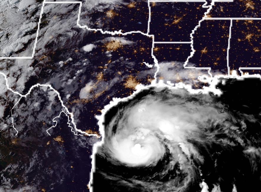
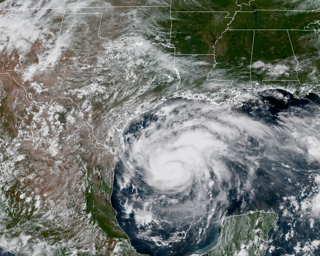
Good morning, everyone. After an overnight lull in strengthening, perhaps caused by some dry air working its way into the circulation of Hurricane Harvey, the storm has begun intensifying again. As of 6am CT it had sustained winds of 110 mph, but with the central pressure continuing to fall, the storm’s winds will almost certainly increase. For Texas, there will be two epochs of Harvey: the catastrophic effects from wind and surge during the next day or so for the central Texas coast, and the unfolding, widespread, major flood event from Saturday through the middle of next week for a large swath of the state, including Houston. We will discuss both this morning.

Wind and Surge

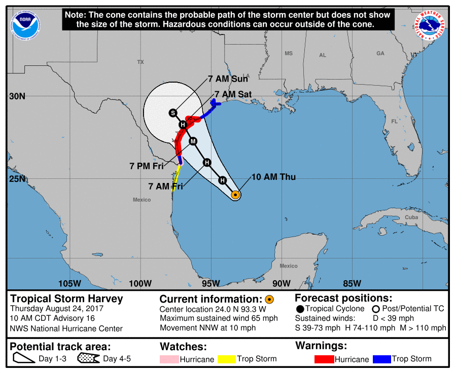
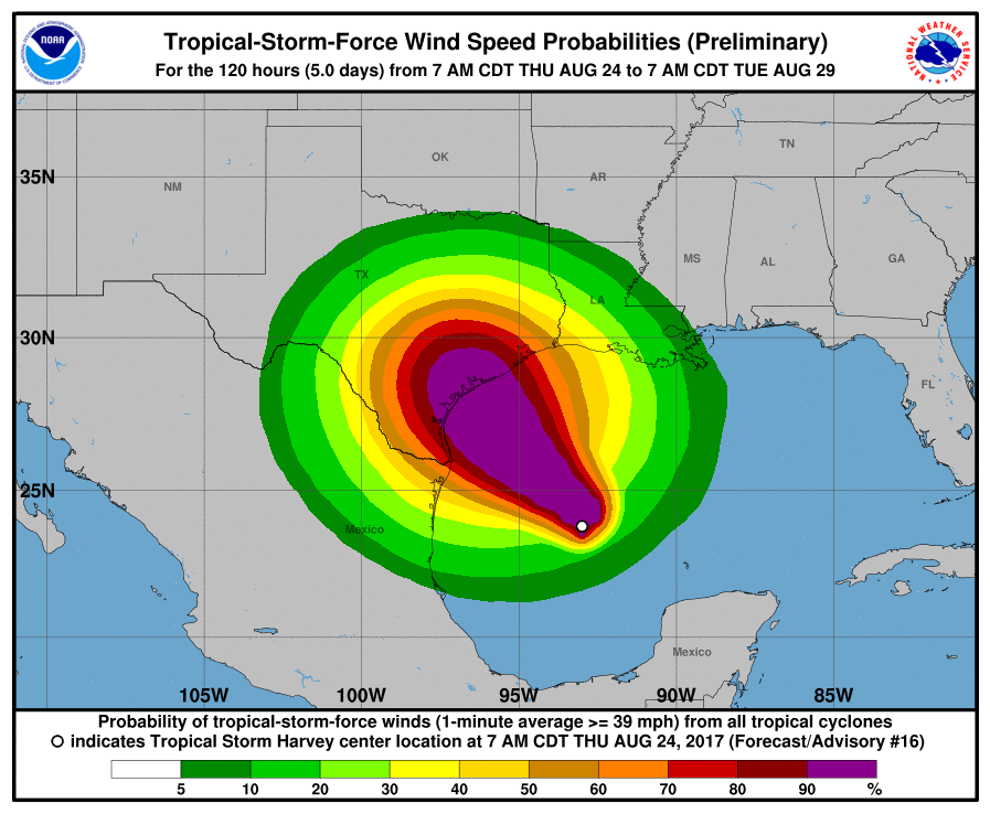
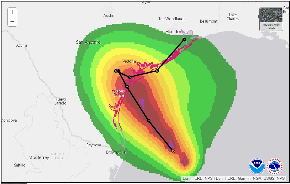
We remain confident in the forecast track for Harvey during the next 24 hours, as it moves northwest across the Gulf of Mexico, and comes ashore somewhere near Port Aransas. If you live in, or have property from Rockport to Matagorda, preparations for devastating winds—probably about 120 mph sustained, but maybe higher—should be completed by early this afternoon.

National Hurricane Center forecast track at 4am CT, with probability of hurricane force winds (red high, green low). Also storm surge warnings are shown in red markings along the coast.

Storm surge will be a major problem for low-lying coastal areas. According to the latest National Hurricane Center storm surge forecast, the following numbers represent the realistic “worst case” inundation. This means the depth of water above the ground. You can visit the site itself to zoom in to any location along the Texas coast.

  • Mustang Island to Sargent, including Matagorda Bay: 6-12 feet
  • Sargent to Jamaica Beach: 5-8 ft
  • Jamaica Beach to High Island: 2-4 ft
  • Galveston Bay (Seabrook, Shoreacres, Nassau Bay, Kemah, San Leon) 2-4 ft

For Houston, aside from the above surge numbers, the effects from the immediate landfall of Hurricane Harvey will be relatively modest. As we’ve discussed, winds Friday night and Saturday morning should be manageable, although some areas may briefly see some tropical storm-force winds. The power grid is designed to withstand these conditions—so hopefully most of us will keep the lights on.

See full post

Harvey late night: Some final Thursday thoughts

As of 8:00pm CT tonight, a well-organized Hurricane Harvey is moving northwest, toward the Texas coast. It packed 85-mph winds, but forecasters at the National Hurricane Center still expect it to come ashore late Friday night, or Saturday morning as a major hurricane. The most likely landfall location is between Corpus Christi and Port O’Connor. The storm’s strong winds and storm surge, likely at least 10 to 12 feet above normal tide levels, will pack a punch along the central Texas coast. For people in low-lying areas from Corpus to Freeport, these are potentially life-threatening conditions, and I urge you to heed the warnings of the Corpus Christi National Weather Service office and local officials.

For tonight’s post I wanted to discuss the most likely scenario for immediate effects in Houston, and then reconsider the uncertainty about what comes next. The National Hurricane Center anticipates that sustained winds on Friday night and Saturday morning in Houston and Galveston have about an 80 percent chance of reaching 39 mph, or greater. I think that’s possible, and certainly chances are higher southwest of Houston, in places like Sugar Land. However, at this point the available model data indicates that winds will be manageable in the Houston region during Harvey’s landfall. This is important for a number of reasons, not the least of which is that minimal tropical storm force-winds are something the region’s power grid should be able withstand. Mostly.

Harvey’s satellite appearance at 8pm CT Thursday. (NOAA)

In terms of rainfall, the picture is more grim. It still appears as though the Houston region will see manageable rainfall totals through most of Saturday. That is not to say it won’t rain hard at times, and streets may briefly flood. But for the most part I don’t expect mobility to be greatly impaired. If this forecast changes, we will of course be all over it.

Now, looking ahead to the period of Sunday through Wednesday, uncertainty in the track forecast reigns. We’ve hammered this point for a couple of days, but the point remains that we can’t be sure where the storm is going to go after it reaches the coast. It’s like putting a bowling ball down in the middle of an alley—where will it roll? Harvey is going to be something like that. And unfortunately, for us to really get a good, solid handle on rainfall, we ultimately need to know where the center is going to go. Perhaps the best way to handle this is to spitball some probabilities. So let’s discuss three different scenarios.

See full post

Thursday afternoon: Hurricane Harvey rapidly strengthens, nearing Texas

We are now about 36 hours from the landfall of Hurricane Harvey, which is taking advantage of 87-degree waters in the Gulf of Mexico to intensify today, and may continue to do so right up until landfall late Friday night or Saturday morning. The rapid intensification we’ve seen today (as of 1pm Harvey had sustained winds of 85 mph) is the reason why meteorologists are so watchful of tropical lows in the Gulf during August and September—in the absence of wind shear, the bath water out there is highly favorable for storms to strengthen.

Harvey has transformed from a tropical depression into an impressive hurricane in less than 24 hours. (NOAA)

Today’s strengthening, and increasingly bullish model forecasts for intensity, have caused the National Hurricane Center to increase its predicted wind speed for Harvey’s landfall to 125 mph, just shy of Category 4 hurricane intensity. Although intensity forecasts are imprecise, it seems safe to conclude that a powerful hurricane will be coming to the Texas coast soon.

With a stronger storm, we need to be more concerned about the landfall location. Confidence continues to increase in a landfall between Corpus Christi and Port O’Connor. This obviously will have big implications in terms of wind and storm surge for Corpus Christi (where there is a voluntary evacuation), and points north to Freeport. We will have more about the impacts to Texas in an update later this afternoon or early evening.

See full post

Harvey nearly a hurricane: Updating the major threats to Texas

Before getting into the forecast, let me just say that Harvey remains an unpredictable system in terms of intensity before landfall, and especially its track after landfall. This creates considerable uncertainty in the forecast. What you’ll find below is our best attempt, but conditions will change, and so will the forecast. As always, we’ll remain on top of it as best we can—because like you, we’re making critical decisions about travel, our families, and our property.

Harvey has improved its satellite appearance markedly this morning, and a reconnaissance aircraft found the storm’s central pressure had dropped considerably. The system now has 65-mph winds, and as it passes over warm water there is little to slow down intensification of the system prior to landfall. Because the storm has gotten its act together, and still has about 36 hours over water, the National Hurricane Center has amped up its wind speed forecast considerably. Harvey is now anticipated to come ashore with 115-mph winds, just over the threshold of Category-3, or major hurricane status. Here’s the 10am CT track update from the hurricane center:

Official forecast track for Harvey at 10am CT.

Winds

Now that Harvey appears to be rapidly strengthening, we need to carefully consider the wind impacts of the storm. Winds are always highest on the right side of a hurricane, where the counter-clockwise rotation drives wind and storm surge inland for maximum effect. Therefore the location of the storm’s landfall is critical. Right now the hurricane center forecast predicts a landfall between Port Mansfield and just north of Matagorda. Such a landfall location translates to the following probabilities for sustained, tropical storm-force winds:

(National Hurricane Center)

For the greater Houston area, this translates to about a 70 percent chance of TS-force winds, 39 mph or greater. This probability has increased due to the strengthening of Harvey, and it would increase further if Harvey takes a more northerly track toward Matagorda. The current probability of hurricane-force winds in Houston and Galveston is presently less than 20 percent, so I’m hopeful we won’t see anything too extreme.

As for timing, we can expect these winds to arrive late Friday night or Saturday morning, but certainly both days will probably be gusty for the region. After Harvey moves inland on Saturday morning, the winds should slacken some over Houston.

See full post