Mostly nice weekend before a roller coaster ride with temperatures next week

It’s looking like a mostly nice weekend ahead for Houston as we begin to try and dry out some after a very damp few months.

Today & Saturday

After a chilly start today, we should see sunshine and a few high clouds.
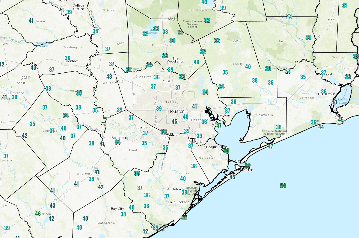
Temperatures this morning are generally in the 30s across much of the area, with a few 40s peppered in. (NWS)

As the day progresses, it will be pleasant, with high temperatures likely to get up close to 60 degrees or so. We won’t be quite as cold tonight, as low temperatures dip down into the low- to mid-40s.

On Saturday, a vigorous little disturbance will trek down the Rio Grande Valley. That puts it far enough away from Houston to keep our rain chances pretty low. On Thursday it looked like we only had maybe a 20 percent chance of a shower as this passed by. Today, I might up that to 40 percent that someone (not everyone) sees a few showers late Saturday afternoon or during Saturday evening. Otherwise, we will see a little additional cloud cover, but it should still be partly to mostly sunny most of the day. High temperatures Saturday should sneak above 60° in most spots, with a few mid-60s possible as long as cloud cover is limited and showers hold off til late. Rain totals will be zero for most folks, but perhaps up to 0.25″ south and east of Houston where shower chances are a bit higher.

Sunday & Monday

Once that Rio Grande Valley system exits, we’re left with mostly fair weather for Sunday and Monday. We’re expecting partly to mostly sunny skies on both days. Temperatures on Sunday will warm from the lower or middle 40s in the morning up into the mid-60s during the afternoon. Monday should see us go even a bit warmer. We’ll warm from the upper-40s into upper-60s or even better.

See full post

After a wet winter, we should now see mostly dry weather for awhile

It has been a wet winter so far for most of Texas in general, and the Houston area in particular. December finished with about twice as much rain as normal for most of the region, and January is well ahead of normal as well. (The map below shows percent of normal rainfall for Texas over the last 60 days. Most of Houston has had 130 to 200 percent of typical amounts.) The reason I’m pointing this out is that, for the first time in awhile, the next 10 days look fairly dry—with only slight rain chances and slight rain accumulations.

“Percent of normal” rainfall for Texas over the last 60 days. (NOAA)

This morning, temperatures range from the upper 20s for inland areas such as Conroe and Huntsville, to the upper 30s for areas along the coast such as Galveston and Palacios. In the city of Houston itself, temperatures are at, or just above the freezing level. High pressure, calm winds, and clear skies have allowed for ideal cooling overnight. We’ll now slowly warm up before another strong front next week.

Thursday and Friday

Expect mostly sunny to sunny conditions, with highs in the mid- to upper-50s. Lows for Thursday night will probably be about 5 degrees warmer than Wednesday night, and by Friday night most of the region should be in the low 40s.

See full post

Rains ending this morning, but cold will remain for Houston

A strong cold front pushed through Houston shortly after midnight, and now temperatures have fallen into the upper 30s and lower 40s across the metro area. We’ll now return to a period of mostly colder weather for the rest of January, and early February, with additional cold fronts on the horizon.

Wednesday

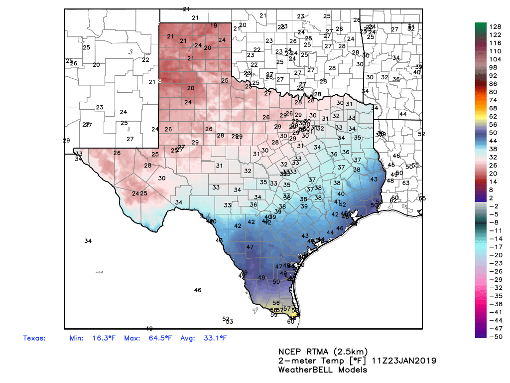
While rain showers have not ended this morning, the activity is beginning to wind down as drier air moves in from the west. Overnight totals for most of Houston measured between 0.5 and 1.0 inch of rainfall, but some areas near Magnolia got 2.0 inches or more. This wasn’t enough to cause any major flooding problems, but it certainly made for a wet night. A wintry mix is now falling in a few areas near College Station and Brenham, but it is unlikely to get cold enough in Houston for sleet or snow before the precipitation ends this morning. That should occur between about 9am and noon, as the last rains move east.

A strong cold front has brought winter-like temperatures to Texas on Wednesday morning. (Weather Bell)

Even with clearing skies, however, temperatures today will struggle to reach into the upper 40s, and with a northerly wind gusting up to 20mph this will certainly be a chilly day across the region. Under clear skies, lows tonight will likely stay at or just above freezing for most of the Houston metro area.

See full post

Rain showers Tuesday night before sunshine the rest of the week

Temperatures have only fallen down to around 60 degrees for most of Houston this morning, and we’ll have one more warmer day today before cooler weather returns with a front tonight, and lasts for the rest of this week.

Tuesday

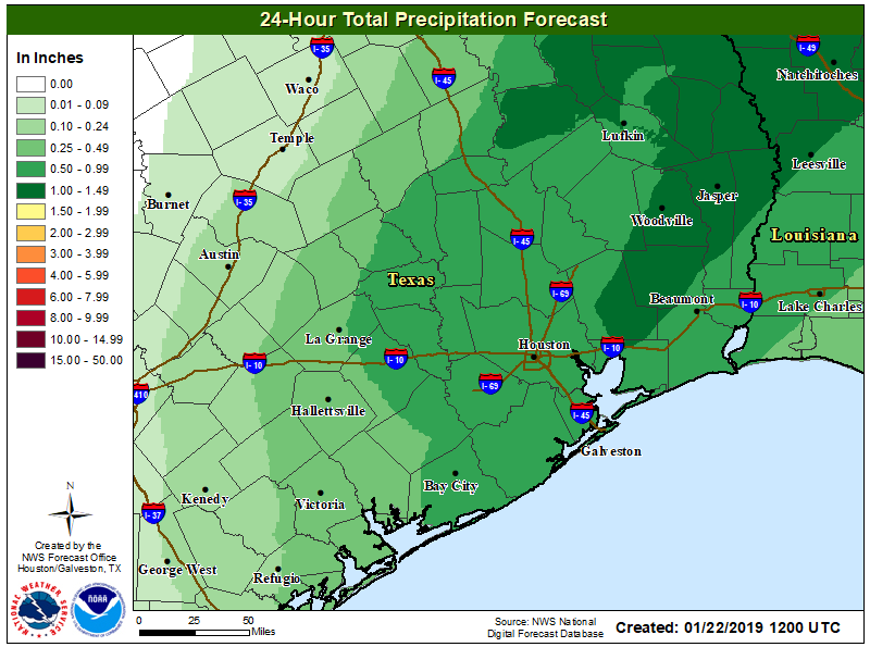
Highs today should generally get up to around 70 degrees, with mostly cloudy skies keeping them from getting much higher. Winds will be blowing out of the south today, increasing moisture levels ahead of a cold front tonight. Although scattered showers will be possible during the daytime, by far the best chance of rain will come tonight with a line of precipitation along the front. The front should reach areas northwest of Houston between 9pm and midnight, roll through Houston sometime between 11am and 2am, and should be off the coast by or before sunrise Wednesday. At this time, accumulations of 0.5 to 1.0 inch of rainfall are likely.

Most of Houston is likely to see 0.5 to 1.0 inch of rain Tuesday night and early Wednesday. (National Weather Service)

It should be noted that some models have been hinting at the possibility of snow or sleet for areas northwest of Houston, such as the Brazos Valley, with this system. However it seems most probable that the colder air needed for wintry precipitation will lag far enough behind the precipitation to preclude this. Can’t rule it out, but it seems doubtful. The chance of seeing anything like this in Houston itself is pretty near zero.

See full post