No tan for you: Houston to enjoy more clouds for awhile

As the forecast for the next several days becomes more clear, unfortunately it means that our skies will be quite unclear. Which is to say cloudy. Very cloudy. Just looking at the “total cloud cover” forecast from the GFS model this morning, skies are forecast to be 98 percent cloudy (or greater) from now through Wednesday morning—with the exception of a brief period Saturday night. So that’s six days of gray skies, and I’m afraid not much help for it.

Friday

It’s quite warm across the Houston region this morning, as temperatures for some parts of the city have yet to fall below 70 degrees. Cloud should limit high temperatures to the mid- to upper-70s today, but it will sure feel humid outside. Some scattered showers, mostly of the light variety, will be possible throughout the day. Accumulations should not be much above a tenth of an inch, if that. Lows tonight will again be very warm for this time of year.

Rodeo weather

Temperatures will be warm, in the low 70s, walking into the show this evening. Relative humidity will be above 80 percent, and we can’t rule out a misty rain before the show, but more likely than not it will just be gray. After the concert, temperatures won’t have dropped much, perhaps down to around 70, and while rain chances will be lower (about 20 percent) they won’t be zero. Again, any rain that falls should be light.

Saturday

A cold front will be sweeping into Texas this weekend, but the bulk of the drier and cooler air will be shunted north of Houston. So, too, should most of the inclement weather.
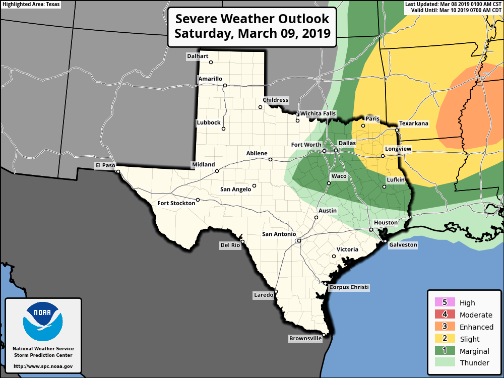
The best chances for severe weather on Saturday will be well to the northeast of Houston. (NOAA)

Therefore while some light rain will be possible Saturday morning, and maybe a thunderstorm or too, for the most part we don’t expect much action in the city and nearby suburbs. The day itself should be warm, in the upper 70s. It’s possible parts of Houston will see some clearing skies during the afternoon and evening, but don’t blink or you’ll miss the blue sky. Rain chances fall to near zero Saturday night.

See full post

Checking our rain chances, looking ahead to Spring Break

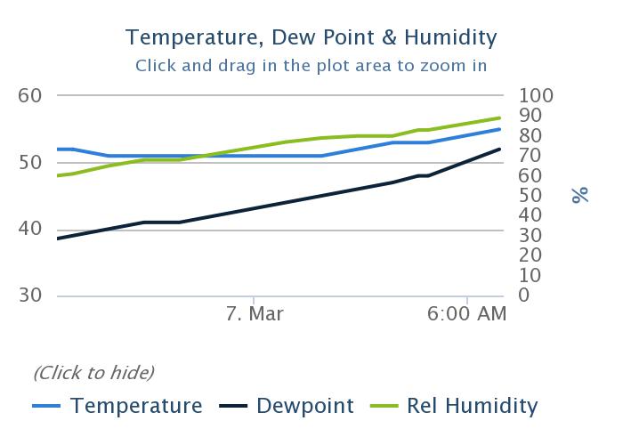
Instead of our normal diurnal pattern, temperatures have risen across the area since midnight for Houston, generally from the lower 50s to the upper 50s. This is indicative of the much warmer airmass that has begun moving into the area, and which may lead to some potentially unsettled weather over the next few days, especially on Saturday. Unfortunately, the weekend weather doesn’t look exactly ace, although Sunday has some potential.

Temperatures, dewpoint, and relative humidity have been on the rise since midnight at Bush IAH. (MeteoStar)

Thursday

Today will be a gray affair, with intermittent drizzle, especially closer to the coast. Some light rain showers will be possible, but for the most part any rain today will be misty. Dewpoints will continue to rise today, leading to much higher humidity, as temperatures rise up to around 70 degrees today.  Low temperatures tonight will not fall much, probably only into the mid-60s.

Rodeo weather

Temperatures will be in the upper 60s at the Houston Livestock Show and Rodeo this evening, with cloudy skies, and light winds. There’s about a 40 percent chance of a light, misty rain, which likely will end before the show ends. Temperatures after the concert will be about the same, as will the 100 percent cloud cover.

Friday

Friday should be similar to Thursday, although 5-7 degrees warmer, and with a healthy chance of morning fog as warmer air moves over cooler waters. Highs will be in the upper 70s, with more light rain showers. Again, accumulations should, at most, be measured in a tenth or two of an inch of rainfall.

See full post

Cold this morning, but rising temperatures are on the way

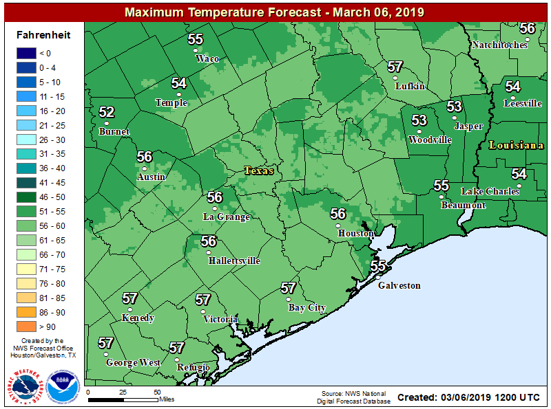
Temperatures have fallen to near freezing across most of Houston, but stayed just above it for the most part except for the usual cold spots such as Conroe and Huntsville. Now, our late winter roller coaster will turn back upward, with a warming trend through Saturday. After today, we’ll also say goodbye to the sunshine until Sunday, at least.

Highs will rebound into the 50s today, and it’s only up from there. (National Weather Service)

Wednesday

Winds remain out of the north, or northeast this morning, but they’re going to gradually swing to the east, and the southeast later today which will presage a warm-up in our weather after Monday’s descent into the depths of winter. Highs today should climb into the 50s under partly to mostly sunny skies, and with relatively light winds it will feel a fair deal warmer than Tuesday. Clouds return this evening, and there’s a slight chance of drizzle as early as the pre-midnight hours tonight. Lows likely will fall only to around 50 degrees.

Rodeo weather

This should be one of the nicest evenings for the rodeo so far, if a bit chilly. Temperatures going into the show should be in the low 50s, with mixed skies. Coming out afterward, temperatures won’t have budged much, but skies will probably be mostly cloudy by that time. We can’t rule out some light, misty rain after the show, but chances are less than 20 percent.

Thursday and Friday

Wednesday’s wind shift will drive big temperature differences toward the end of the work week. These will be mostly gray days, with temperatures in the 70s, and dewpoints nearly as high so we can expect to feel the humidity. Overnight lows will only fall into the 60s. Some light rain is possible both days—30 to 40 percent—but accumulations should be slight as the heavier rain probably will hold off until Saturday.

See full post

Putting this morning’s freeze into perspective

It is quite cold for early March across Houston, but this is far from uncharted territory. Here are just a few data points this morning:

  • As of 6:15am, the low at Bush Intercontinental Airport is 30 degrees. The record low for today is 25 degrees, set in 1989.
  • The latest freeze ever recorded at Bush IAH came on April 10, 1973, when the low was 31 degrees.
  • College Station did shatter a record on Monday, with a maximum temperature of just 35 degrees—five degrees below its previous record of 40 degrees.

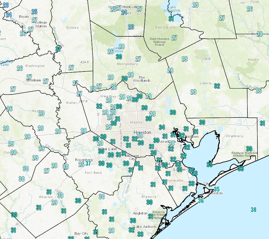
In short, it’s very cold across Houston with a freeze blanketing almost the entire region except for the coast, but it is not unprecedented to have such an outbreak of cold weather in March.

Temperatures at 6:30am Tuesday. (National Weather Service)

Tuesday

After an long string of mostly cloudy days, we’re going to see the return of mostly sunny skies today. This should allow temperatures to rise above freezing fairly soon this morning, but with northerly winds continuing to bring cooler weather into the region we can expect temperatures today to only get up into the mid- to upper-40s. Tonight should be cold again for the region, with overnight lows perhaps 2 to 3 degrees warmer than Monday night.

Rodeo weather

Conditions at the rodeo this evening will be cool going in, with highs holding on to the mid-40s just before the sun goes down. Winds will be fairly light, at 6 to 8mph out of the north, so that will help keep things from being too cold. By the time the show ends, however, temperatures will have fallen into the upper 30s, so be prepared for that.

Wednesday

The high pressure associated with this strong cold front will move away on Wednesday, and as that happens winds will turn easterly and eventually southerly. This will mean two things for Wednesday: the return of some clouds, and a warmer day in the 50s. Lows Wednesday night will probably only fall to around 50 for most of the region as a warmer pattern begins settling in.

See full post