Cloudy, rainy period ahead with a possible reprieve on Sunday

As Houston continues to slide toward summer, we’re looking at a period of partly or mostly cloudy skies, on-and-off rainy, humid, and fairly warm weather during the next week or so. Nights will remain warm and muggy for the foreseeable future, with much of the region never falling below the 70s throughout the forecast period.

Tuesday

We may see a few brief, very scattered, light rain showers today—but for the most part skies will simply be cloudy. Despite the lack of sunshine, highs will generally get into the mid- to upper-80s on Tuesday, with temperatures a bit cooler near the coast due to the moderating influence of the Gulf waters. Southerly winds will be noticeable, gusting to perhaps 25 mph. Lows tonight will be in the 70s for all but very far inland areas.
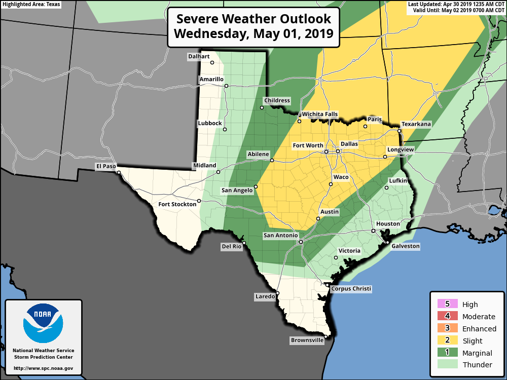
Severe weather outlook for Wednesday. (NOAA)

Wednesday and Thursday

These should be a pair of partly to mostly cloudy days. A cold front is going to be moving through north Texas, but it’s going to stall before reaching the Houston area, and therefore any severe weather should remain to the northwest of the region (see the map from NOAA’s Storm Prediction Center above). As a result, Houston and its surrounding counties will see only a 30 or 40 percent chance of rain each day, with perhaps a few tenths of an inch of rain in terms of accumulation. Highs will remain in the mid- to upper-80s.

See full post

R.I.P. Spring, 2019

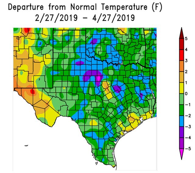
It is difficult to quantify a “nice” Spring, but it sure seems as though the last couple of months have been quite pleasant in Houston, Texas. We’ve had a few storms, which is normal for spring, but mostly we’ve seen partly to mostly sunny weather, fairly dry air, and cool but not cold nights.

But now, the party’s over. I’m sorry to report that Spring, 2019, died this weekend. As recently as Sunday morning, lows were in the low- to mid-60s for much of the region, but starting this today we’re going to see a string of mornings in the 70s, with May and then June right around the corner. Spring was 75 days old.

Average temperatures during the last 60 days have been near or below normal for most of Texas. (NOAA)

Monday

After a lovely, sunny weekend, we’ll see the return of partly to mostly cloudy skies today, although there still should be enough sunshine to allow high temperatures to push up into the mid-80s. The bigger story will be the return of onshore winds, which may gust up to about 20 mph this afternoon from the south. With muggier air and mostly cloudy skies tonight, low temperatures on Tuesday morning will only fall into the low- to mid-70s for the region.

See full post

Read this post, then go out and enjoy the next few days!

I remember a time back in February or January, where we had a string of like seven or eight weekends in a row with rain chances and clouds. We have gone ahead and mostly made up for those lately. And this weekend will add to that recent legacy.

Today

Today will probably be one of the last nicest days until autumn, unless we can sneak another decent front in here in early May. Expect wall to wall sunshine. We’ll warm up from the 60s this morning into the mid-80s this afternoon. Humidity will remain on the low side. Air quality may be poorer than usual today, and today has been declared an Ozone Action Day, so keep that in mind if you’ll be heading out to enjoy the weather.

Saturday

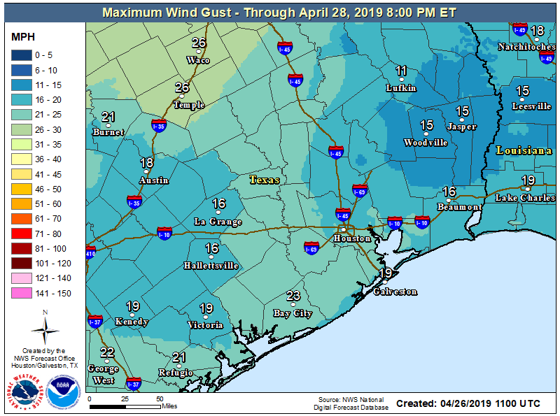
It looks as though Saturday will be almost a carbon copy of Friday. It will be just a touch more humid, though probably not enough to really notice. Expect temperatures to warm from the low-to mid-60s Saturday morning into the mid-80s once more. If you’re riding in the BP MS 150, expect a fairly steady 5 to 10mph tail or occasional cross wind.

Maximum wind gusts through Sunday should be under 20 mph in most places and mostly at your back if you’re riding in the BP MS 150. (NOAA)

We could see a few gusts up to 15 or 20mph on some of the more exposed ridges along the route. Look for similar conditions Sunday.

See full post

Houston to enjoy a couple of wonderful spring days now

As expected, Wednesday night’s storms were mostly a non-event for Houston, with most of the region outside of the Brazos Valley picking up 1.0 inch or less of rainfall. We’re now going to enjoy a few somewhat cooler nights before the onshore flow returns. After this, however, it appears the region will settle into a warmer and definitely more humid pattern for awhile—a good reminder that summer is nigh.

Thursday

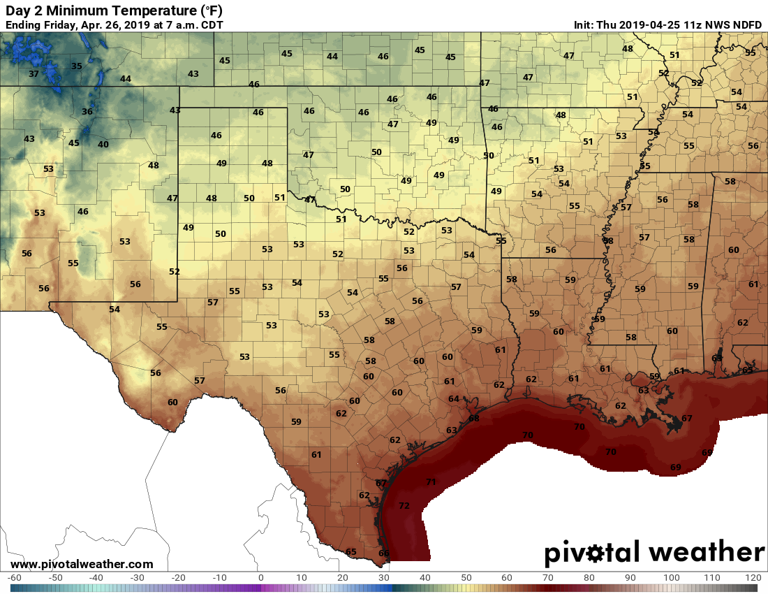
Skies will be clearing out today, and this will allow highs to probably get to about 80 degrees despite a modest northwesterly wind. Temperatures will fall off this evening as the sun goes down, and with clear skies, areas well inland may see the upper 50s, while most of Houston stays in the low 60s.

Low temperatures look fine for Friday morning. (Pivotal Weather)

Friday

A banner day, with lots of dry air, sunshine, and light winds. High temperatures will get into the mid-80s. We’re going to have one more cool night, as lows get down into the low 60s in Houston again. This really will be the last hurrah for dry air, for awhile, so enjoy it.

See full post