Summer-like weather for one more week, but then probably a front

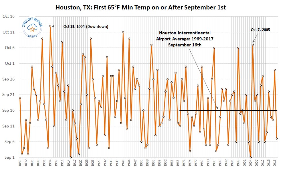
Good morning. Houston’s summer-lite weather will continue for most of this week, with warm days and nights. Rain chances will be low for most of the week, given the presence of high pressure. We’re still waiting for that first cool front. As you can see from our cold front graphic below, anything after October 7th would set a record for the latest first fall front since the official monitoring station was moved to Houston’s Intercontinental Airport in 1969. A front appears to be in the cards “soon,” perhaps even by that date. More on that below.

When is the first day of “fall” in Houston. (Brian Brettschneider for Space City Weather)

Monday

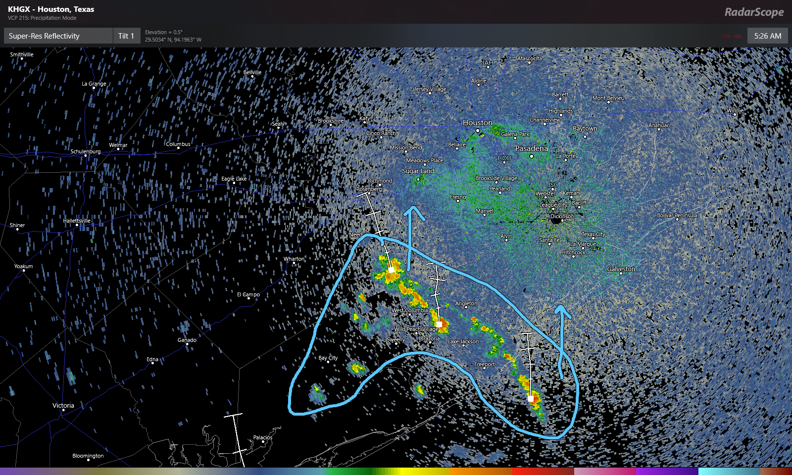
Atmospheric moisture levels are fairly high over the Coastal Bend area of Texas this morning, so areas near and around Matagorda Bay could see some rain storms today. But most of the Houston metro area, including Harris and surrounding counties, should remain dry today. Expect partly sunny skies, with high temperatures in the low 90s.

Tuesday and Wednesday

More of the same, as high pressure over the southern United States expands eastward a little bit. We can’t entirely rule out some streamer showers, but again these should be mostly dry (which is not to say not humid) days. Highs around 90 degrees for most, with warmer temperatures possible for well inland areas.

See full post

Unrelenting late summer weather for Houston will carry forward into October

This week has not been oppressively hot and humid, but it still has been rather toasty for the end of September. That’s not going to change anytime soon unfortunately.

Today

The amount of moisture available in the atmosphere today will be a good bit more than what was available yesterday, which means we should see at least a smattering of some showers and storms pop up through the day. Radar already shows some showers this morning south of Houston toward Lake Jackson and Angleton.

A few showers across Brazoria, Matagorda, and Wharton Counties will lift north, as new showers develop today. (RadarScope)

Based on this and weather modeling, the highest rain chances today should be south and west of Houston, though everyone has at least a chance of a shower. Outside of that, it will be partly sunny and continued hot. Look for high temperatures near 90 degrees.

Weekend

Moisture levels will slowly drop this weekend, but with onshore flow continuing, we have to at least mention a passing shower or storm Saturday and Sunday afternoons. If you’ve got outdoor plans this weekend, you should be able to go forward with them without much issue. You may encounter a brief downpour but probably nothing worse. Daytime highs will likely be up around 90 again. Nighttime lows, which have actually not been too bad (in the low-70s) this week will likely creep back into at least the mid-70s inland and warmer at the coast.

See full post

Late-summer weather to continue for awhile in Houston

Houston will remain in a late-summer pattern for the next week to 10 days—it seems like we’ve been saying that forever—but we can only write about the weather we’re given.

Thursday

We’re going to have one more warm and sunny day today, similar to Tuesday and Wednesday. Highs will be around 90 degrees, although areas well inland may be a bit warmer than that. This should provide the region one more good day to really dry out.

Friday

Rain chances will pick up a bit on Friday, as a weak tropical disturbance moves toward Mexico and brings increased moisture levels into the Texas coast. Any showers should be relatively brief, and the day should otherwise have partly sunny skies with high temperatures around 90 degrees.

The best chances for rain showers will come this weekend, near Coastal Bend. (Pivotal Weather)

Saturday and Sunday

As moisture levels peak on Saturday, we are likely to see rain chances push up to around 60 percent for the coast, and 40 percent for inland areas. Again, showers should be fairly transient, although they could certainly bring some intermittent downpours to the area. Most of the region should see 0.25 to 0.5 inch of rain, although the coast could see up to 1 inch. Rain chances begin to slacken on Sunday, but do not go away entirely. Expect highs of around 90 degrees.

Next week

High pressure returns by Monday or so, which should shut down rain chances for the most part, at least into the middle of next week. It will remain warm. After that time? Who knows. The weekend of October 5th may see another surge of Gulf moisture, or, if we get lucky, the arrival of the region’s first cool front. It’s hard to have confidence in either forecast.

Tropics

We really have no significant concerns with regard to the Gulf of Mexico right now.

Sunny, with a chance of showers and thunderstorms this weekend

Houston enjoyed a sunny day on Tuesday, and we’ve got a couple of more to go before some rain chances return this weekend. But don’t worry, we’re not expecting anything too extreme.

Wednesday

With high pressure in place, we anticipate another partly to mostly sunny day today, with highs touching 90 degrees for many parts of the region. Some areas west and northwest of Houston may even reach highs in the mid-90s, which is pretty extreme for late September, even in Texas. Normal highs for late September are the upper 80s. Rain chances are near zero.

Thursday

This should be a day similar to Wednesday, with hot conditions and rain chances likely 10 percent or less. Summer marches onward, it seems.

NOAA rain accumulation forecast for now through Sunday. (Pivotal Weather)

Friday, Saturday, and Sunday

The pattern changes, subtly at least, this weekend. High pressure will retreat eastward, opening up Texas to more of a southerly flow of moisture. This will increase rain chances, and introduce the possibility of thunderstorms. But for the most part, we expect these storms to pop up, die out, and move on. Overall accumulations for almost everyone should be one-half inch or rain, or less, although a few storms may become fairly intense for a time. Rain chances on any individual day should be less than 50 percent. And skies, for the most part, should be sunny. Highs will be around 90 degrees.

See full post