Finally, a few rain-free days for Houston

Good morning. Another round of surprisingly nasty showers popped up on Monday—I know because about 2.5 inches fell in short order right on top of my home—but we should be done with that for awhile. We should remain in a more or less late summer pattern for the next 10 days or so, after which time we can probably reasonably expect a cold front to be near at hand. We also discuss the tropics today, which you really should not be worrying about.

Tuesday

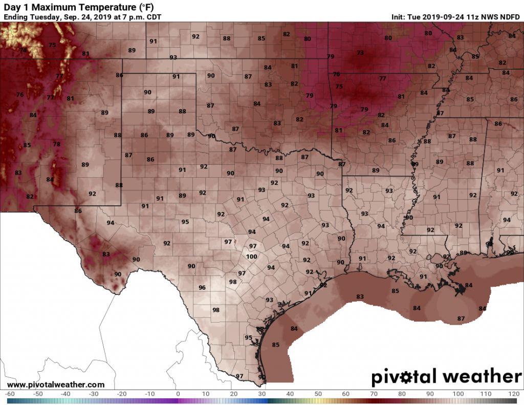
Today should be hot and sunny. With high pressure building from the east and a drying atmosphere, rain chances should fall back to near zero. Highs will be around 90 degrees, with lows tonight in the low 70s. It’s not fall, certainly, but at least it’s not the dead of summer.

Texas “enjoys” the second day of fall. (Pivotal Weather)

Wednesday and Thursday

These days should bring more of the same, with only very slight rain chances and mostly sunny skies. Again, expect high temperatures of around 90 degrees with good drying-out weather for the region.

Friday, Saturday, and Sunday

The high pressure ridge that will bring hot and sunny weather this week will back off some heading into the weekend, opening up the region to somewhat more moisture from the Gulf of Mexico. By no means are we looking at a washout—however each day will likely carry 30 to 40 percent chances for showers and thunderstorms. Overall accumulations will likely run under one-half inch for most, and the days will likely be partly to mostly sunny. Highs, of course, will remain around 90 degrees.

See full post

Fall begins—where the heck is Houston’s first cool front?

Today marks the autumnal equinox, which means it is the first day of fall. But Houston has felt anything like fall so far this September, as low temperatures have rarely fallen below 75 degrees. The city has yet to see its first real fall cool front—which for the purposes of Houston we define as a daily minimum of 65 degrees or cooler. As you can see on the chart below, the first fall front typically comes around September 16th, or one week ago. The bad news is that there is no front on Houston’s horizon for the next week or so, but the good news that I don’t think we’ll quite break 2005’s record, and have to wait all the way until October 7th. More below.

When is the first day of “fall” in Houston. (Brian Brettschneider for Space City Weather)

Monday

On Sunday, some nasty but very localized storms developed in northwest Houston along Cypress Creek near the Willowbrook area. We’re going to see the potential for similar storms today, although there should be a bit more south-to-north motion as moisture streams in from the Gulf of Mexico. Overall rain chances are about 50 percent, and while accumulations for most will be under one-half inch, we can’t rule out some isolated thunderstorms bringing a quick 1 to 2 inches of rain. High temperatures should be near 90 degrees.

Tuesday, Wednesday, and Thursday

As high pressure extends its reach over the Houston area, we should see rain chances drop back to around 10 to 20 percent for each of the mid-week days. Accordingly, we should see high temperatures around 90 degrees, with overnight lows in the low- to mid-70s. Mostly sunny skies should really help the area dry out after Tropical Storm Imelda’s nastiness.

See full post

Moving on from Imelda

Imelda is thankfully in our rear-view mirror now, and we can begin the process of cleaning up from the latest in a slew of problematic flooding events in Southeast Texas in recent years. Eric and I will take some time to process this and recap it for you in some capacity next week. The weather doesn’t stop, so let’s discuss our weekend.

First, let’s talk about residual Imelda-related issues. Most bayous across central, southern, and western Harris County are back in their banks this morning. We do still have flooding issues in eastern Harris County.

  • Greens Bayou is still out of banks downstream of Highway 59 to the Ship Channel. It has crested and should be back in its banks soon at Mount Houston. Greens will continue slowly falling downstream today.
  • Garners Bayou is out of its banks at the Beltway, but is falling.
  • Cedar Bayou has crested at Highway 90 and is falling. It should crest soon at FM 1942.
  • Both the East and West Forks of the San Jacinto River have crested in major flood. They should both be back in moderate flood later today.
The San Jacinto River below Lake Houston will rise and crest in major flood today before slowly dropping back this weekend. (NOAA/NWS)

The San Jacinto River near Sheldon (above) continues to rise and should crest this afternoon before slowly falling this weekend.

Folks living along the Brazos River, you have nothing to worry about, as rains both over you and upriver were not too significant this week.

Those trying to travel to or from Beaumont, note that I-10 is shutdown at the San Jacinto River due to multiple barge strikes. And it sounds like it might be awhile.

I-10 also remains closed in both directions between Winnie and Beaumont due to high water.

Today

Not everyone will see showers or storms today, but they will be around. Any storms today will probably move south to north at a slow, steady clip, so they could put down a quick inch or so of rain. While this won’t lead to widespread problems, there could be a handful of locations today that see some short-fused street flooding or some rises on bayous. Again, we don’t expect anything significant. With a good deal of clouds still, we should see highs in the mid- to upper-80s.

Weekend

Both Saturday and Sunday should see a mix of sun and clouds with just a chance of a shower or storm in a few spots. We’re sort of back to typical late summer this weekend. Look for highs near 90 degrees or in the low-90s and lows in the mid- to upper-70s.

See full post

Houston should see a mostly quiet night, storm-wise

As anticipated, the greater Houston area radar has quieted down considerably with the loss of daytime heating. And thank goodness for that.

During the overnight hours we can’t rule out development of additional showers and thunderstorms, but we’d expect these to be fairly scattered and are not particularly concerned about additional, prolonged heavy rain. We just do not anticipate anything too organized getting going—although Lord knows Imelda has surprised us. Rain chances are probably a little higher to the east of Interstate 45 tonight, but again we don’t expect accumulations to be more than about a quarter of an inch where rain does fall.

A mostly quiet radar at 9pm CT Thursday is a beautiful thing. (kktv.com)

We are well beyond the worst of Imelda, but we’re likely to see a decent chance of scattered storms on Friday, with chances diminishing further into the weekend. We should see mostly sunny days with highs in the upper 80s on Saturday and Sunday, which sounds pretty darn nice after all we’ve been through. Matt will have a comprehensive update in the morning.