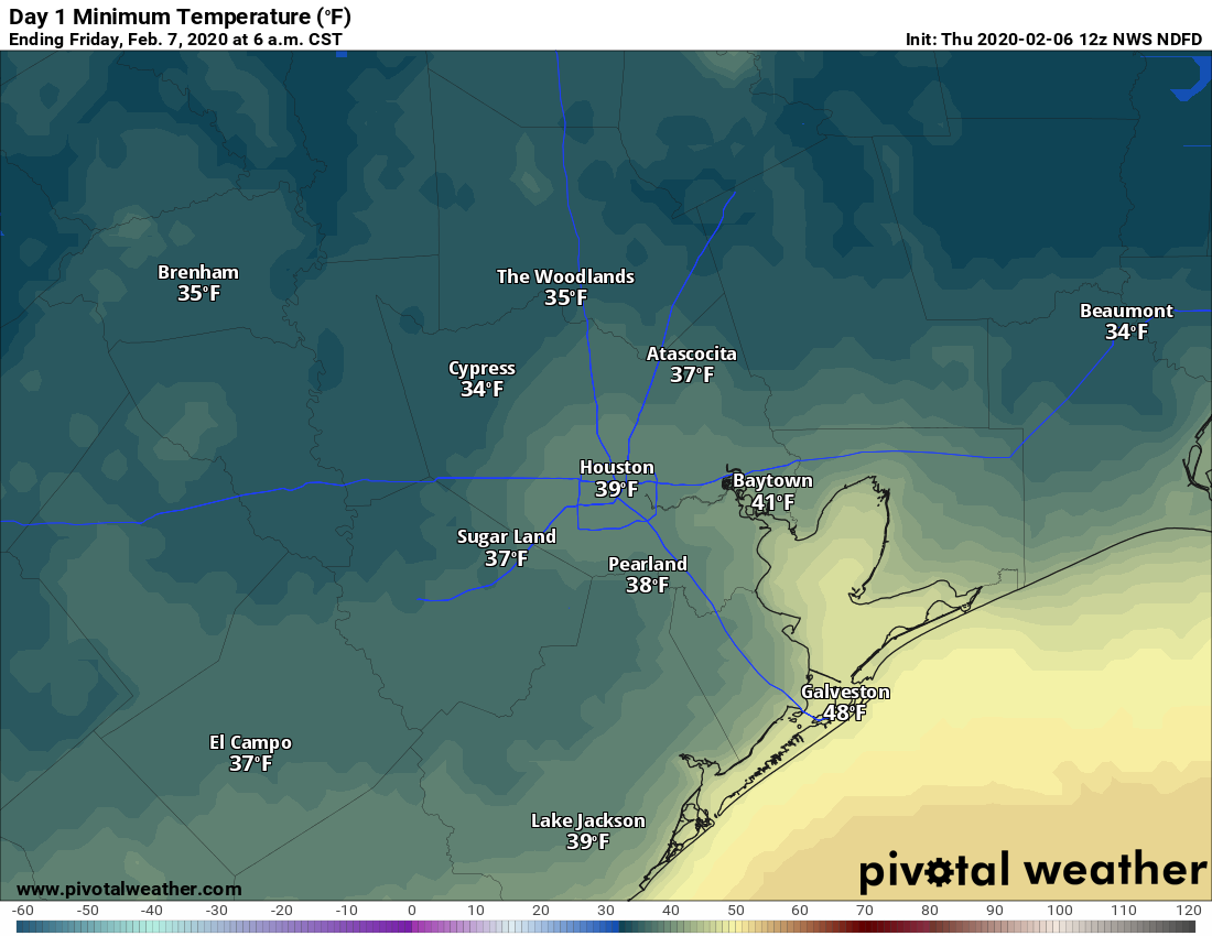
Temperatures have fallen into the mid- to upper-30s across most of the metro area this morning, with only areas immediately along the coast holding on to 40-degree readings. Clear skies tonight will allow for another chilly night before Houston warms up for the weekend. Most of next week looks unseasonably warm, likely with a string of nights in the 60s, and much of the rest of February will probably see above normal temperatures. Probably, this recent strong front represents the last gasp of truly cold air this season.
Thursday
Overcast skies this morning will begin to clear by or before noon, but a persistent northwest wind will continue to bring cold air into the region. This should limit high temperatures to about 50 degrees for most, with wind gusts above 20 mph making conditions feel cooler. Winds should die down somewhat overnight, and along with clear skies, this will help inland areas get down into the mid- to upper 30s again.
Onshore winds return Friday, but skies will be sunny all the same. Expect highs in the upper 60s to around 70 degrees with rather pleasant conditions. With the influence of southerly winds, lows on Friday night will likely only drop into the 50s for most of the area under mostly clear skies.
Winter returns to Houston today as a cold front has pushed through most of the region already this morning. We’ll see much colder temperatures for sure. In addition, we might have some wintry weather overnight while most of us are sleeping. It will not amount to anything that would impact travel overnight or during Thursday morning’s commute, but nevertheless we will discuss it in today’s post.
Today
The cold front is now through about 80 to 90 percent of the region. Temperatures have fallen into the 40s out near Katy and Rosenberg and up toward Lake Conroe. We’re in the mid 50s in Houston proper.
Observations as of 5:30 AM show that the cold front is already just about through the entire region. (NOAA)
Coastal areas that are still in the 60s or even near 70 will see the front arrive over the next couple hours. The Port Arthur area may have to wait until late morning or Noon for the front to swing through.
Temperatures will settle into the 40s and 50s. Because of the early frontal passage, we may see temperatures level out or warm back to the mid 50s this afternoon before resuming their fall tonight. Look for a northwesterly breeze as well to keep it feeling a bit colder.
It has been mostly dry so far. Scattered showers should develop this morning, especially from Houston east and south. I think the quicker timing of the front is out of sync with what we need in the upper atmosphere to get showers and storms going, and that’s why this system is going to disappoint in the rain department overall.Otherwise it will be overcast to mostly cloudy today.
Tonight
The back edge of this system is going to swing through the area overnight. As it does so, it may have just enough moisture to work with to squeeze out some precipitation. And with temperatures falling into the 30s across the area, it may be just cold enough to allow for rain showers to mix with ice pellets (sleet) or snow. Again, impacts are unlikely from this, but since it would be such a novelty to see snow in Houston, it’s worth discussing more in depth.
As I wrote yesterday, the exact details of winter weather scenarios in the Southern Plains are inherently difficult to nail down (a topic for another post). For this event, we have high confidence in timing (roughly midnight through 6 AM) and a lack of direct travel impacts. We have somewhat lower confidence in what exactly will fall from the sky.
Different weather models have relatively different solutions for tonight. Most keep the wintry mix out of Houston, but they disagree on how things will look. (Texas Tech, Weather Bell, Pivotal Weather)
The maps above show three different higher resolution weather models and what they predict radar will look like at Midnight tonight. The Texas Tech WRF (top left) and HRRR (bottom) both are rather uninspired, meaning any precip would be light and even the risk of mixing well north of Houston would be pretty low. The NAM model (top right) is a bit more aggressive, which could yield a mix of rain and sleet or snow north of Houston, possibly even into some of our northwest suburbs when the precipitation falls at a heavier rate. Both subsets of models here seem realistically possible, given the condition of the atmosphere tonight. If there’s not enough moisture, you get the first scenario, but if we can overcome that sufficiently, you get the second scenario. It will be interesting to watch the progress of these models through the day today to see which outcome seems more likely.
Either way, accumulation is not expected from this and neither are any tangible impacts. If this changes for some reason today, we’ll update you. Regardless, who am I kidding? I’ll probably be up at 2 AM looking out the window.
Overnight lows will fall into the low or mid 30s north and west of Houston, while it should be in the upper 30s in the city and elsewhere away from the coast.
Overnight lows will be above freezing but in the 30s away from the coast. (Pivotal Weather)
Quick reminder: A good old fashioned winter storm is underway in West Texas with winter storm warnings from Marfa through Midland into Wichita Falls and up to Oklahoma City today. Visit the National Weather Service for the latest forecast information, and visit DriveTexas.org if you are planning to travel northwest of the Houston region today or tonight.
Changes are coming to the Houston region beginning late tonight and tomorrow morning, taking us back into a wintry pattern for a couple days. Let’s break it all down.
Today
It actually should not be a terrible day today overall. It will continue quite warm and humid, but rain chances look low for most. The best chance of showers today would be for areas east and north of Houston, with a slightly better chance late today versus earlier. So have the umbrella, but I would be fairly surprised if you actually needed to break it open.
High temperatures today will flirt with 80 degrees in many spots. (Pivotal Weather)
Today will be quite warm. We should be able to reach the upper 70s with little trouble today, and I think several 80 degree readings will be reported, particularly if we can break the clouds a bit. Some patchy fog is possible in Galveston or near the bays as the day goes on. It will probably be breezy again today, but winds should not be quite as strong as Monday.
Tonight & Wednesday
The chance of showers and even a few heavier thunderstorms will pick up overnight tonight and into Wednesday morning as our cold front approaches. We are not expecting any severe weather at this time.
In terms of timing, I think the front will approach the northwest suburbs between 10 PM and 1 AM tonight. From there, it gets a little trickier to exactly time out, but in general, a southeastward push of colder air should work across the region from the north through the morning.
Temperatures early tomorrow will be all over the place. Behind the front, essentially from Houston north and west, tomorrow morning should already be in the upper 40s through mid 50s. South and east of Houston may be in the low to mid 60s. The front will probably stall over Houston in the early morning, then resume a slow south and east slog by to mid late morning, reaching the coast by Noon. If you’re still on the warm side of the front tomorrow, look for a slow, steady 10-15 degree drop in temperatures after it passes. We should all drop back into the 40s (low 40s N & W, upper 40s near the coast) Wednesday afternoon. These shallow, cold air masses tend to overperform more often than they underperform around here, so I’m taking a slightly more aggressive posture with things today
In addition, it will be breezy behind the front, adding an extra chill.
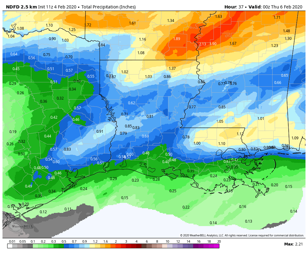
Total rainfall through Wednesday evening will be fairly minor overall. Many locations will see a half-inch or less overall. Some pockets north of Houston could see close to an inch though. (NOAA via Weather Bell)
Rain totals will range from a half-inch or less south of Houston to perhaps near an inch in a few spots north. Showers should taper off in the afternoon on Wednesday.
After our splendid weekend weather—and who can quibble with two mostly sunny days, dry air, light winds and moderate temperatures?—our weather during the first half of the week will turn warmer, humid, and a little more unsettled before a strong cold front sweeps through the area. The first half of next weekend looks wonderful again.
Monday
Southerly winds are really going to get cranked up this morning, eventually gusting into the 20s, or possibly even the 30s for the western half of the metro area. These winds will help bring in warmer, more humid air, allowing high temperatures to rise into the mid-70s during the afternoon hours. It might be warmer, but for mostly cloudy skies keeping a lid on daytime heating. Those same clouds will insulate the area during the overnight hours, keeping low temperatures in the mid-60s. Light rain will be possible Monday and Monday night, but most of the area should remain dry.
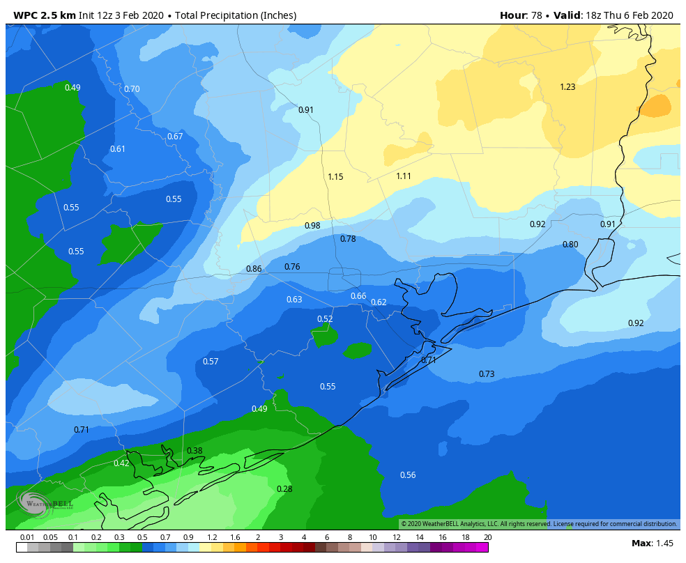
NOAA rainfall prediction forecast through Thursday morning. (Weather Bell)
Tuesday
Another day a lot like Monday, albeit with slightly lower winds. We’ll still see plenty of cloud cover, and if anything temperatures on Tuesday should be a few degrees warmer, possibly reaching 80 degrees. Rain chances will again be in the neighborhood of 30 percent for the region, with mostly light showers where precipitation does occur. Lows Tuesday night will again be warm—at least ahead of the cold front.