Looking like heavy rain chances will peak on Saturday

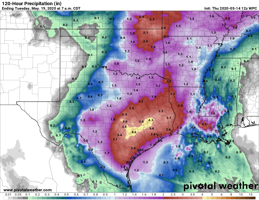
Houston will remain in a fairly wet pattern through the weekend, with the greatest likelihood of rain on Saturday. While we are watching for the potential of widespread, heavy rainfall, right now we think rain totals will be manageable for most over the next four days with amounts probably in the range of 1 to 3 inches. What we’re concerned about is more localized rainfall amounts, which could reach 5 inches or higher.

Thursday

It’s quite the muggy morning for mid-May, with overnight low temperatures not having fallen below 75 degrees for much of the area. We’re seeing some showers develop offshore and these should migrate inland during the daytime—most areas probably have about a 40 percent chance of rain. These should remain fairly scattered and fade out by this evening. Otherwise, skies should see a mix of clouds and sunshine, with highs pushing into the mid- or upper-80s depending on how much sun breaks through this afternoon. Winds will be light, out of the south. Low temperatures Thursday night will again be quite warm.

NOAA rain accumulation forecast for now through Monday. (Pivotal Weather)

Friday

On Friday Houston will remain in this pattern where there’s some lingering high pressure, but not enough to stamp out showers. As a result we’re likely to see weather similar to Thursday, with some thunderstorms breaking through, but nothing too widespread or organized. Highs should again be in the upper 80s.

See full post

Stray showers possible today, with the potential for heavy rain this weekend

Good morning. You may have seen that a subtropical storm is likely to form off the southeastern United States during the next several days. It presents no threat to land, and it’s not all that uncommon for these kinds of tropical systems to form in May. However, the system should serve as a reminder that Atlantic hurricane season is coming, and forecasters generally believe this season has a good chance of being fairly active. Here is some basic advice from FEMA about making a plan for this year’s season.

Will the Atlantic season’s first named storm form here soon? (National Weather Service)

Wednesday

If you checked the radar to the west of Houston on Tuesday evening it looked fearsome at times, but the storms waned considerably as they moved into the Houston area. (Well to the southwest of the city, in Jackson County, as much as 8 inches of rain fell in one location). Accumulations across Houston were generally about one-quarter inch, give or take. Some additional rain is possible today, although we think any showers will be fairly scattered. Skies will see a mix of clouds and sunshine, with highs probably pushing up into the mid-80s. Overnight lows will only drop into the low 70s.

Thursday

Thursday should bring more of the same. Although we’re under a moist, southeasterly flow off the Gulf of Mexico, there’s just no great trigger for showers. So while we’ll see some gray skies, we don’t think any showers that pop up will be too organized, or last for too long.

See full post

AC giveaway from Reliant returns!

Summer is coming—which means months and months of heat and humidity for our fair city. So this is a great time to announce that we’re bringing back an extremely popular promotion from last year. In 2019 Reliant gave away two complete AC systems entirely FREE. And we’re thrilled to announce that they’re doing it again! As a Space City Weather reader, you’re the first to know.

If you do not need to read any more, drop everything and click here to enter.

We’re really pleased to offer this promotion to readers again this year. It speaks to Reliant’s commitment to our vision of keeping the greater Houston area informed about weather in a reliable and sensible way. There is really no catch, and these systems are the whole enchilada. The two air conditioner systems are worth up to $11,000 each. (But really, can you put a price on cool air in August?)

(Reliant)

Here are the details of this year’s contest, which will take place over two phases from now through September:

  • Phase I winner chosen from May 12-July 15 entries
  • Phase II winner chosen from July 16-September 15 entries
  • One winner will be chosen, randomly, at the end of each phase
  • Once you enter, you’re entered for both phases of the contest
  • Winners must be 18, and own a home in the greater Houston metro area
  • Your AC system must be eight years or older

If you’re not eligible for the contest and know someone who could really benefit from a free, new AC system heading into the hottest time of the year, please share the contest link with them.

Complete details and the entry form are available at the contest page. Good luck to everyone and thanks to Reliant for helping us stay cool!

Scattered storms possible today, a wet weekend likely on tap

Good morning. Temperatures this morning have only fallen to around 70 degrees, markedly warmer than recent days. However, the ascent of our daytime temperatures will be slowed this week—we should stay comfortably in the 80s rather than going up to 90 degrees—by decent rain chances and the possibility of storms. A fairly potent upper-level low pressure system could bring heavy rainfall to the region this weekend, but unfortunately we’re lacking details for a more precise forecast.

High temperatures Tuesday should reach the mid-80s. (Pivotal Weather)

Tuesday

A line of storms just west of Interstate 35 this morning should steadily move west toward Houston today. The question is how much moisture they will have to work with as they move into our region. Rain chances this afternoon appear best to the west and northwest of Houston, in areas such as Sealy, College Station, and Brenham. But I think it’s definitely possible that some of these storms hold together as they move into the Houston area later this afternoon or during the evening. Briefly heavy rain and strong wind gusts will be possible. Rain chances for the region will be on the order of 20 to 30 percent. High temperatures should climb into the mid-80s under partly to mostly sunny skies.

Wednesday

Right now Wednesday appears to be similar in nature to Tuesday, although any afternoon storms that fire up will likely be less organized. Expect highs in the mid-80s, with partly to mostly sunny skies.

See full post