Tropical update: After a rapid start, the season has slowed down

The 2020 Atlantic hurricane season got off to an early and fiercely active start back in May and early June, which had many people justifiably on edge wondering what was to come. Now, here we are on June 30th and we’ve had one additional storm since Cristobal made landfall in Louisiana at the beginning of June. Things have thankfully slowed down a bit. We’re going to aim to provide sort of a broad overview of the state of the tropics every Tuesday here at Space City Weather, just to keep you apprised of things we don’t make time or space for in the morning updates.

Tropical outlook in a sentence

While we will be watching the potential for some kind of hybrid system to develop off the Florida or Georgia coast early next week, we do not see any threats to the western Gulf for the foreseeable future.

Active start, sort of

Our most recent named storm was Dolly, which briefly threatened some fish in the north Atlantic back on June 23rd. Dolly just missed being the earliest “D” storm on record by 3 days. For those of you scoring at home, the earliest “E” storm was 2005’s Emily, which formed on July 11th.

We normally don’t get to the letter “D” storm until mid-August. (NOAA)

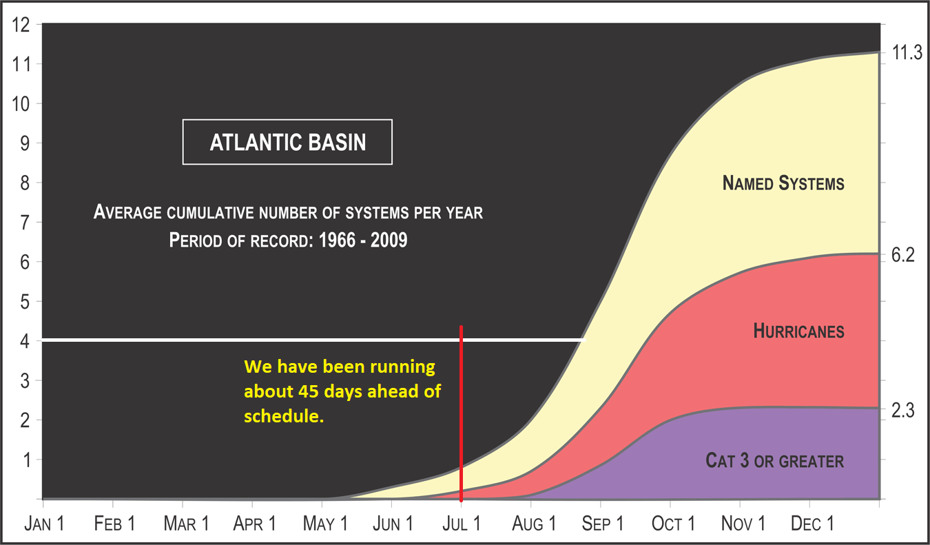
But interestingly, even though we’re running about 45 days ahead of schedule in terms of named storms, when you look at cumulative intensity, it’s less impressive. We like to sometimes look at what we call “accumulated cyclone energy,” or ACE to really hammer home how active a season has been to place it in better historical context. We can name more storms now because we have superior technology to even 10 or 20 years ago that allows the National Hurricane Center to name something borderline that might have slipped through the cracks in the past. Stronger storms likely would not have been missed in the past, so ACE provides a good way to almost compare apples to apples better than number of storms would.

So what is ACE? We said there would be no math, so I won’t go into the details of how it’s calculated. Read the Wikipedia article here for more (yes, it’s legitimate and accurate). Essentially, it’s just an equation that factors the length of time a storm had particular sustained winds. The stronger the winds, the longer it maintains strong intensity, the higher the ACE. Since it only factors in wind, by no means is it perfect. For instance, Hurricanes Harvey, Andrew, and Katrina won’t crack the top 25 list of storms that have generated the most ACE because they didn’t last long enough. So in that respect, the calculation is imperfect, but overall it’s a pretty good gauge of where a season stands historically. You can track seasonal ACE in real time here.

The accumulated cyclone energy for this season so far is running about 3-4 weeks ahead of schedule. (Colorado State)

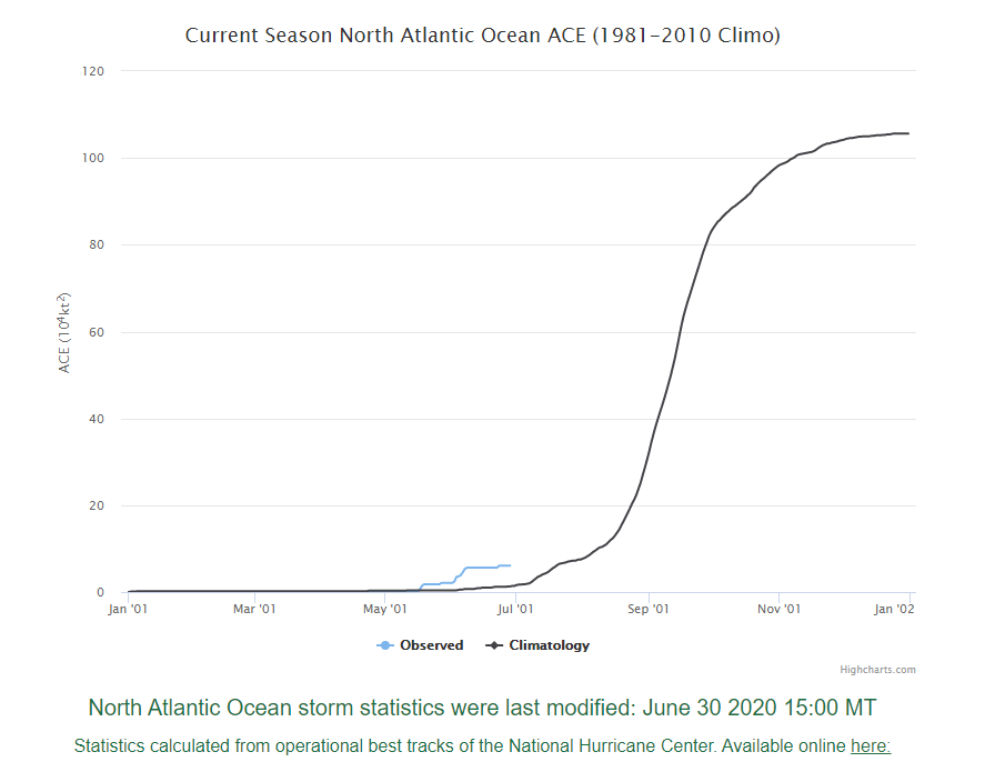
So back to 2020: We have amassed 6.1 units of ACE this season so far. This is normal for about July 20th, so 3 or 4 weeks ahead of schedule instead of 45 days.

Regardless of how you want to slice it, we’re off to a fast start, so this pause is welcome.

Tropical outlook

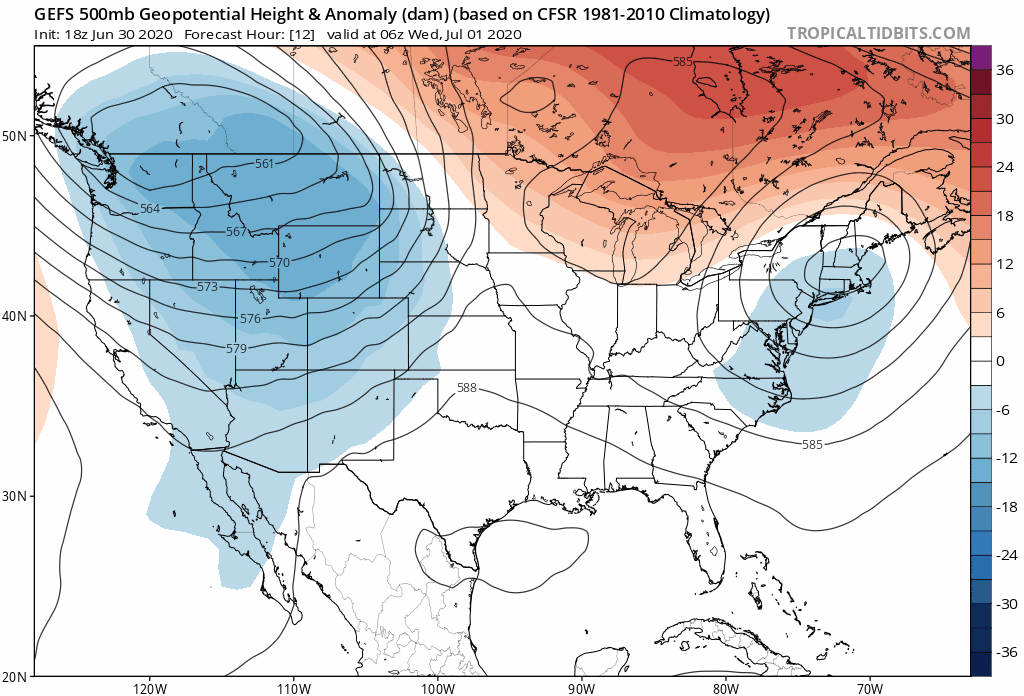
Things won’t stay quiet forever, and it appears the next opportunity for a system will be sometime later this weekend or early next week, and in true 2020 fashion, it will occur in a peculiar manner. An upper level low over the Northeast looks to exit over the next couple days, but it seems like a weak little lobe off the south side either stays trapped over or drifts into the Southeast. Here’s the latest 500 mb GFS Ensemble mean view through next week, looking at what’s happening 20,000 feet up. Note the light blue color over the Southeast. This is showing an upper level disturbance of some type by the weekend.

The upper level pattern shown here by the GFS and also by the European model suggests shenanigans are possible off the Southeast coast early next week. (Tropical Tidbits)

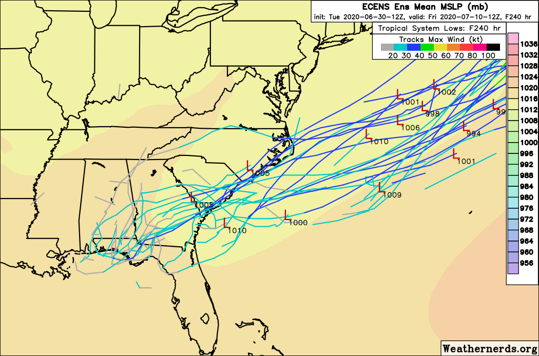
From here, we start to see <waves hands> things happening. It appears this may gradually transition to a surface low as it drifts eastward, off the Georgia or Carolina coast and it’s plausible to think it could become tropical on its exit out to sea. While this will likely have limited impact to any land mass, we have a legitimate shot at having our earliest E/5th storm on record this year.

The European ensemble is particularly enthusiastic about a risk for a depression or weak tropical storm to from from the transitioning disturbance over the Southeast early next week. It likely will move steadily out to sea. (Weathernerds.org)

But that’s it; that’s the tropical update for the next 10 days or so. The overall background state of the Atlantic is one that has become more favorable in recent days. I won’t delve too much into the meteorology here, except to say that we’ve had some shifts in the atmosphere over the tropics that should, in theory, allow for a few more waves. But you’ve seen the Saharan dust here in Houston. It’s out there, and it’s widespread.

Yellow, orange, red, Saharan dust is all over. (University of Wisconsin CIMSS)

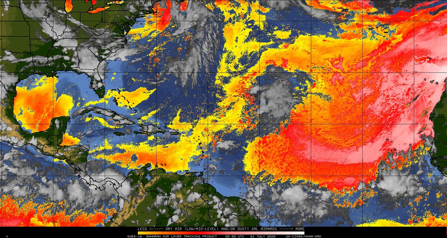
Anywhere you see yellow, orange, or red on that satellite image is an indication that dust is present. It’s all over the Atlantic basin right now, not necessarily abnormal for this time of year. But where you have dust, you have drier air and a less hospitable environment for tropical development. Suffice to say, with this all over, conditions right now are not ideal for tropical development in the Atlantic basin. In addition, you still have a good bit of shear as well. So the basin isn’t completely immune to storms, but it’s rather inhospitable.

Is there anything happening in fantasyland on the models? Nope. Things look quiet right now as we head through early or mid-July. Short of something rogue like this thing off the Southeast coast next week, we don’t expect much through mid-month. So breathe easy here in Houston for the time being. We’ll check back in on things in a week.

The start of July will feel a lot like July in Houston

Good morning. There are few surprises in today’s forecast, as Houston is likely to remain hot and humid through the rest of the week. The trend will be toward hotter and sunnier weather throughout the work week, with early July feeling a lot like July should feel. A few showers may crop up on Independence Day, but the better rain chances likely will wait until Sunday or Monday.

It’s an extremely muggy morning, with apparent temperatures near 90 degrees in Houston. (Weather Bell)

Tuesday

A few, light showers have popped up to the north of Houston this morning, but we expect these to be transient. Thanks to a southerly wind gusting up to 25mph, moisture continues to pump into the region, and this should keep our skies partly to mostly cloudy today. In turn, these clouds will limit high temperatures today to the low 90s. These clouds will also make for another very warm night, with overnight lows unlikely to fall below 80 degrees for most of the area.

Wednesday

A similar day to Tuesday in terms of humidity and southerly winds. However, as high pressure continues to build over the region this should limit the ability of air to rise, and accordingly cut down on cloud cover. Highs will rise into the low- to mid-90s with non-existent rain chances. Additionally, we should see another plume of Saharan dust move into the region, although it will not be as thick as what we saw last Friday and Saturday.

See full post

As pressures increase over Houston, so will temperatures

After the unsettled nature of last week’s weather—from heavy rains to heavy dust—this week holds less intrigue. We’ll see plenty of heat and especially humidity, but likely little rain at least until next weekend.

Monday

Mostly cloudy skies this morning should give way to partly sunny conditions later today. Highs will reach about 90 degrees for most of the area. Perhaps the two most noticeable features will be winds, which may gust from the south at up to 25 mph, and the humidity. Dewpoint temperatures are incredibly sticky this morning, in the upper 70s. By this evening a new plume of Saharan dust will begin to spread across Texas, but it is not as thick as the dust that reached the region last Friday.

Tuesday

A similar day to Monday, with gusty southerly winds and a mix of sunshine and clouds. Highs will reach the low 90s, with rain chances near zero.

Virtually no rainfall is expected in Houston this week, through Friday. (Pivotal Weather)

Wednesday and Thursday

High pressure should really start assert control over our region’s weather. This will likely make for a pair of hot and sunny days, with temperatures in the mid-90s.

Friday

High pressure will begin to back off slightly, but it may not be immediately recognizable in our weather. Expect another hot and sunny day with highs in the mid-90s. Some additional moisture may push in from the Gulf of Mexico, so there may be a slight chance of showers during the afternoon—but probably not.

See full post

Poor air quality today as Saharan dust takes hold

Saharan dust just began to infiltrate the Houston area yesterday, and it was not yet thick enough to obscure the sunset, which proved to be a real treat in spots.

Compare that to yesterday’s sunrise off the coast of Louisiana where dust was thicker.

Your sunrise and sunset mileage during dust events will certainly vary. Should the clouds clear, we expect thick dust today, but it may begin to disperse somewhat toward sunset, so there’s a chance we end up doing well. I think sunrise on Saturday may be fairly nice as well.

Aside from optical treats, there are practical issues with Saharan dust. The Texas Commission on Environmental Quality is forecasting today to be “unhealthy for sensitive groups” in the Houston area. Per the EPA air quality maps, we’re already one notch above that and “unhealthy” in much of the southeast half of the region.

Air quality is already considered “unhealthy” across the region today. It will improve gradually this weekend. (EPA)

If you have allergies, asthma, or other respiratory ailments, you will probably prefer to spend the better part of today indoors. Air quality should be improved a little bit tomorrow, though still probably considered poor. Sunday will be a little better than that.

As far as the rest of the weather goes….

Today

Radar is quiet for a change in the Houston area this morning, aside from a few light showers here and there. There are some storms north of Beaumont and some locally heavy rains in the Victoria area, with just nuisance showers in between.

Radar this morning shows heavier rains well off to our south and west. West of Katy has better odds of storms today than in or east of Houston. (College of DuPage)

Expect the heavier rains to our south and west to continue down there and lift northward today. This should keep those west of the Houston area and west of the hardest hit areas yesterday morning. While we could still see a few downpours or thunderstorms today, the focus will likely be between San Antonio and Columbus. If that should change, we’ll let you know. Yes, you might see some dust or “mud” residue on outside surfaces if it rains. Maybe. Rain would also help improve air quality.

With clouds, haze, or dust, don’t expect much in the way of true sunshine today. Highs will be in the 80s.

Weekend

Both Saturday and Sunday will feature a chance at a shower or thunderstorm. There may be a few small pockets where rain moves slowly and falls heavily for a time. So while many of us may not see much of anything this weekend, it’s not out of the question that a few neighborhoods end up with a couple inches of rain in a short time. I might give an edge to Sunday for having a higher rain chance, but both days will be setup for a few storms. Outside of that, expect a mix of clouds and sun with highs around 90, give or take a couple degrees and lows in the upper 70s.

See full post