Good evening. We don’t have any real good news or bad news tonight on the Laura front relative to Eric’s post earlier today. I would not change any of the scenario percentages he put down either. I was hoping we might have some good news, but alas, we are not there yet. This is explained below.
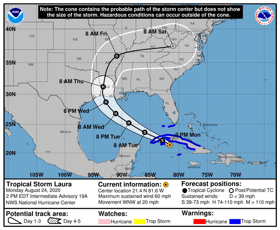
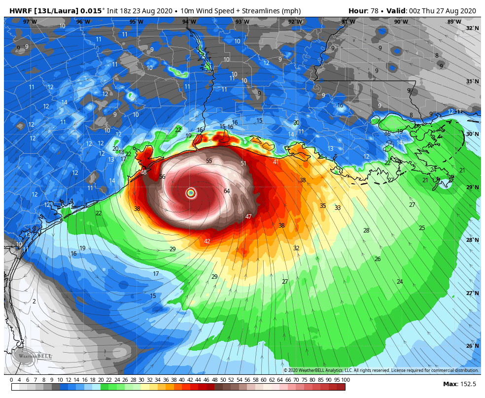
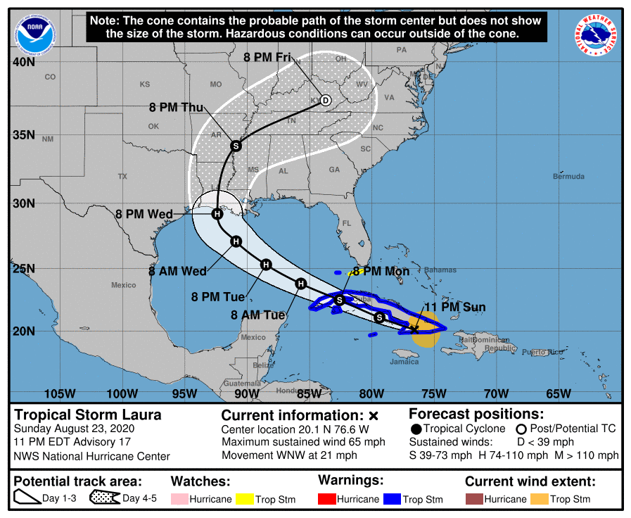
The 7 PM National Hurricane Center Advisory maintains Laura on a course for somewhere between Houston and central Louisiana as a borderline major hurricane Wednesday night.
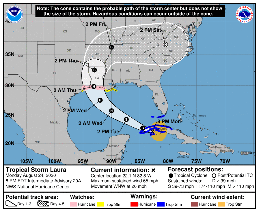
Since our post this afternoon, a Hurricane Watch was issued for Galveston Bay and Port Bolivar into central Louisiana. A Tropical Storm Watch is posted from San Luis Pass through Port Bolivar. And a Storm Surge Watch is posted for all areas north of San Luis Pass.
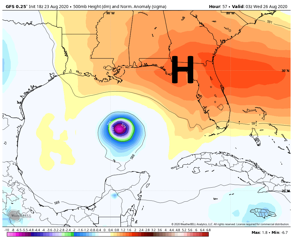
Laura is about to emerge in the Gulf of Mexico this evening off Cuba, entering the healthiest environment it has yet had for strengthening.
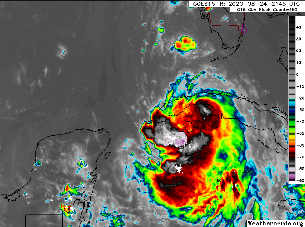
Laura looks a bit ragged overall, but it is putting together a bit of a core tonight, if not something mimicking an eye-like feature. Once this enters the Gulf with high water temperatures and low shear, there is little to hold it back from organizing steadily. That’s our going thought at least. We will see if some slightly “cooler” water that has been present in the eastern Gulf acts to keep the intensification slow and steady rather than explosive over the next day or so. At some point, as long as Laura is able to develop a firm inner-core, we would expect intensification to perhaps become more rapid. Either way, the odds of seeing a major hurricane in the northwest Gulf of Mexico remain pretty substantial.
So what about track?
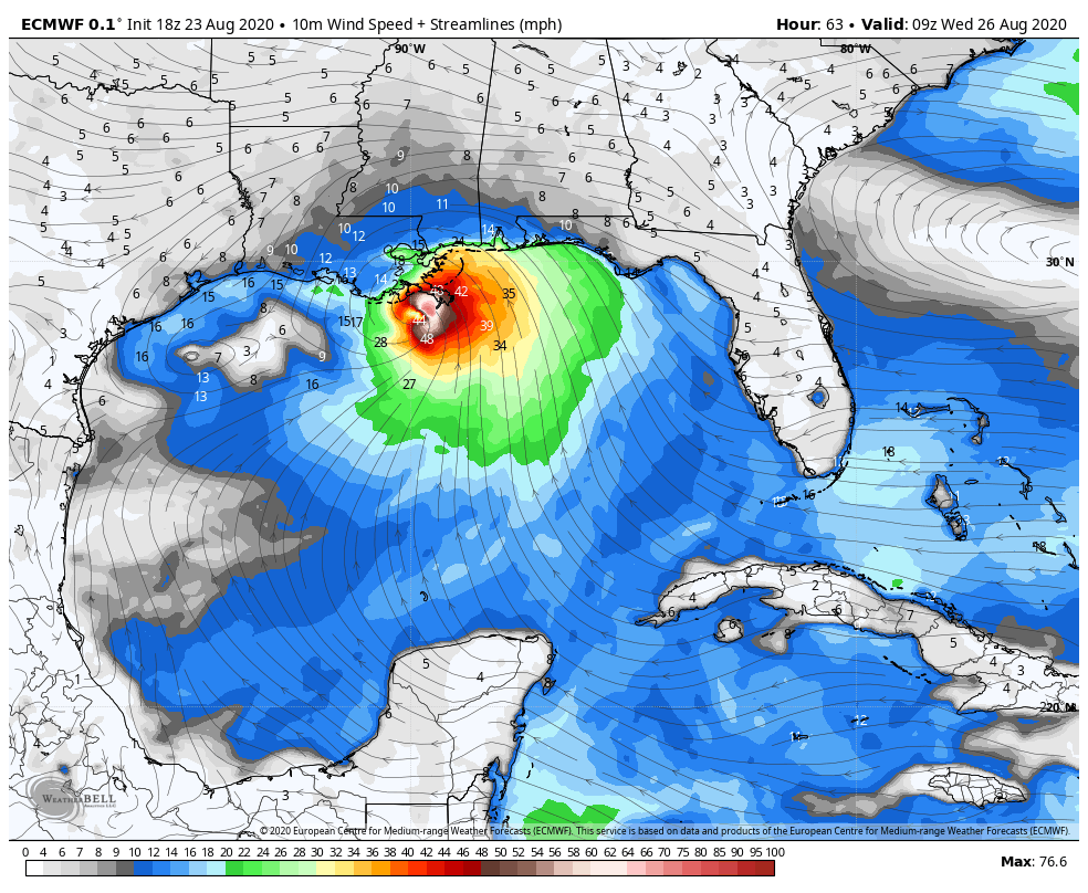
The million dollar question. We will be honest here. We don’t yet feel comfortable. Here is the problem we have been facing. The tropical models, ones that are tuned to handle tropical storms and hurricanes, have been incredibly consistent the last couple days in indicating that the landfall point would be somewhere in southwest Louisiana or close to Port Arthur. This explains why the National Hurricane Center forecast has frankly not moved much either. The thing myself, Eric, and a lot of other meteorologists have been squirming in our chairs over despite this is the European ensemble. The Euro is generally considered the “gold standard” for most things weather forecasting. It runs an ensemble, where the model has the initial conditions tweaked just a little and is run 51 different times. In most years, this model has been really tough to beat. By no means is it perfect; it, too, has its moments.
Well, for the last couple days it has continued to show risks of the storm tracking farther south and west of the tropical models, coming in anywhere from Corpus Christi to Galveston. Today has been no different. The very latest run (pushed out in the last 90 minutes or so) has shifted a little to the north, narrowing some but not as much as either of us would have liked to see for Houston’s sake.
Tracks of the 12z EPS vs 18z EPS lows, tracks in general shift a bit up the coast #Laura images from https://t.co/b4vzQrTBpF pic.twitter.com/XvTF4zunzK
— Allan Huffman (@RaleighWx) August 25, 2020
So how should you be interpreting this information?
The reality is that despite the NHC track focused in Louisiana, despite very consistent behavior from the GFS model and from tropical models, the model we tend to consider the best in the business still shows a distinct risk that Houston and Galveston could end up much too close to the center of Laura and could still take a direct hit. Those are just the facts. That trend we saw in this evening run of the ensemble may continue to shift northeast overnight. We don’t know. But at this specific point in time, you should by no means let your guard down with respect to this system. You will need to be ready to act quickly tomorrow in case something changes. Fortunately, we should get our answers tomorrow morning or early afternoon on how real a risk this is for Houston or if it will be another in a litany of close calls for our region. Eric will have the very latest in the morning, no later than 8:00 AM.