Here comes a dying front, and at least 10 more days of summer

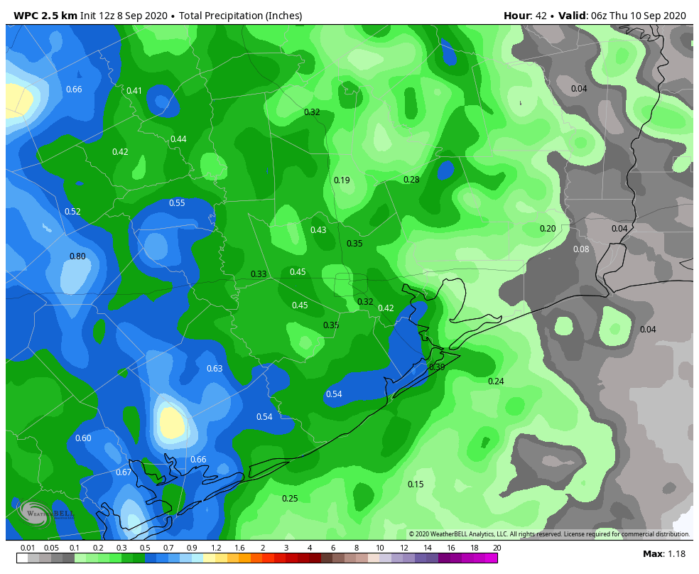
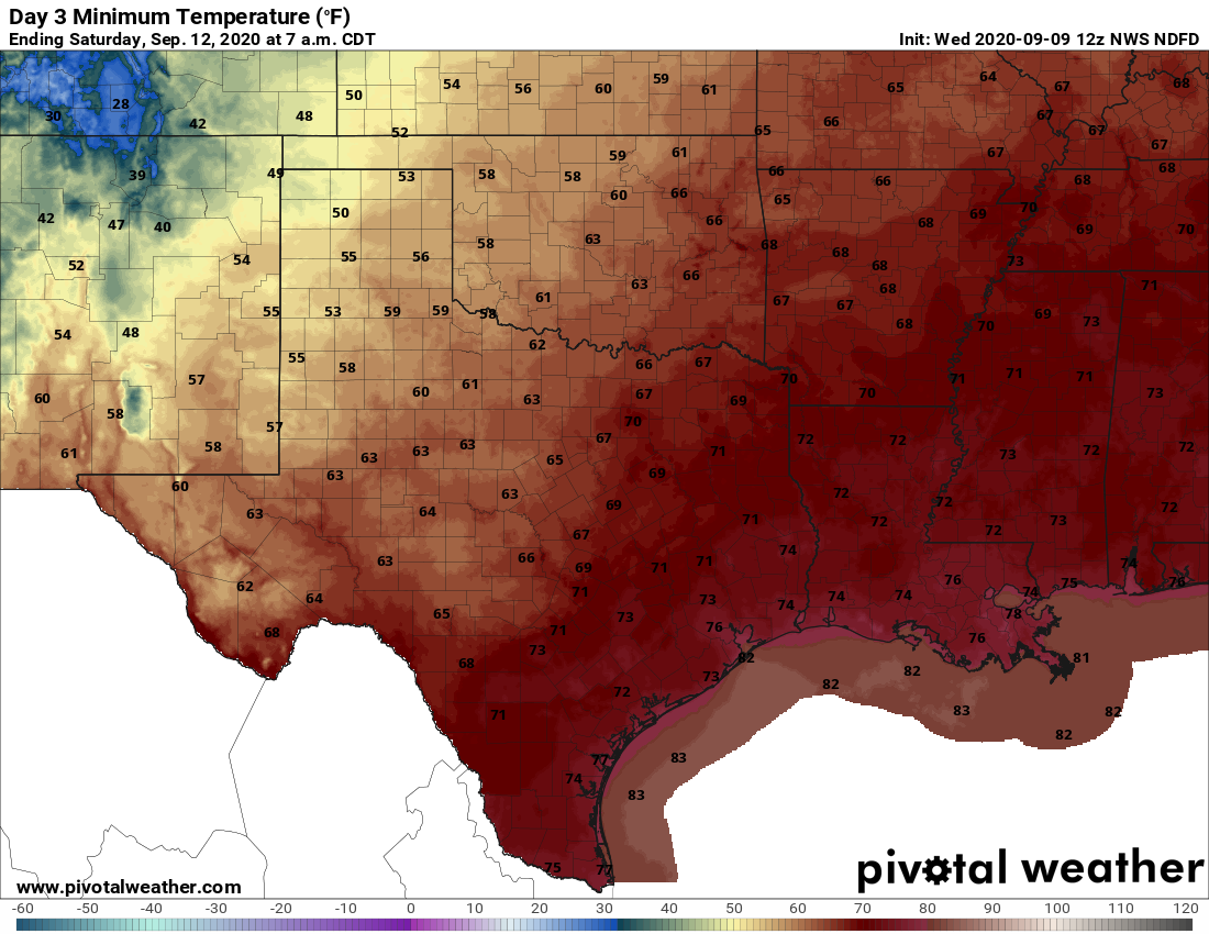
Today is such a disappointing day, my friends. As we look off to the west, we’re going to see an approaching front that, by all appearances, is going to die on our doorstep. The map below shows the likely extent of the front’s cooling by Thursday morning at 10 am CT. If the front makes it any further eastward—which is possible, although not particularly likely, we’ll consider ourselves lucky. The crushing part of all this is that our next chance for a real front probably will not come for another 10 to 12 days.

24-hour apparent change in temperatures shows the front’s extent by Thursday morning. (Weather Bell)

Wednesday

Today will be a day much like Tuesday, which is to say partly sunny skies with a decent chance of rain showers. However the heaviest rains will remain west of our region, over Central Texas, along the approaching front. The additional clouds should help to moderate temperatures a bit locally, with highs perhaps only reaching the low 90s. The front itself will likely bring a wind shift overnight, as winds blow from the northeast. But alas, this is likely to bring little sensible change in the weather in Houston.

Thursday

If you live north or west of Houston you may have some slight hope of a drier and cooler day, but for the rest of us Thursday will likely be a hot and sunny day with highs in the mid-90s. Rain chances will be in the 40 percent range. Thursday night may see some moderate regional cooling overnight, which is to say low- to mid-70s rather than upper 70s. And that will be the probable extent of the front’s influence on our weather—enjoy!

Friday morning’s low temperatures across the region. (Pivotal Weather)

Friday and Saturday

Summer continues, with a pair of sunny days, highs in the mid-90s, and relatively low rain chances.

Sunday and beyond

An upper-level low pressure system may combine with increased moisture at the surface to drive more widespread showers from the Sunday through Tuesday period next week, although our overall confidence in the details is low. My yard could use a few inches of rain so I’m hoping this particular forecast verifies.
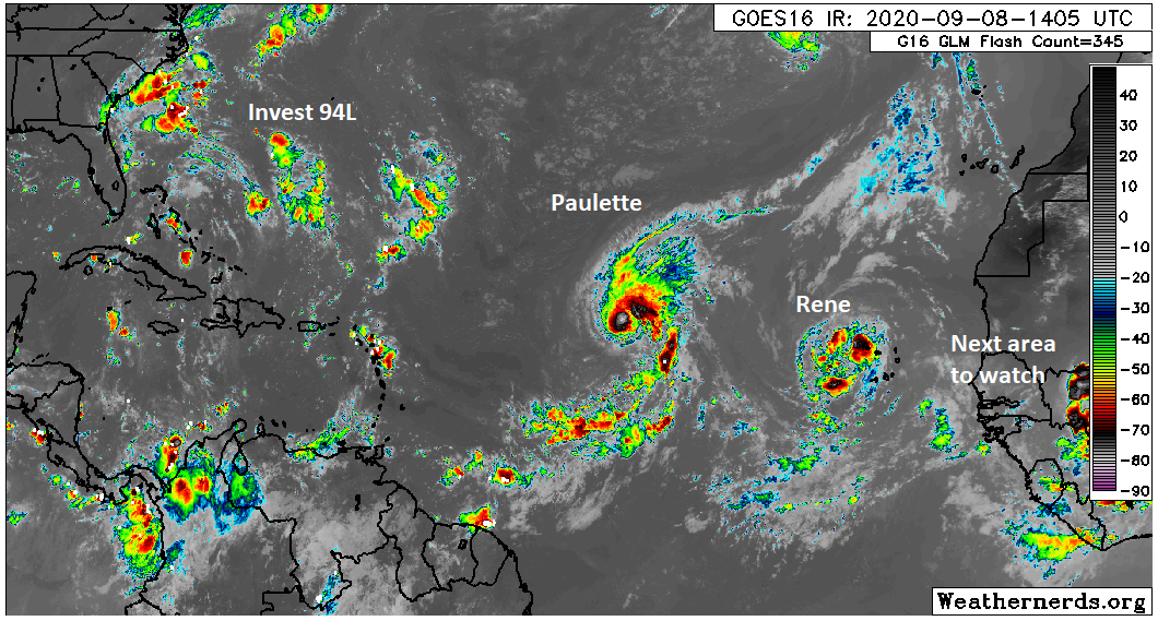
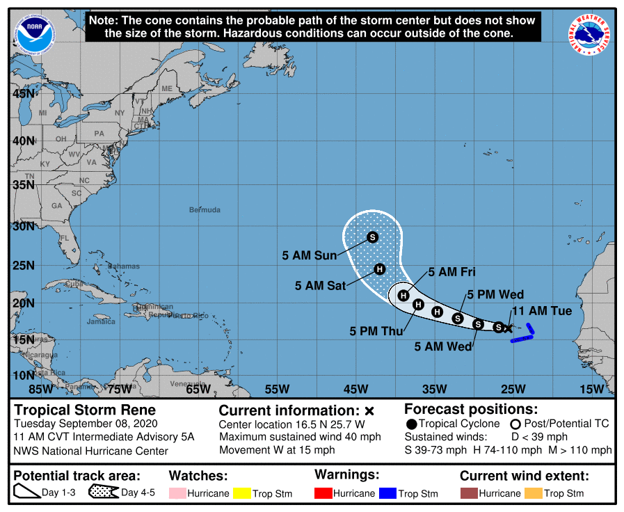
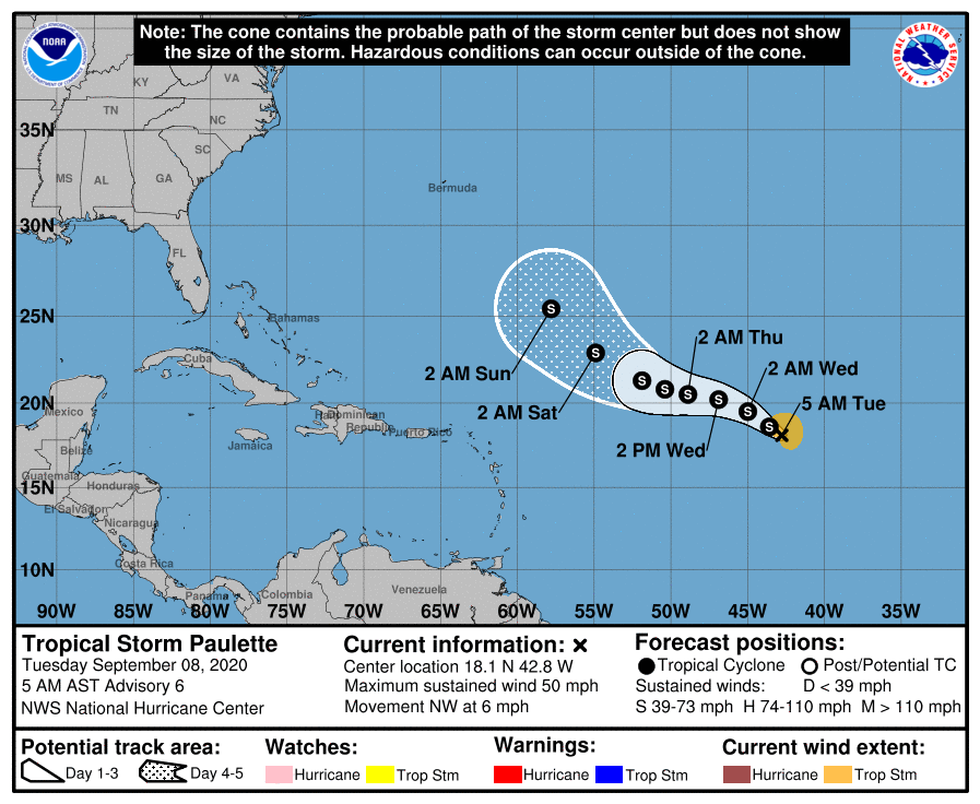
Tropics

There has been no real change since Matt’s excellent overview posted on Tuesday. We still see no immediate threats to the Gulf but we’re remaining watchful as we reach the peak of the 2020 season.

Eye on the Tropics: The peak of hurricane season is here

Historically, this week marks the statistical peak of the Atlantic hurricane season. This year looks to live up to the hype as well.

The Atlantic looks like a basin that is at the peak of its season. (Weathernerds.org)

We have two tropical storms in the Atlantic today and there are likely to be at least a couple more before next week. We don’t think that any of these systems will seriously threaten the Gulf, however it is important to keep monitoring things, particularly with respect to the third system in line.

Tropical outlook in a sentence

Tropical Storms Paulette and Rene will likely be followed by a third system this week off Africa, and while none looks especially likely to make it to the Gulf, it would be wise not to write them off completely, particularly the third system, given the recent model difficulties we’ve seen.

Tropical Storm Rene

I want to get Rene out of the way first because I think this one has the least future of note, as it relates to the U.S.

Tropical Storm Rene is likely heading out to sea, though it is expected to become a hurricane as it does so. (NOAA)

Tropical Storm Rene has 40 mph maximum sustained winds, and it is impacting the Cabo Verde Islands today. It is expected to track west and then turn northwest and north as it finds a “weakness” in the upper air pattern. The pattern does get a bit convoluted late, so Rene seems to strike me as a storm that could hang around in the open Atlantic for awhile, possibly taking a weird track as it does so. But it will not be a threat to the U.S. or Caribbean.

Tropical Storm Paulette

Tropical Storm Paulette has winds of 50 mph, so it’s a bit stronger than Rene. It’s also farther west. Paulette’s future is a little more difficult to project.

Paulette is expected to track off to the west and eventually turn north. While it should go out to sea, there is a chance it could come a bit farther west. (NOAA)

Paulette is going to be steered back to the west a bit by a building area of high pressure in the upper atmosphere. The storm will then have an opportunity to escape off to the north by the weekend as another area of high pressure off the U.S. East Coast gets eroded by a system moving through New England. I think Paulette’s track is of slightly lower confidence by this time. My doubt rests in Paulette’s intensity. With this pattern, I do wonder if Paulette’s weak intensity this weekend will allow it to escape underneath all that nonsense off the East Coast, which would allow it end up farther south and west of the forecast. In that situation, Paulette’s turn out to sea might wait to commence until it gets between the U.S. and Bermuda, rather than east of Bermuda as currently shown. While it would still likely end up out to sea, it could potentially create a bit more heartburn for folks on the East Coast. We’re about a week away from Paulette getting west of Bermuda if that were to happen, so it’s a lot of speculation. For us in the Gulf, Paulette probably poses no meaningful risk, but I’d at least keep a slight eye on this if I lived on the East Coast.

See full post

Widespread showers possible today, front likely to miss on Thursday

Good morning. We’re now into the second week of September. A few of us had a friendly debate on Twitter this weekend about whether August or September was the worst month of the year in Houston, weather-wise. I’m definitely on Team August, for the simple reason that at least in September there is hope for a front and a hint of fall. Matt and several others said September is the worst for the very reason that some semblance of fall should be here in September, but it often is not. So what do you think? In any case, this week will be difficult as we watch a dying front approach the area, but likely not make a significant impact on our weather.

Tuesday

For some, this will be quite a wet day. We should see on-and-off rain showers across much of the area with a moist air mass and small feature in the atmosphere that will promote rising air. Some areas may see 1 to 2 inches of rainfall, while others see little to no precipitation from these hit-and-miss showers. Where it’s not raining, partly sunny skies should help to push high temperatures into the low-90s. Low temperatures Tuesday night will be in the upper 70s to around 80 right along the coast. Winds will be light out of the southeast.

NOAA forecast for cumulative rainfall between now and Thursday morning. (Weather Bell)

Wednesday

This is another potentially wet day as the overall air mass remains fairly unsettled upstream, with a fairly strong front pushing into Texas. This may help generate some additional showers and thunderstorms over the Houston area, keeping highs again to around 90 degrees or perhaps a little bit higher.

See full post

Sorry Houston, no strong front is coming this week

Hi everyone—just a quick Labor Day morning update here.

We’ve got some good news and some bad news, and we’ll start with the latter. If you’ll recall last week, we were 50-50 on whether a fairly robust cool front would push through the region. Alas, we’re now pretty confident it won’t make it. Summer, such as it is in Houston, will continue for awhile longer, albeit with highs mostly in the low 90s rather than the mid- or upper 90s.

The good news is that although we’re on the cusp of two more named storms forming in the Atlantic tropics, continuing this hurricane season’s record pace, we see no threats to the Gulf of Mexico over the next several days at least. This week is the historical peak of hurricane season, and for Texas the threat should be ebbing in about three or four weeks.

As for our weather this week, Labor Day will see a fair amount of sunshine and highs warming into the mid-90s. With slightly weaker high pressure over the region, some slow-moving showers and thunderstorms could produce 1 or more inches of rainfall today, but things will again be hit or miss. Tuesday should be similar.

The cold front is going to get hung up in Central Texas on Thursday. (Weather Bell)

The latter half of the week will be influenced by a cold front dropping into Texas and approaching our region. However, with the front likely stalling out around the Interstate 35 corridor, we only expect very slight effects locally. For now we’ll go with highs in the low 90s, and with lows dropping into the mid-70s, and a smattering of rain chances.

We’ll be back tomorrow with a full update!