A smattering of showers, as we await clarity on next week’s possible cold front

We certainly have not been in a true “drought” this summer, but at times, we’ve flirted with some extended dry periods. We seem to be in one of those now. Over the last 60 days, we have seen mixed results in the rainfall department in our area.
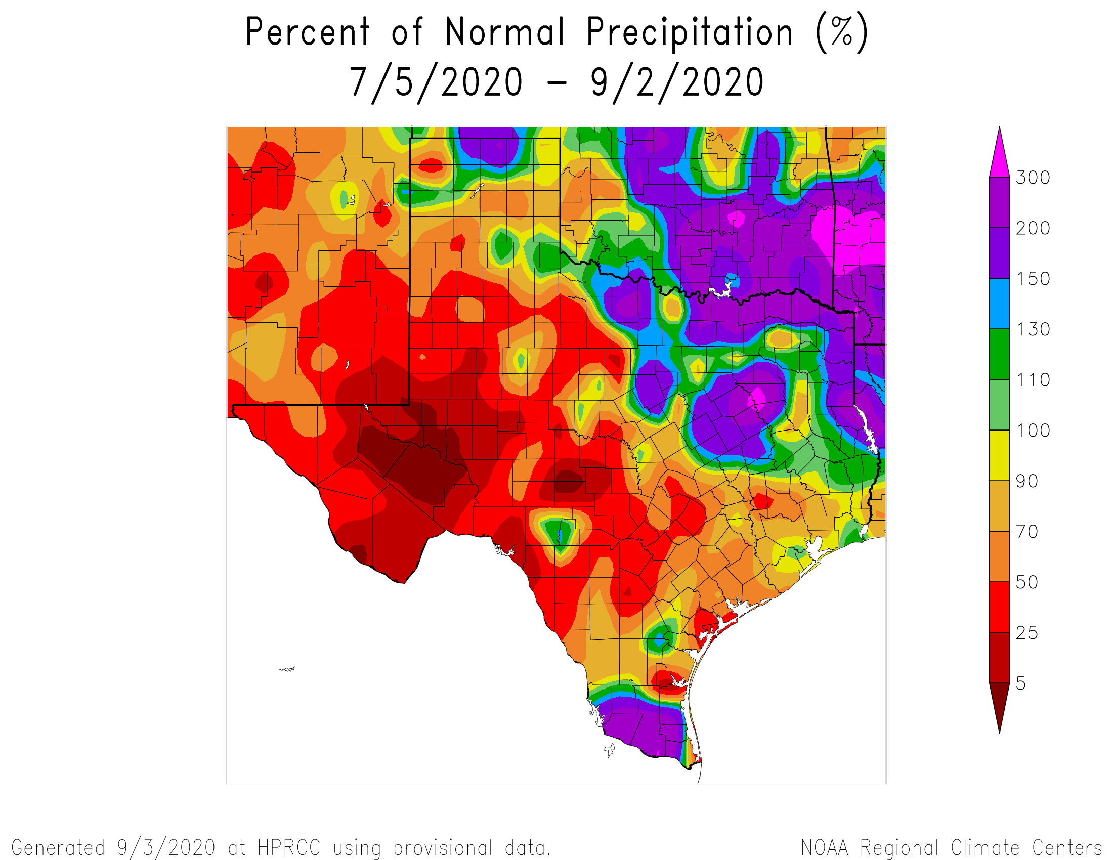
Over the last 2 months, some parts of the Houston area have seen near normal rainfall, while others have seen about half of normal. (High Plains Regional Climate Center)

Parts of the Houston area, particularly down toward Hobby and Clear Lake have seen near average rainfall over the last two months. But, if you go up into western Montgomery County, some places have seen less the 50-percent of normal rainfall. Most of the Houston area is running drier than normal, and while parts of Texas have seen decent rainfall this week, most of Greater Houston has not. At least many of us will see a little rain in the next couple days, as we try to decipher the potential cold front riddle for next week.

Today

If you’re like me, perhaps you were woken up by thunder at 4:15 or so this morning. There have been a few storms focused mainly on the east and north sides of the city so far today. Places like Baytown, Pasadena, and Galena Park have seen around or above a half-inch of rain from those showers.

The rest of today will be characterized by scattered showers and storms. In trying to pinpoint any sort of rhyme or reason to how they’ll behave today, it would seem that they may try to focus in the Highway 59/I-69 corridor or just south this morning before slowly focusing more north and west as the day wears on.

Some of you won’t see any rain. Others could pick up an inch or two with some heavier downpours possible. Most of us will see slightly cooler weather today. Humidity will remain quite high, however, so don’t expect any sort of comfort in the Houston area. But, hey, at least Galveston finally dropped below 87 degrees this morning. Look for highs in the lower 90s and heat index values again jumping above 100 degrees, albeit somewhat less oppressive than earlier this week.

Weekend

Both weekend days will carry at least a chance of showers or a thunderstorm. As low pressure in the upper atmosphere gradually weakens and slips away, we’ll see a little less support for storms than perhaps we see today. Look for scattered showers both days, but with gradually less coverage. Many areas may not see much rain at all this weekend. Right now, places away from the coast look to have higher odds of rain, with a gradual shift south and west on Sunday.
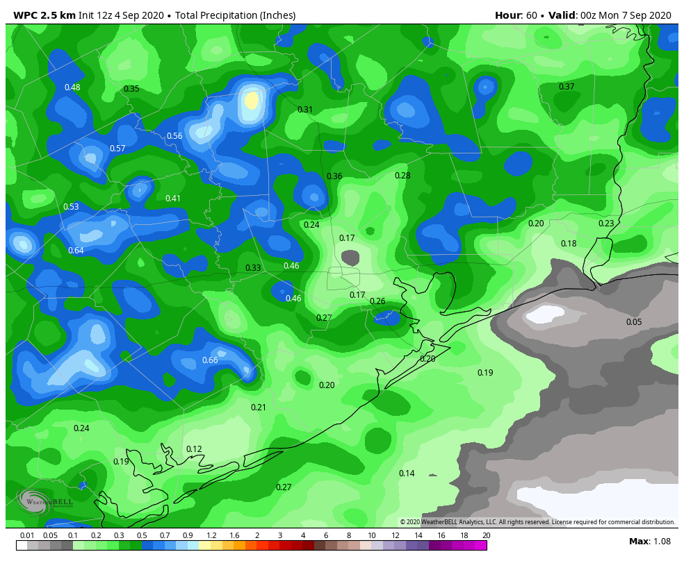
Rainfall this weekend will total about a quarter to half-inch on average, with some seeing less and others seeing a bit more. (Weather Bell)

Total rainfall when all is said and done will likely average around  a quarter to half-inch of rain for most of the area. Again, some will see less, some a bit more. That’s just the nature of these types of setups. High temperatures will be in the low- to mid-90s this weekend, with our uncomfortably warm overnights continuing.

See full post

Two questions: Will it rain this weekend, and will the front really make it?

The watchword for Houston’s weather in the coming days is uncertainty—with the main questions concerning whether it will rain locally over the next few days, and whether a front will push through Houston on Wednesday or so of next week.

Thursday

It’s going to be another very warm day along the coast, with highs in the 90s and heat indices pushing into the low 100s. High temperatures elsewhere will likely get into the mid-90s, tempered somewhat by more clouds in the sky. Forecast models are pretty inconsistent, but given the available moisture in the atmosphere I’d guess about one-third of the area sees some form of light to moderate precipitation later today. This should help moderate temperatures slightly.

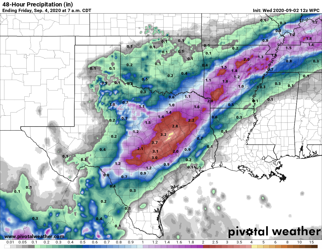
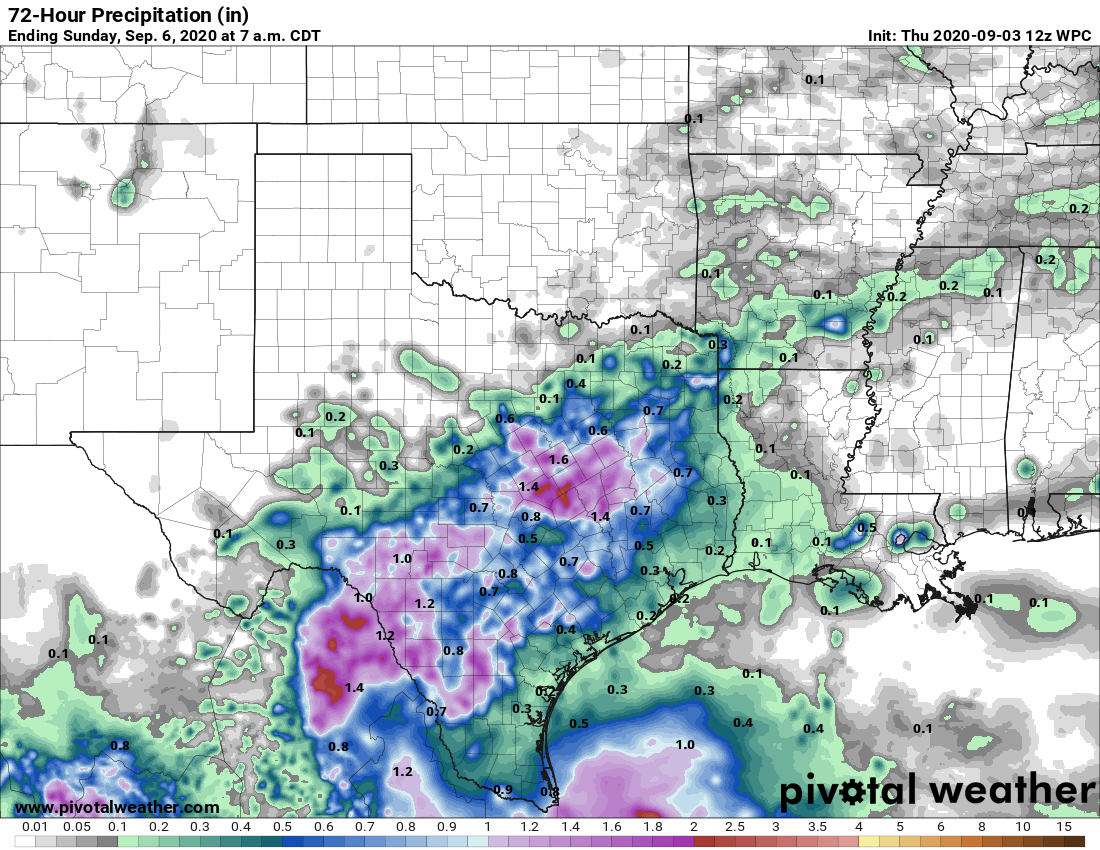
Here is NOAA’s rainfall forecast for now through Saturday. Calibrate your expectations accordingly. (Pivotal Weather)

Friday and Saturday

By Friday, a nearby upper-level system in conjunction with a weaker capping inversion should increase coverage of rain showers and thunderstorms to 40 or 50 percent. These will most likely occur later during the afternoon hours, with the peak of daytime heating. I still think skies will be at least partly sunny, and we can probably expect highs to get into the mid-90s. Overnight lows will remain sticky and warm, in the upper 70s except immediately along the coast.

Sunday and Labor Day

The second half of Labor Day weekend will likely see more sunshine as high pressure amplifies a bit. Expect a pair of warm, summer days with plenty of sunshine and highs in the mid- or upper-90s. We’re not going to rule out some scattered showers along the sea breeze, however.

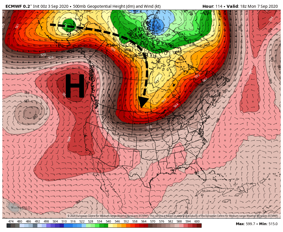
European model 500mb forecast for Monday. (Weather Bell)

Will the front make it?

Oh, my friends. I would love nothing more than to tell you that fall’s first cold front will definitely come barreling into Houston six days from now. But the fact of the matter is that this possibility hinges the strength of a ridge of high pressure near Canada and Alaska early next week, and the extent to which a trough of cooler air can penetrate into the central United States. Right now the models are parsing a pretty fine line on whether that happens or not to allow cooler air to make its way all the way down to us—so we’re sticking to our 50-50 prediction of whether a front makes it.

Houston’s very hot weather will begin to ease in the coming days

Good morning. The main story of our weather continues to be heat—Houston’s high temperatures for most of the last week have reached 99 degrees or above—but after today our hottest weather and extreme heat indices should be in the rear view mirror. We expect to see a few more clouds today, and then better rain chances starting tomorrow should help to temper our peak daytime heating just a bit.

Wednesday

A large complex of storms that has produced several inches of rainfall over North Texas should continue to sag southward this morning. But most likely these storms will stall out to the northwest of our area—the rains will probably reach a line from Sealy to Conroe before dying out. Areas northwest and along this line may see some additional on and off rainfall through this evening. Otherwise it should be a partly to mostly sunny day for most of the metro area, with high temperatures in the mid- to upper-90s. Winds will again blow from the south, gusting perhaps to 20 mph due to a tight pressure gradient.

On Wednesday and Thursday the heaviest rains should remain northwest of Houston. (Pivotal Weather)

Thursday

As more moisture moves into the atmosphere we’re likely to see more clouds on Thursday, and this should help to moderate temperatures slightly. At least some scattered showers will be possible as highs get into the low- to mid-90s. Nighttime lows will remain sticky, in the upper 70s.

Friday

A bit more of a disturbed atmosphere on Friday, in conjunction with ample moisture in the atmosphere, should lead to more widespread showers on Friday. Accumulations will likely vary widely across the region. Highs will depend upon the extent of rainfall at your location.

Saturday, Sunday, and Labor Day

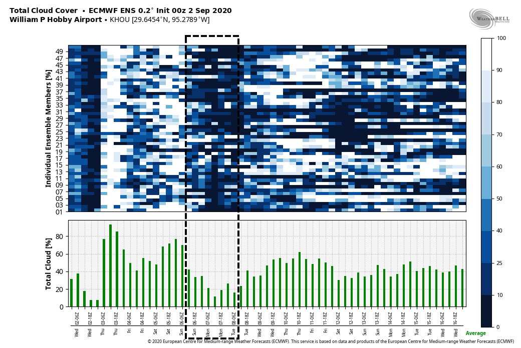
The weekend weather looks fairly standard for this time of year, with partly to mostly sunny skies and highs in the low- to mid-90s most likely. We’ll have some decent rain chances—perhaps 30 percent?–each day along the sea breeze.

Sunday and Monday of Labor Day weekend should see plenty of sunshine across the metro area. (Weather Bell)

Next week

We’re still watching the potential for a fairly robust cool front to arrive in Houston later on Tuesday or Wednesday of next week. If it makes it, this front will provide a nice shot of drier and cooler air, but it remains too close to call or guarantee a week out.

Laura wrap-up

As some of you may know, for my day job I write for a publication called Ars Technica. On Tuesday, we published a feature on Hurricane Laura, and the very close call on whether the region enacted a more widespread evacuation. And it was very close.

Eye on the Tropics: So now what?

It’s kind of crazy to think that our last full tropical update was two weeks ago, and we noted how things were about to ramp up. For many folks in Louisiana, the world is a much different place today than it was then. For Houston, I think we had a moment there. You exhale, but then you realize that nothing has really changed, and all it takes is one more storm to bring us right back to where we were sitting in the days before Laura. So will that happen? Probably not, but let’s walk through things.

Tropical outlook in a sentence

We expect several systems to develop over the next week or two across the basin, but right now only one of them is worth seriously watching and even it will be racing against the potential cold front next week.

Potential Tropical Cyclone 16

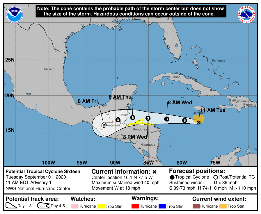
The system that we referred to as Invest 99L yesterday has been classified as Potential Tropical Cyclone 16 (PTC 16) in the Caribbean this morning, meaning it is expected to become a depression or named entity soon. It looks fairly healthy on satellite, and it will likely develop over the next couple days.

Potential Tropical Cyclone 16 is not a threat to the Gulf of Mexico, but it will deliver heavy rain to parts of Central America. (NOAA)

Fortunately, thanks to our oppressive heat in Texas, with sprawling high pressure over the Gulf of Mexico, this will keep PTC 16 well to our south. No need to worry about this coming to the Gulf. So what is coming after this system?

See full post