Good morning. Thank you for your patience with this morning’s post. With dry air and temperatures dropping into the low 50s in my neck of the woods—and no certainty for when that might happen again—I cranked out a very long training run this morning. The roads were certainly nice and quiet at 4 a.m. And our weather, too, will be mostly quiet in the days ahead, with little excitement.
Wednesday
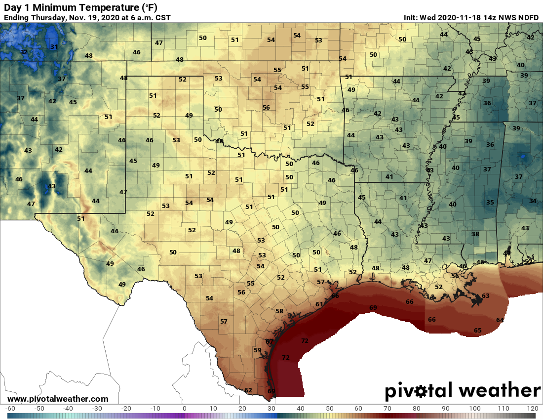
Skies will again be mostly sunny on Wednesday, but temperatures will be a little warmer, and the air a little more humid, thanks to subtle shift in winds, which are now blowing from the east at 5 to 10 mph. Low temperatures tonight will probably drop down into the 50s for most of Houston, but conditions will be warmer near the coast.
Low temperature forecast for Thursday morning. (Pivotal Weather)
Thursday and Friday
As winds shift to come from the southeast on Thursday, we may see a few more clouds, and humidity levels will continue to creep up. Highs both days will reach about 80 degrees, and lows will likely only drop into the 60s for all but the most inland of areas.
Saturday and Sunday
The weekend will see more of the same, which is to say mostly sunny skies, and highs around 80 degrees. Nighttime temperatures will again be in the 60s. The biggest outstanding question is the timing and strength of a front that probably will push into Houston on Sunday night or Monday morning.
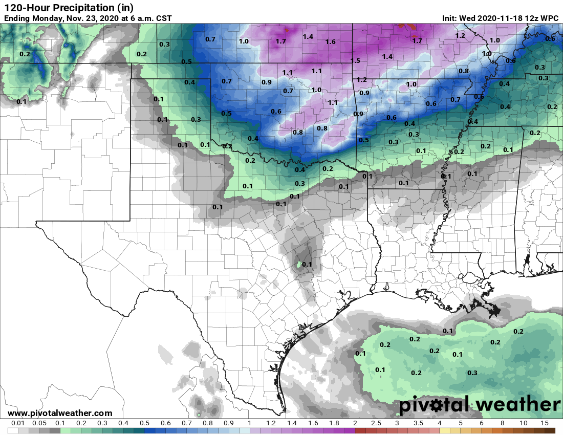
The models are generally in agreement that the front will in fact make it through Houston, although that is not something I’d bet the farm on. Not that I own a farm. In any case, this front probably will drop highs back into the 70s, and lows into the 50s for most of the area. Emphasis on probably. Will we see any precipitation with the front? Maybe, but I think chances are only about 20 percent, and any accumulations will be light. We’ll try to have a better answer on Sunday’s rainfall potential tomorrow.
The rainfall outlook for now through the weekend still looks dry. (Pivotal Weather)
Thanksgiving week
Given the general uncertainty surrounding Sunday night’s probable front, the forecast becomes pretty murky, pretty quickly next week. The models are hinting at another front possibly making it through late Wednesday or on Thursday—which would be Thanksgiving. I sort of hope a front makes it, because otherwise Thanksgiving could be 80 degrees and humid. Perhaps some clarity will emerge on this in a day or two.
We’ll be back to our normal schedule tomorrow! Also, I think we’ve solved the formatting issues with the daily emails, but if you’re still have problems please let us know.
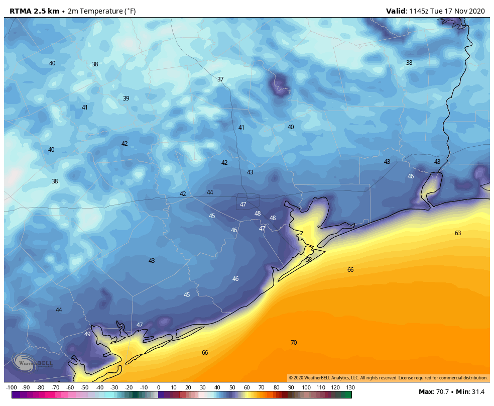
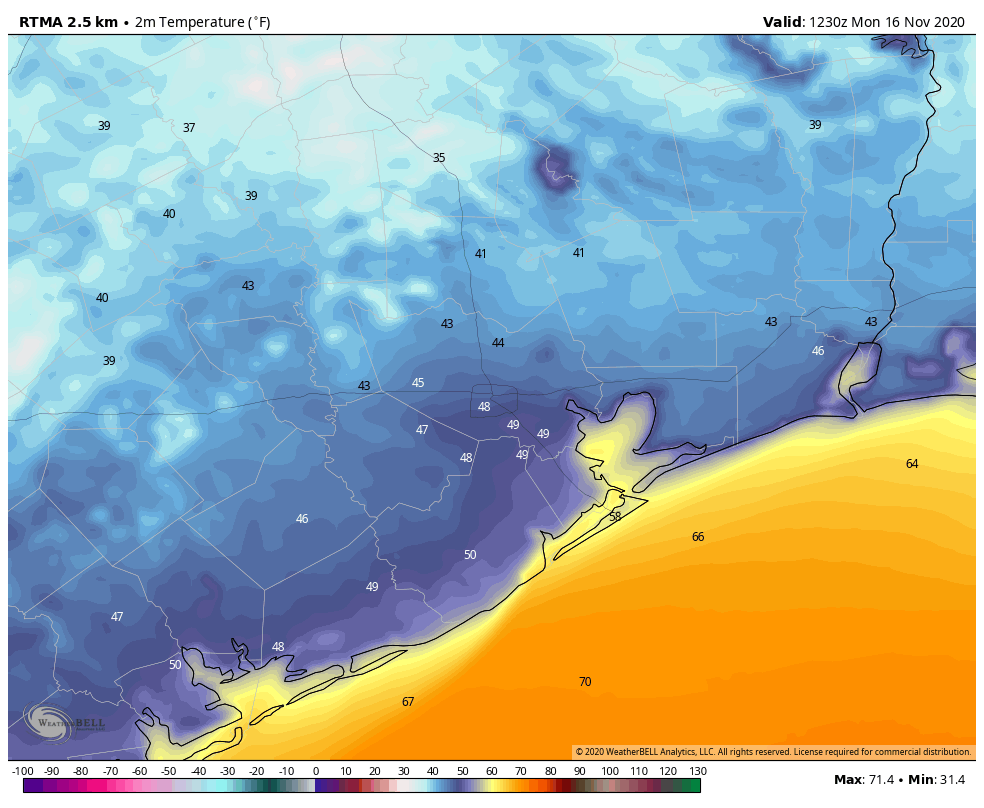
Good morning. We’re seeing some of the region’s coolest temperatures of November this morning, with lows in the 30s for outlying areas, and 40s in the city of Houston. We will see a gradual warming trend heading into the weekend, but after that the forecast remains somewhat uncertain. Note: Tomorrow’s post will arrive an hour or two late, which seems OK because not much is happening with our weather.
Houston enjoys a cool start to Tuesday. (Weather Bell)
Tuesday
Conditions today will offer another fall delight for the Houston metro area, as sunny skies nudge high temperatures into the mid-70s. With light northeast winds, our air will remain very dry by Houston standards, as dewpoints crash into the 30s again this afternoon. This will not last, of course, but the region should experience one more cool evening, with temperatures perhaps a 3 to 5 degrees warmer Tuesday night than Monday.
Wednesday
Winds will shift to come more from the east on Wednesday, but this still will be another pleasant day with sunny skies and highs in the mid-70s. Lows on Wednesday night, however, may not fall below 60 for much of the region.
Thursday and Friday
The onshore flow begins to kick in on Thursday, bringing the region a pair of partly sunny days to end the work week, with highs around 80 degrees, give or take. Lows generally will be in the 60s as some humidity returns.
Saturday and Sunday
This weekend should continue the trend, in terms of partly to mostly sunny days, with highs in the general vicinity of 80 degrees. We can’t entirely rule out some rain showers, although chances for both days are probably only about 20 percent.
Next week
I’d love to be able to give you a confident forecast for next week, including the Thanksgiving holiday. Unfortunately, the pattern is not at all clear, and the model guidance is all over the place. Our first uncertainty is the progression of a cool front on Sunday night or Monday. How far does it get?
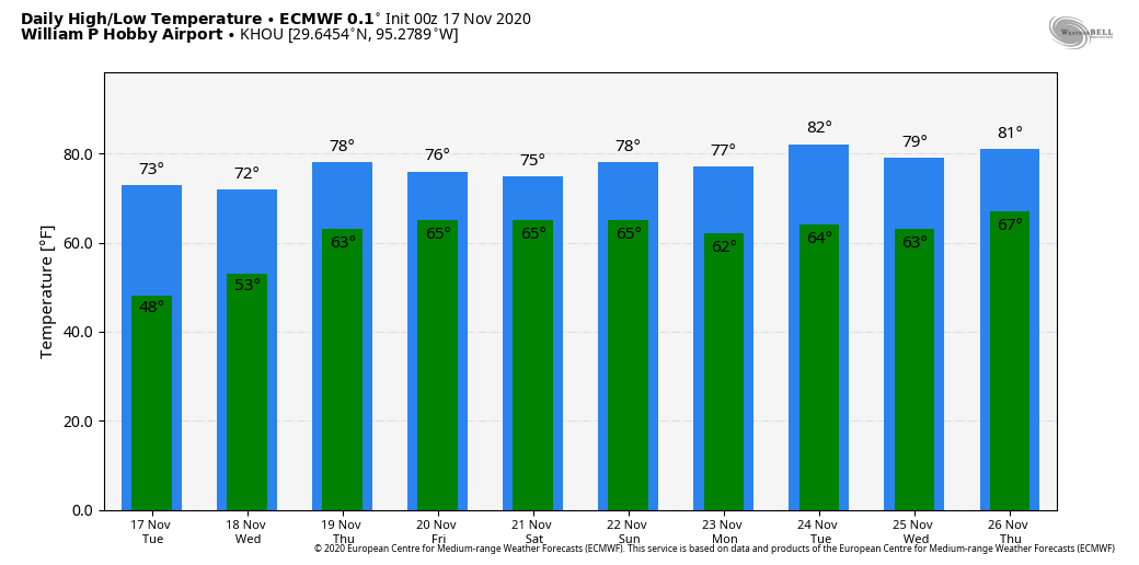
This may be another one of those situations where a front gets close to Houston and stalls, or actually makes it all the way to the coast. The next question is whether a reinforcing front makes it to Houston around Wednesday, and pushes all the way through. The latest, high resolution run of the European model, shown below, suggests that no fronts make it over the next 10 days, which would lead to a steamy Thanksgiving.
Ten-day temperature forecast from the European model. (Weather Bell)
I don’t think this is going to happen, as I bet at least one front makes it through the region next week by Wednesday or so, and this probably would bring us cooler and drier weather for the holiday weekend. There is some support for this even in the European model’s ensembles, which I’ve included below. The bottom line is that we’re just going to have to wait a day or two, at least, to get some clarity.
European model ensemble forecast shows some support for a Monday front. (Weather Bell)
Fundraiser
Our annual fundraiser to support Space City Weather is ongoing. Thanks for your continued support!
It is quite a cool morning across the region, with temperatures ranging from the upper 30s far north of Houston—in places such as Conroe and Huntsville—to the 50s right along the coast. We’ll enjoy very dry air through about Wednesday before a warming trend begins heading into the weekend.
Temperatures at 6:30am CT on Monday morning. (Weather Bell)
Monday
Ample sunshine will help our region warm into the low- to mid-70s today. With high pressure dominating our area, winds will be light, out of the northeast. We can expect another chilly night, with temperatures dropping down to about the same levels on Monday night as Sunday night.
Tuesday
This will be another sunny, cool day. Highs may be a degree or two warmer than on Monday, but as our light winds begin to veer and come from the east, temperatures Tuesday night will begin to moderate a bit. I would anticipate lows in the mid-50s in Houston—warmer near the coast, and cooler inland.
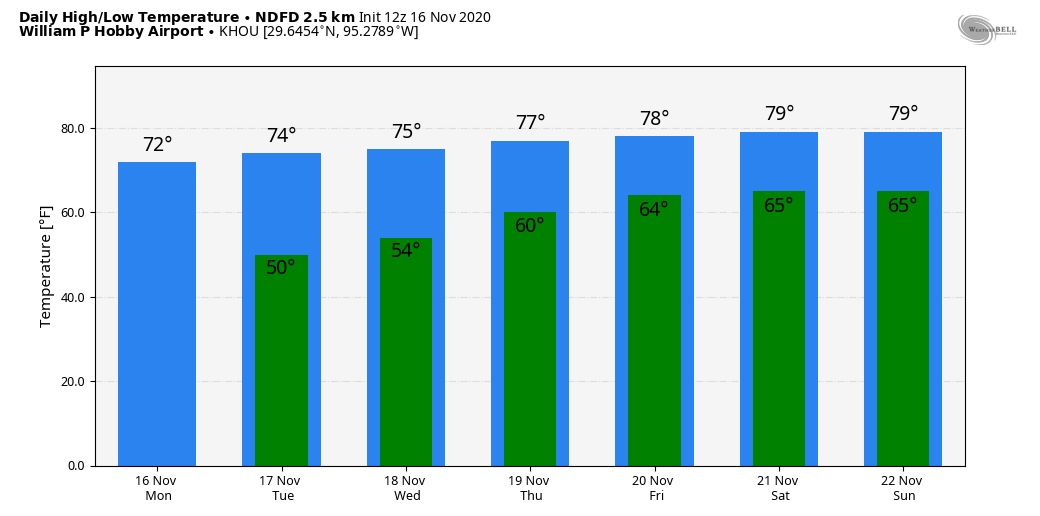
Wednesday, Thursday, and Friday
As the onshore flow becomes slightly more pronounced during the second half of the week, our temperatures will warm, and humidity levels will begin to creep up. By Friday, we should see high temperatures near 80 degrees, with lows only dropping into the mid-60s. Skies should remain mostly sunny throughout the week.
Saturday and Sunday
The weekend may see some more clouds, and possibly some rain chances. Right now I’d ballpark highs near 80 degrees, with a 20 percent chance of rain on Saturday, and somewhat higher chances later on Sunday or Sunday night. That’s when I think—emphasis on think, because there’s not agreement yet, and it’s a ways out—our next front will push through. There is a healthy signal for some rainfall with this front, but it’s far too early to say this with any confidence. Certainly, we could use the rain.
Houston will see a warm-up in nighttime temperatures this week. (Weather Bell)
Next week and Thanksgiving
Most of the modeling guidance suggests we’ll warm up fairly quickly for the front, so unless another front arrives by the middle of next week we may be looking at a warm Turkey Day, with highs in the upper 70s perhaps. However I think there’s a reasonable chance another front will make it in time for Thanksgiving, to allow for a more festive feel outside. We shall see.
Tropics
Hurricane Iota is not going to come near the Gulf of Mexico, but the rapidly intensifying storm is nonetheless worth noting because it will make landfall in very nearly the same location of Honduras tonight as Hurricane Eta made two weeks ago. We have seen explosive intensification of this storm, and Iota now has 155-mph winds. This will bring destructive winds and flooding to Central America. Just terrible.
Before I get into the weather, I really just want to say how floored Eric and I both are by the support you’ve shown us as we kicked off our annual fundraiser this week. We are truly humbled, and we cannot thank you enough.
Jumping into the weather, it’s pretty benign around here, and it looks to stay that way into next week, though with some changes that we’ve discussed through the week.
Today
After tying a record high temperature yesterday (85°), we’re likely to end up in a similar spot today, with low to mid-80s for afternoon highs. Today’s record is 86°, and we’ll see if we can make a run for that. We’ve got some lingering fog this morning that should dissipate by mid-morning or so. We will at least mention the chance of a shower, mainly south and west of Houston. It would seem that Brazoria, Fort Bend, and Austin Counties (and points southwest of there) stand the best chance at seeing some raindrops this afternoon, but don’t be entirely shocked to see some brief rain anywhere.
Saturday
After a mild, muggy morning with lows in the 60s, look for a mix of sun & clouds tomorrow, with highs once more in the mid-80s. The record high tomorrow is 89°, which should be safe. I wouldn’t entirely rule out a few passing showers tomorrow, though they would be the exception, not the rule. Onshore winds could gust close to 20 mph or so over Galveston Bay on Saturday afternoon.
Sunday morning’s low temperatures are going to feel more like early autumn, with some places struggling to get below 70°. (NOAA forecast via Weather Bell)
With building humidity, look for a warm, muggy night for November. Lows may not dip below 70° in some spots tomorrow night.
Sunday
The challenge with Sunday’s forecast will be timing the cold front. Model forecasts have sped up some since yesterday, with most models bringing the front through during the mid-morning hours. The good news from a forecast standpoint is that what you experience on Sunday should be mostly the same regardless. Look for the muggy, warm morning noted above to continue. We’ll see clouds and some sun. Highs on Sunday should manage to get to about 80° (perhaps only upper-70s in some spots with a faster front), but with the front coming through sometime in the morning, it will feel a lot more comfortable by afternoon. The front itself may carry a narrow line of showers which would be unlikely to amount to much more than a tenth of an inch or so of accumulation. We’ll see clearing skies Sunday afternoon & evening, along with a modest offshore breeze, perhaps gusting close to 20 mph over the bays.
Next week
Monday and Tuesday will feature chamber of commerce weather. Look for sunshine, low humidity, highs in the mid-70s, and lows in the 50s, with perhaps even some 40s in outlying areas on Tuesday morning.
Tuesday morning low temperatures will be cool, with 40s possible in outlying areas. (NOAA forecast via Weather Bell)
Look for onshore flow to return by midweek, and after a nice Wednesday, we’ll see humidity rev up a bit closer to the weekend. It’s also possible we are talking 80s again by next weekend. And barely any chance of rain. Speaking of…
Drought
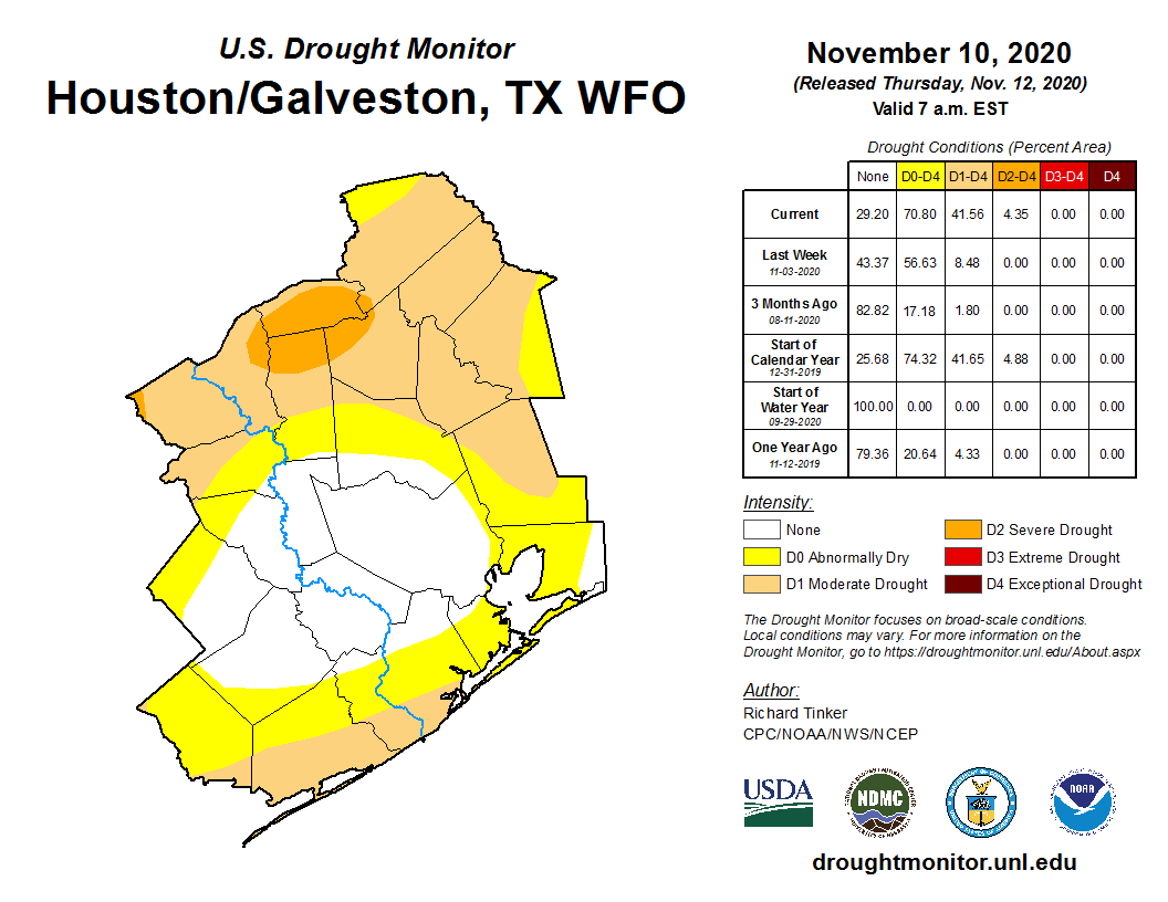
Last week’s drought monitor report had about 8.5 percent of the Houston region classified in drought. That has ballooned to over 40 percent this week.
Drought has expanded to about 40% of the Houston region, and it will not get any better over the next week or two. (Drought Monitor)
While Harris County is not in drought at this point, we are basically surrounded, including even a pocket of “severe” drought over Grimes, Walker, Madison, and Brazos Counties to our north. If you’re curious about the rest of the state, nearly 60 percent of Texas is classified as in drought, with about 20 percent (mainly in far west Texas) in extreme or exceptional drought. Droughts are one of the worst types of weather events to communicate because they can wreak havoc and are usually painfully slow to evolve. It’s pretty obvious right now though: We are seeing drought expand, we have little hope for meaningful rain over the next 10 days, and we are firmly in a La Niña, which is often a harbinger of a dry winter in the South. I know we have some farmers and other folks sensitive to drought that follow us. We are not yet ringing the alarm bells on a severe, long-duration drought for the region, but we are telling you that the players are trying to line up on the field. We’ll keep you posted.
Tropics
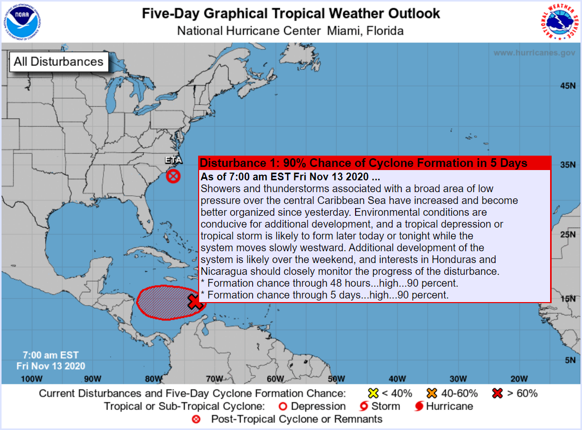
I just want to close with a quick note on the tropics. Invest 98L, the area tagged by the National Hurricane Center with a 90 percent chance of development is likely to become a depression or Tropical Storm Iota today or tomorrow in the Caribbean.
We are likely to see a Hurricane Iota in the Caribbean by Sunday or Monday. It’s not a threat to the Gulf, but it will likely impact areas in Central America that were just severely impacted by Hurricane Eta. (NOAA)
While it won’t be a threat to the Gulf, there is a chance that this one again rapidly intensifies and slams into Central America, not far from where Eta just hit, further cementing 2020’s status as an infamous hurricane season.