A Christmas cooldown is on the way for Houston

It’s beginning to not feel a lot like Christmas this morning, but that will soon change. A strong cold front remains on tap to move into Houston this evening, and this will bring blustery, cold conditions roaring back into the region. But first, we’ll have to deal with a gray and potentially rainy day.

Sunrise temperatures in Houston on Wednesday are quite warm. (Weather Bell)

Wednesday

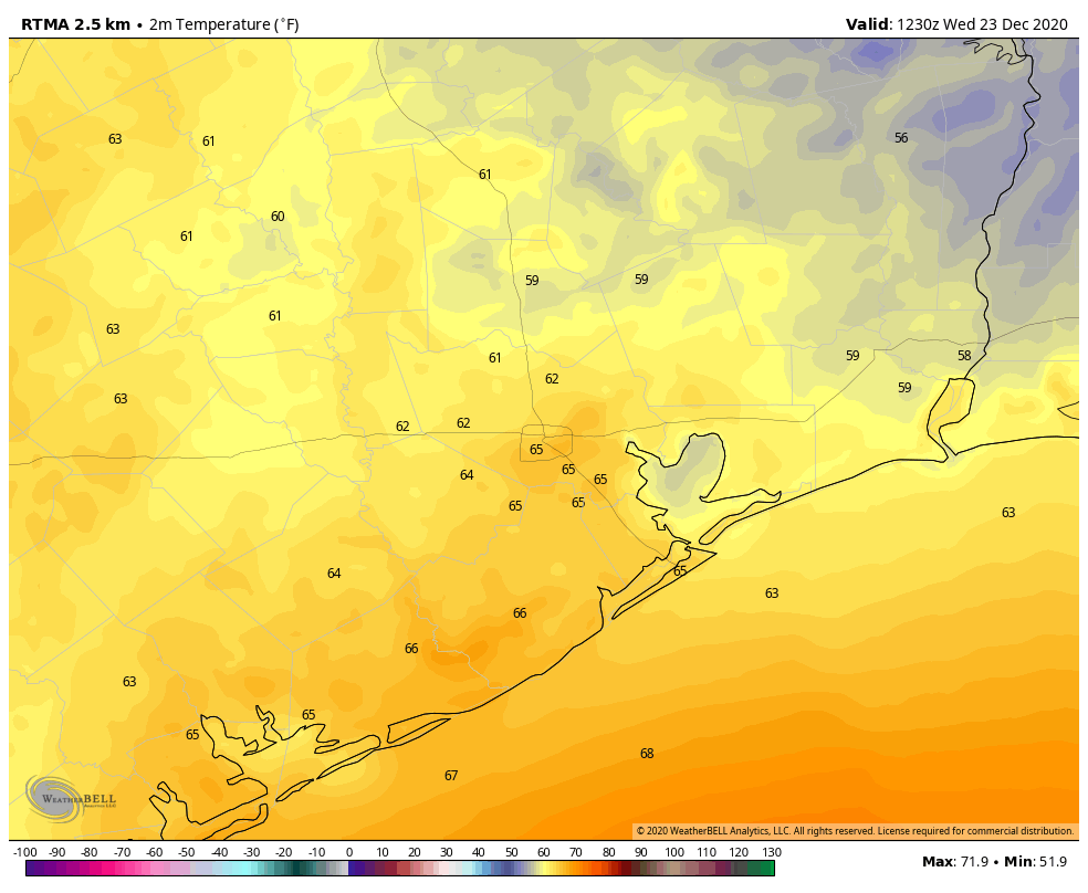
For December, temperatures this morning are rather balmy, in the mid- to upper-60s for most of the Houston area. We’re on our way to the mid-70s later today, with mostly cloudy skies and plenty of humidity. Winds will be noticeable out of the south, blowing up to 15 mph.

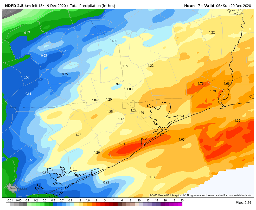
We should see scattered to widespread showers develop later this morning, and most of these should be light to moderate. Then, high-resolution models suggest stronger storms may develop near, and along the coast this afternoon and during the early evening hours. It’s possible the coast, then, may see as much as 1 inch of rain by around sunset. By then, a cold front will be on the way, likely pushing into central Houston by around 8pm or so, and reaching the coast by 10pm. A broken line of showers may develop along this front, and move swiftly into the Gulf with the front. After that, we’ll see wind and much drier, colder air.

Compared to the map above, showing Wednesday morning, temperatures on Thursday morning will be about 25 degrees colder. (Weather Bell)

Christmas Eve

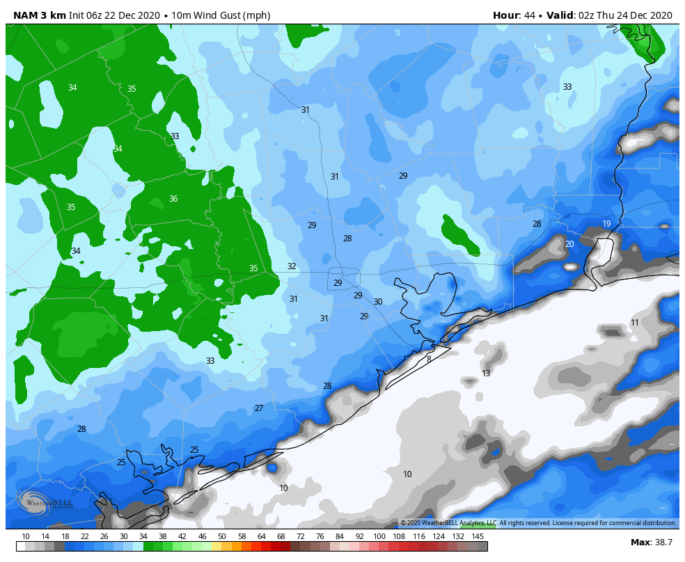
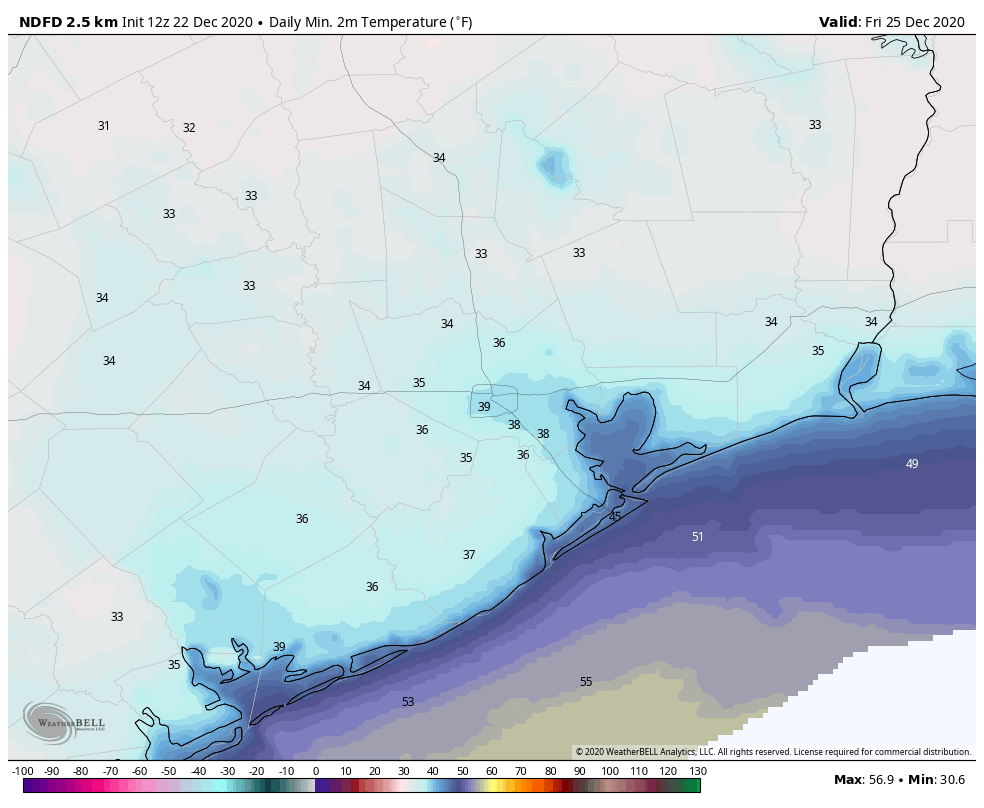
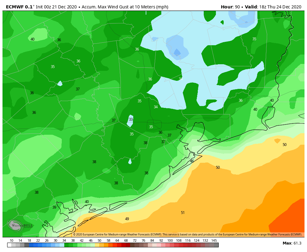
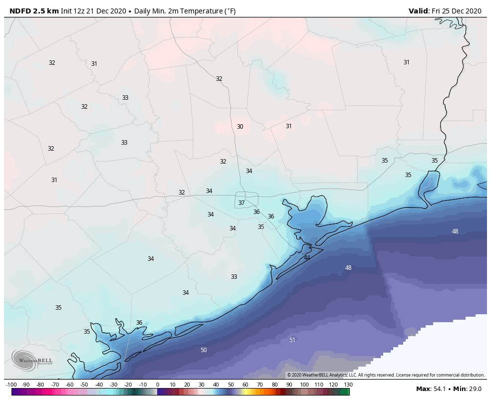
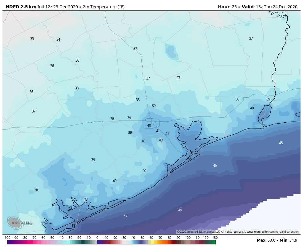
As we’ve been saying, winds are going to be howling along with the front, and Wednesday night after its passage. Make sure to account for loose articles outside, as we could see wind gusts of up to around 40 mph across much of the area overnight. These winds will begin to back off by Thursday morning, but we still should see sustained winds of around 15 mph during the day, with higher gusts. Highs will likely top out in the low 50s for most, even with the sunny skies. The winds will make it feel colder, so be sure and bundle up. Lows Thursday night will likely reach near freezing, but remain a few degrees above this threshold except for areas well inland.

Christmas Day

The holiday will start out cold, but daytime temperatures should reach about 60 degrees under mostly sunny skies. This will be as a winter day should feel! Lows Friday night will drop into the low 40s for most.

Saturday and Sunday

The weekend will bring partly sunny skies and a warming trend, with highs in the mid-60s on Saturday, and likely around 70 by Sunday. Some light showers may develop on Sunday ahead of a weaker front that may, or may not, make it all the way to the coast. For now, rain chances are fairly low.

Next week

We should see continued a warming trend next week, with our next front perhaps arriving around New Year’s Eve, or a bit earlier. This is likely to bring a healthy chance of rain and cold weather heading into 2021. Details to come!

Christmas will dawn clear and cold in Houston

Good morning. Houston will see a fairly turbulent front move through on Wednesday and Wednesday night, but we expect things to calm down by later on Christmas Eve, and certainly Christmas Day. All in all it seems like Mother Nature will be doing her part to ensure a festive holiday.

Tuesday

Temperatures have generally fallen into the upper 40s across Houston this morning, but we’ll warm to about 70 degrees under mostly sunny skies later today. Winds will be light, coming from the south or southeast, making for a pleasant day. As clouds increase this evening, and with the southerly flow, I doubt temperatures will drop too far below 60 degrees for most of the area.

Wind gust forecast for 8pm CT Wednesday as the front reaches the coast. Winds will continue to increase during the overnight hours. (Weather Bell)

Wednesday

This day should bring a lot more clouds, and humidity levels will continue to ramp up as highs reach the mid-70s. We’ll see the development of mostly light to moderate showers later on Wednesday, in advance of a cold front. These showers likely will drop only a few tenths of an inch of rain, at most, for most of the area, but we can’t rule out development of a few thunderstorms. The bigger story will be the winds accompanying a front that will move into Houston during the evening hours. Overnight, winds could gust as high as 40 mph over parts of the region, so you’ll definitely want to prepare for that. Lows will drop down to near 40 degrees for all but the coast.

Christmas Eve

This will be a sunny, blustery, and cold day. Highs will struggle to get above the mid-50s, and with a brisk northerly wind a chill will definitely be in the air. The night before Christmas will see temperatures dip into the 30s, but most of the region should remain just above freezing.

How cold will lows go on Christmas morning? (Weather Bell)

Christmas Day

We’ll see placid weather for the Christmas holiday, with mostly sunny skies and highs pushing up to around 60 degrees. Really, there will be nothing to complain about here.

Saturday and Sunday

The onshore flow will become more pronounced by Friday night, and this will lead to more clouds and warming temperatures. The weekend should see a mix of sunshine and clouds as highs get into the mid-60s on Saturday, and low 70s by Sunday. A weaker front may bring another shot of drier air by Sunday night.

Houston’s longest night will come with a celestial treat

Good morning. It’s the winter solstice, meaning today is the shortest day of the year in the northern hemisphere. For Houston, that means 10 hours, and 14 minutes of daylight, compared the longest day of 14 hours, 3 minutes in June. The further north you go, of course, the more extreme the differences become. Beginning tomorrow, days will gradually lengthen until the summer solstice.

Look to the southwest after sunset. (NASA/JPL-Caltech)

The shortest day also means the longest night—and this year there is a treat. Tonight Jupiter and Saturn will be making their closest observable conjunction in the night sky since the year 1226. This should be visible from most of Houston, despite the city’s bright lights. All one needs to do is go outside about an hour after sunset, around 6:30 pm. Find a clear view of the southwest horizon and look for the brightest object in the sky aside from the Moon. This will be Jupiter, and Saturn will be the fainter object next to it. These are the two largest planets in the Solar System, and although they appear in close proximity, they’re actually 456 million miles apart. Houston should hopefully have partly clear skies this evening.

Monday

Visibility across much of the area is good this morning, but fairly dense fog has developed right along the coast. It should dissipate by 9 am or so. As the high pressure that dominated Houston’s weather on Sunday moves off to the east, we’ll see winds turn to come from the south. This should allow temperatures to climb into the mid- to upper-60s later today beneath mostly sunny skies. Clouds will form tonight, likely keeping lows to around 50 degrees for much of Houston—although it will be cooler inland. Some fog may again develop early on Tuesday.

Tuesday

This will be another day like Monday, with mostly sunny skies after fog in the morning, and highs pushing up toward 70 degrees. Winds will be out of the south to southeast at 5 to 10 mph. Lows Tuesday night will be fairly warm for December, only falling into the upper 50s for most areas.

Wednesday

This will be the warmest day of the week, as our southerly flow continues. Despite partly cloudy skies, highs will get into the mid-70s. That will change later in the day as a cold front approaches, and passes through the region. Although confidence in the front’s timing is not absolute, we expect it to push through western areas during the afternoon hours, and off the coast during the evening. Some brief, light rain will be possible, but I don’t expect accumulations of more than a tenth of an inch, or two, for most areas. Lows Wednesday night will drop to about 40 degrees in Houston.

European model forecast for maximum wind gusts on Wednesday night, into Thursday morning. (Weather Bell)

Christmas Eve

This will be a cold and windy day. Most of the area should see winds gusting into the 30s on Wednesday evening into Thursday morning. Winds will slowly back down during the day, but will still be noticeable. With highs only rising into the 50s, despite sunny skies, it will feel chilly outside. Throughout the day we’re going to see very dry air moving into the region, and dewpoints are going to crash. This will set the stage for a cold night, with lows dropping into the 30s for all areas but the coast.

A cold Christmas morning, indeed. (Weather Bell)

Christmas Day

As a result of this, Christmas Day will start out cold. Skies should be partly to mostly sunny, however, and temperatures should warm to about 60 degrees for much of the area. It will be another chilly night, but most of the area stays in the 40s this time, probably.

Saturday and Sunday

The weekend should see a warming trend, with highs in the 60s, to possibly 70 degrees, by Sunday. Skies should be partly sunny. Another front may arrive Sunday night.

Storms may be a bit nasty east, and south of Houston today

Just a quick Saturday update to say the latest forecast modeling suggests rainfall later today could be a bit stronger than anticipated. At this point we think much of the region may see 1 to 2 inches of rainfall, with the possibility of 3 inches for areas south and east of Harris County. Some minor street flooding may briefly occur.

Updated rainfall outlook for Saturday. (Weather Bell)

In terms of timing, we expect rainfall chances to increase as the morning progresses, with a band of storms forming west of Houston shortly before noon and moving eastward. This band of storms should be near or off the coast by around 4pm this afternoon. A cold front will sweep through behind this band, rapidly bringing an end to the storm activity. We still anticipate mostly sunny conditions on Sunday, with highs in the mid-60s.

Looking further ahead, Christmas Day still looks quite cold. We will of course have a comprehensive update for you on Monday morning.