A review of the 2020 Atlantic hurricane season and Houston, Part II

To close out 2020, Eric and I put together two posts to summarize the Atlantic hurricane season, its effects on Houston, and implications for the future. Eric wrote Part I yesterday, which discusses the overall season and Hurricane Laura in particular. In Part II, today, I will discuss Tropical Storm Beta and what we can learn from this season about future hurricane activity.

Tropical Storm Beta

While Hurricane Laura was a clear and definitive threat, Tropical Storm Beta was a more difficult nut to crack. From the outset, we weren’t so much concerned about Beta as a wind threat, but rather as a slow-moving, disjointed storm capable of producing prolific rainfall. The tropical update I wrote back on September 15th discussed future Beta as an “untagged” disturbance that probably was more a concern for South Texas. “So while we aren’t particularly worried about this area, we do feel it’s one to keep an eye on.”

The issue with Beta was rainfall, and you could see a strong signal several days beforehand that it had the capability of producing double digit totals, as seen below from our Thursday morning post.
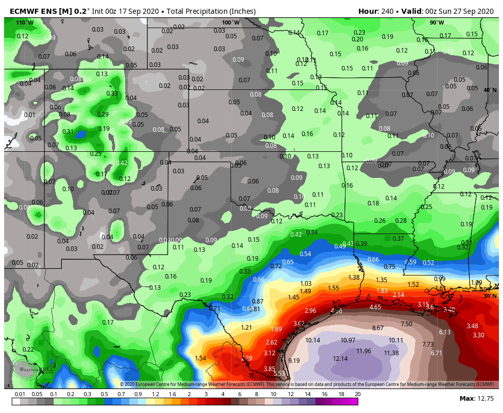
From 9/17: European model “average” rainfall forecast for now through Saturday, Sept. 26. (Weather Bell)

By that Thursday afternoon, a Tropical Depression 22 had formed, and modeling began to suggest it would come farther north. Our first real early season cold front around that time would help keep most of the rain offshore, but there were indications that the system itself could make a run at the Texas coast on its way out, moving slowly and dumping rain on the way.

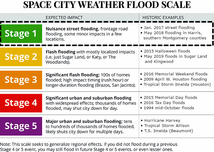
Initial rain forecasts began circulating on Friday as Beta’s track came more into focus, with as much as 10 to 15 inches forecast along the coast south of Houston. We also began playing up the coastal flooding risk posed by Beta. By Friday afternoon, we had classified Beta as a Stage 2 flood risk (south of I-10) using our SCW Flood Scale.

On Saturday, we got a good handle on the general theme of how Beta would unfold, likely as a rainfall issue but not too terribly serious, some wind but not so much to cause widespread power outages, and considerable coastal flooding. Beta reached peak intensity over the Gulf on Saturday, though at the time, it was still expected to become a hurricane upon approach to the middle Texas Coast.
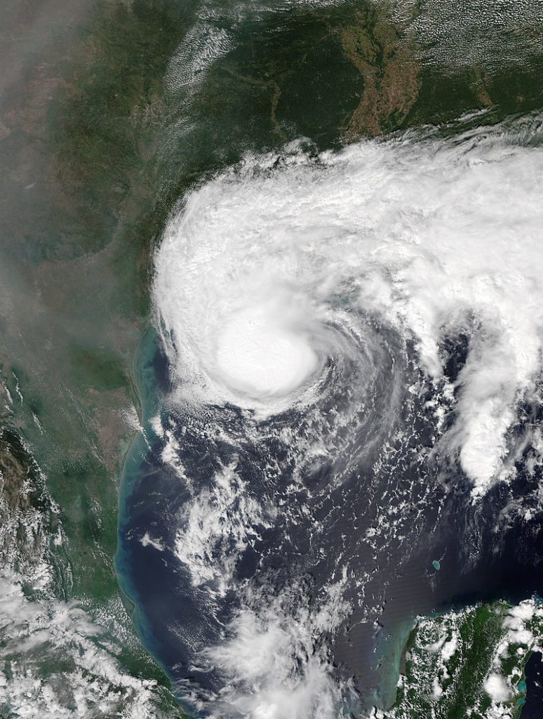
Tropical Storm Beta at peak intensity in the Gulf on Saturday, September 19th. (NASA)

Beta’s rainfall was expected to still be pretty aggressive, with upwards of 4 to 12 inches expected and at least the risk of 10 to 20 inches in a worst-case scenario.
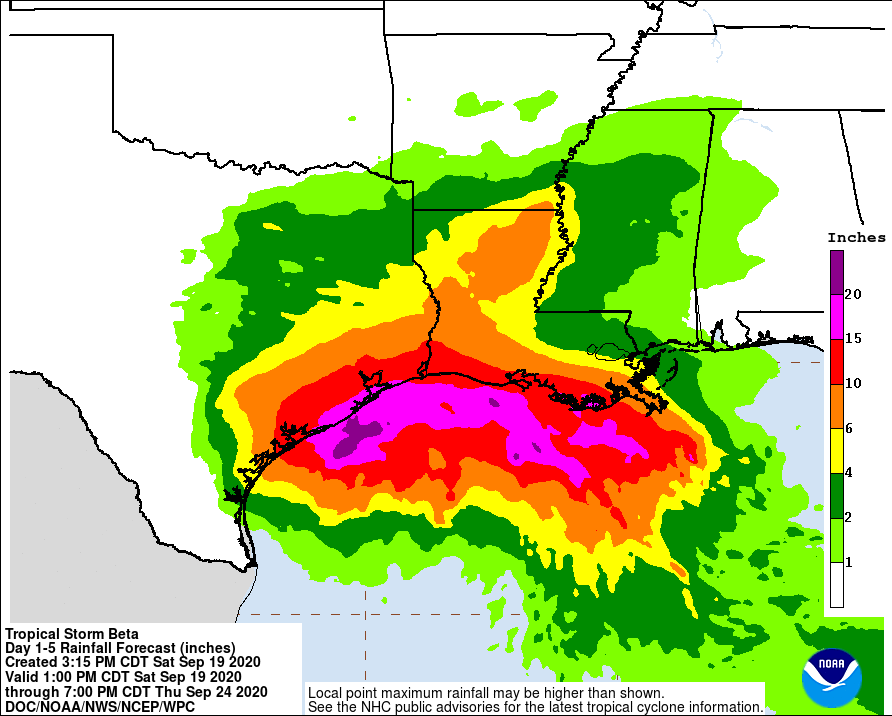
Beta’s Saturday evening rainfall forecast through 7pm CT Thursday, September 24th. (NOAA/WPC)

We knew it had potential to cause headaches, but we did not feel it was going to become a catastrophic storm.

By Sunday the 20th, I began to check out because becoming a second-time dad took some precedence. But the rains began as Beta tracked toward the coast near Matagorda and then along it to the northeast through Houston. On Sunday, about 1 to 2 inches fell across eastern and southern Harris County and northeast parts of Fort Bend County, mainly near Sugar Land. Beta tried valiantly to strengthen on Sunday afternoon but failed.

Monday saw Beta begin its peak assault on the Texas coast, with heavy bands of rainfall setting up over and south of Houston by evening. Close to 10 inches of rain had fallen south of Houston, causing some bayous to come out of banks. Rain continued off and on into Tuesday morning, leading to more widespread flooding that caused us to escalate things to a Stage 3 flood event south of I-10. Thankfully, the rains tapered off a good bit on Tuesday, and the heavy rain on Tuesday night setup a bit farther northeast than Monday night, allowing for less flooding problems. By Wednesday, Beta had moved away, and that was that.

From a return-period standpoint, Beta’s 48 hour total rains were mostly classified by the Harris County Flood Control District as between a 2 and 10-year event (or a storm that has anywhere from a 10 to 50 percent chance of occurring in any given year). The lone exception appeared to be portions of Sims Bayou that may have been closer to a 50-year type of storm, meaning in any given year there’s about 2 percent probability that we’ll exceed certain rainfall totals. You can see that while Beta was certainly a respectable storm, it paled in comparison to our recent major flooding events from tropical systems.
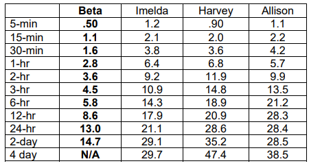
Beta was certainly no slouch, but it also was not a Harvey or Allison or even Imelda for our area. (Harris County Flood Control District)

Beta flooded 20 to 25 homes along Clear Creek or Brays Bayou and a handful of homes (due to drainage) near the South Loop at Cullen. Because the maximum rate of rainfall during Beta was “only” about 2 to 3 inches in an hour, and there were breaks, the area was able to mostly avoid severe, widespread bayou and/or home flooding. Harris County Flood Control estimated that nearly 1,000 homes were spared flooding due to recent capital improvements along Brays and Sims Bayous.
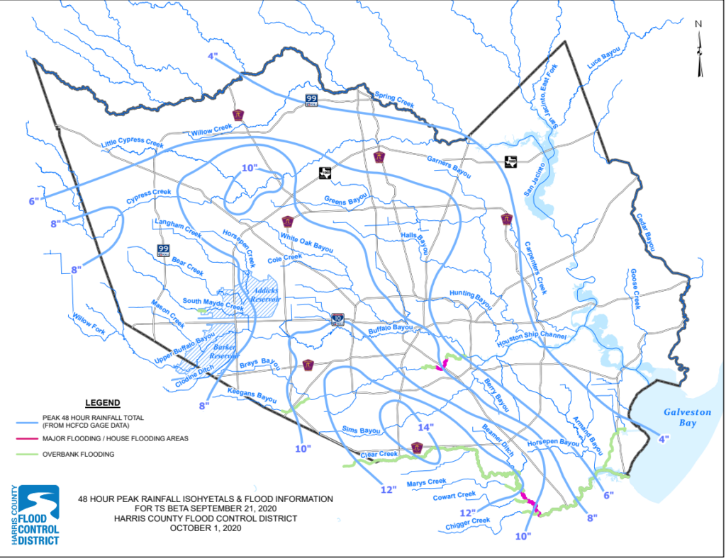
A maximum rainfall bullseye of over 14″ fell over Clear Creek and Sims Bayou in southern Harris County; click to enlarge. (HCFCD)

As far as storm surge and coastal flooding went, the other element of this storm, it was estimated that surge levels hit 1 to 4 feet above ground level along the western shore of Galveston Bay and on the Gulf Coast, a firm moderate coastal flooding event for many areas.

Laura reminded us of our exposure and vulnerability to a major hurricane, while Beta was a good reminder of the rainfall hazards we must accept by living in this part of the world. While storms like Allison and Harvey are thankfully rare (though perhaps becoming less rare as time goes on), storms like Beta, which produce heavy rainfall and sub-catastrophic flooding, are pretty typical in Texas, which sees slow-moving tropical systems fairly frequently. Again, this may be occurring more frequently as climate change impacts become more common. It’s important to have flood insurance if you live in this area, and it’s important to have a plan if flooding from rain or bayou rises impacts your home.

For those that utilize our Space City Weather flood scale, Beta will go in the books as a lower-end Stage 3 flood. While it may have fallen in between stage 2 and 3 to some extent, given the widespread flooding we experienced and coastal impacts, we feel a low-end 3 makes sense. If you read about the historic Stage 3 examples, we would probably rank Beta just under all of those listed.

The future

The first question we expect to be asked is,  “Does the fact that this hurricane season was so active mean next season has higher odds of being more active also?” And we would say, it absolutely does not mean that.

The 10 most active Atlantic hurricane seasons on record prior to 2020 averaged 20 tropical storms, 11 hurricanes, and an accumulated cyclone energy (ACE) of 186. The years that followed averaged 15 tropical storms, 7 hurricanes, and an ACE of 106. Those years that followed saw anywhere from below average activity to borderline hyperactivity. Is it possible that next year is also a very busy hurricane season? Certainly. But it’s almost equally likely that it could be a below average season if history is any guide. One of the best examples of this is the 2006 hurricane season. Preseason forecasts were very active, coming off the absurdly destructive 2005 season with high odds for both significant storms and impactful ones. What happened? We got 10 named storms and minimal U.S. impacts.

We can begin to take a very, very wild swing at what next season may setup as in terms of La Niña or El Niño (ENSO).

If we look at the CFS model from NOAA and the European (ECMWF) model, we can see their long-range forecasts for what “state” the tropical Pacific might be in several months down the road. Per the ECMWF model, while La Niña may be with us into spring, it looks to begin to perhaps fade toward May or June 2021.
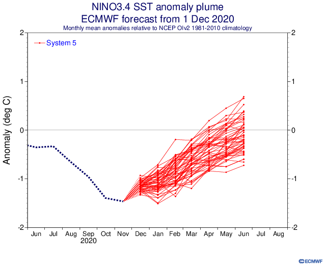
The European model forecast for sea surface temperature anomalies in the tropical Pacific shows a weakening La Niña this coming spring. (ECMWF)

As far as the CFS model goes, it shows basically the same idea: Weakening La Niña heading toward next summer.
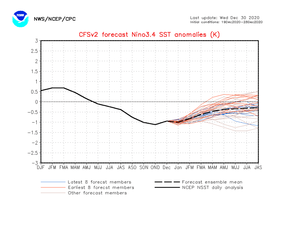
The CFS model of tropical Pacific sea surface temperature anomalies also shows a weakening La Niña next spring & summer (NOAA)

The huge caveat here is that these types of long-range forecasts of ENSO are notoriously fickle. A lot can and probably will change between now and next summer. However, the early read on things is that conditions may start the season in a borderline La Niña and then get less hospitable as the season wears on. There’s far more to consider besides ENSO, but those are mostly things we can’t really speculate on this far in advance. One thing we can at least look at are sea surface temperature anomalies (SSTs). Here’s a look at how SSTs have changed from 2001-2010 to 2011-2020.
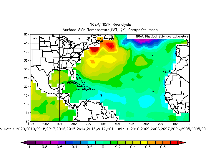
Sea surface temperatures have warmed across most of the Atlantic basin (including the Gulf) during the peak months of August to October when you compare the 2001-2010 period to 2011-2020. (NOAA)

Most of the Atlantic Basin has warmed during the peak months of August, September, and October, with the exception of some of the lower-latitudes between the Caribbean and Africa. This is likely due to both a combination of climate change and some cyclical background noise. Either way, it’s not a good thing.

If we want to expand further on climate change, we could talk about rapid intensification (RI), as climate change is likely leading to more RI and more significant RI. I went through a number of scientific papers on the subject recently. While there are still some mixed results about exactly which basins around the globe are more likely to see more RI and exactly how significant it will be, the general trend is pointing toward more of it in more storms. 2020 only furthered that concept.

In the chart above, you can see how 2020 had the most storms with intensifications of 70 to 90 kts. in 36 hours of any prior modern hurricane season. Obviously with more storms, you should get more rapidly intensifying storms, but 2020 was sort of at some higher level than usual. And truthfully, it serves as another data point in a sea of them in recent years.

Putting all this together, you would probably expect next season to be near-average, maybe a little above, but nothing like 2020’s hurricane season. Still, if we are indeed moving into a world with more rapidly intensifying storms, it won’t take a large number of them in a hurricane season to cause problems, especially in the Gulf, as we witnessed with Hanna, Laura, Delta, and Zeta this year.

Last day of 2020—so of course we’re going to see a stormy mess

So far the forecast for Houston remains on track. Nearly all of the heavy rainfall has remained west of Interstate 45, with generally 1 to 4 inches falling between Wednesday afternoon and Thursday morning. A few areas, such as western Montgomery County, saw as much as 5 inches. Now, we’ve got to get through one more day before skies clear this evening and the new year dawns brighter.

Thursday daytime

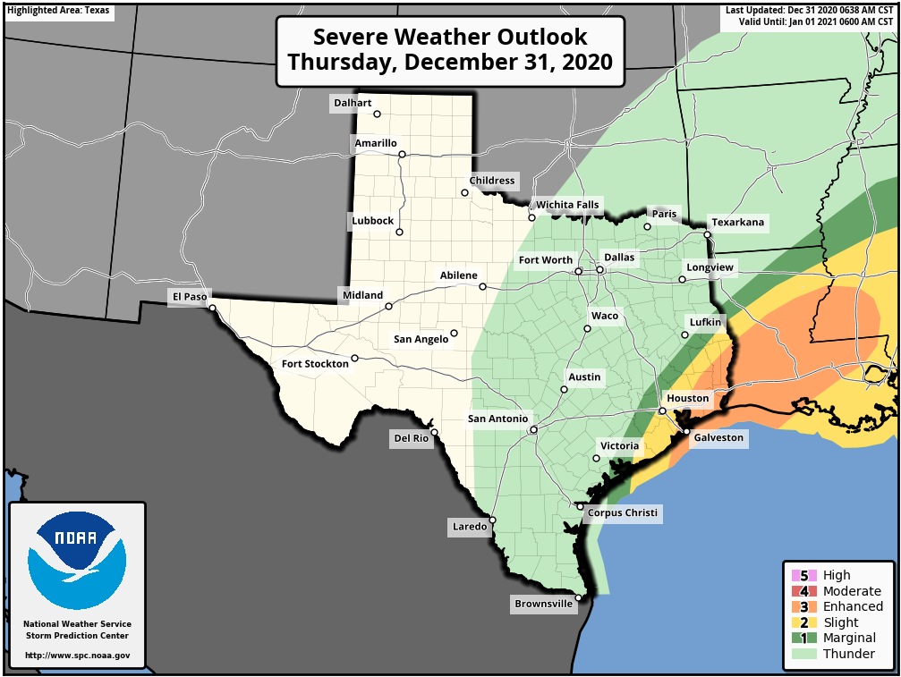
After storms waned during the wee hours of Thursday, we’re starting to see activity fire back up west of Houston around sunrise. This mass of storms should generally move from west to east during the daylight hours, bringing an additional 1 to 3 inches across much of the Houston area. However, the forecast will be complicated by the front’s interaction with a low-pressure system presently along the Texas coast, near Corpus Christi. As this low moves north today, it could induce some severe weather to the south and east of Houston—especially the closer one gets to Beaumont and Port Arthur. The threat will be strong winds amidst severe thunderstorms, and possibly a few tornadoes. The area of greatest threat is shown below.

Severe weather outlook for New Year’s Eve. (NOAA)

New Year’s Eve evening

The cold front presently draped across the Houston region will finally lift to the northeast this afternoon and evening. I think rains should be gone from the central Houston area by around 4 to 6pm CT today, and rapidly pull away to the east after that time. Temperatures after sunset will quickly drop into the 40s, with brisk westerly winds blowing at 15 to 20 mph, and higher gusts. Bottom line: If you’re outside when the clock strikes midnight, it will “feel” like it is in the 30s.

New Year’s Day

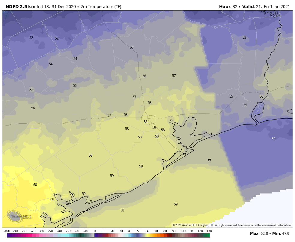
Lows will drop to around 40 degrees before rebounding into the upper 50s on New Year’s Day. After some morning clouds, skies should be mostly sunny.

Forecast high temperatures for New Year’s Day. (Weather Bell)

Saturday and Sunday

Expect more sunshine throughout the weekend, with highs in the mid-50s on Saturday, and low 60s on Sunday.

Next week

Houston will likely see a slow warming trend next week before another front arrives on Wednesday or Thursday to keep our weather reasonably cool. This one may bring some additional rain, but nothing like we’ve been experiencing with the current front.

2020 Hurricane Season

If you missed it, we published Part I of our hurricane season wrap-up on Wednesday, and will publish Part II later today.

Heavy rain mainly west of I-45 may cause some flooding tonight

Rainfall this afternoon was quite vigorous across the Houston area, with a few places seeing as much as an inch of rain in about 15 minutes’ time.

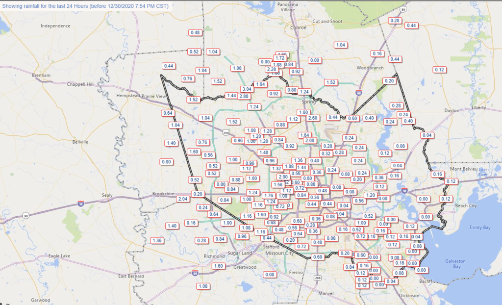
Rainfall has been mixed across the area, but some places in western Harris County have seen 3 inches of rain or more so far. (Harris County Flood Control)

This has added up with the gauge at Spring Creek and SH 249 for instance already over 3 inches of rain today. For most areas, this has been manageable with just some minor street flooding.

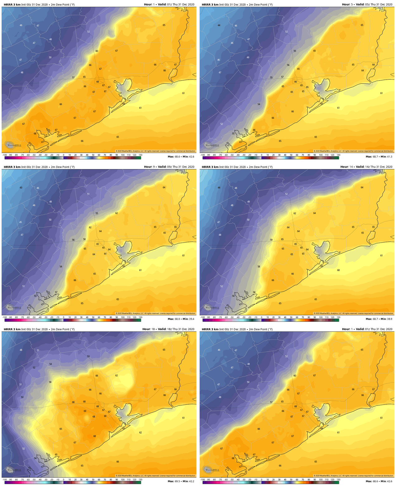
The trouble tonight is that the front is going to approach and stall west of I-45 for a time. You can see this well on the HRRR model for example, which is showing the front (roughly the boundary between warmer and cooler colors here) stalled out over Harris County tonight and into tomorrow morning. This animation runs from 7 PM Wednesday to Noon Thursday.

HRRR model shows the cold front basically stalled out over western Harris County most of tonight and early Thursday, leading to repeating rounds of rainfall, some heavy. (Weather Bell)

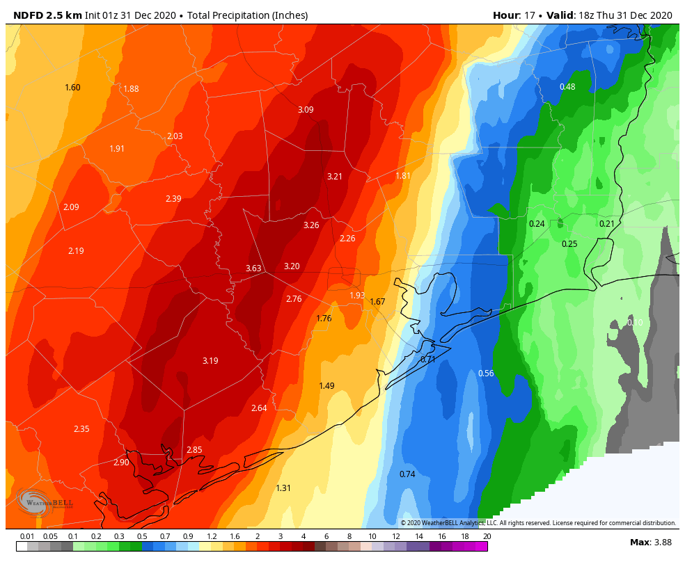
In this time, repeated rounds of rainfall, some heavy, will impact areas primarily west of I-45 (until you get north of Conroe). Additional rainfall during this time on top of what has already fallen, will average about an inch or so east of Houston and 1 to 4 inches west of the city (presume about 1 to 3 inches in the city itself). There will likely be some pockets of higher amounts up to 5 or 6 inches or so west of Houston. Those higher amounts would be most likely in western Harris, western Montgomery, Grimes, Fort Bend, Wharton, or Waller Counties.

Forecast rainfall on top of what has fallen through 7 PM Wednesday will be 1 to 3 inches on average with higher amounts possible west of Houston. (Weather Bell)

This could lead to some localized flooding, and for that reason, we are going to implement the Space City Weather Flood Scale at Stage 1 for tonight and Thursday.

(Space City Weather)

We will go with a Stage 1 event for the western half of the area, which generally means mostly nuisance street flooding. But there will likely be rises on area creeks as well, particularly Willow Creek, upper Spring Creek, and upper Little Cypress Creek. So we will watch and escalate if necessary, but we think this will behave for the most part in our area. Still, please exercise caution, especially if you have to be out for whatever reason tonight and tomorrow morning. A Flash Flood Watch is posted for Houston and points west through tomorrow afternoon.

Rain should rapidly end from southwest to northeast across the region tomorrow afternoon and evening.

In addition to the rainfall, we did see a tornado warning at one point for Harris and Fort Bend Counties this afternoon. We think the severe threat will be fairly minor tonight, but we can’t entirely rule out a storm or two trying to get a little excitable, particularly if it can develop east of the front. For folks in Galveston, Chambers, and Liberty Counties, this would be the primary way you would see rain tonight, from a rogue storm or shower ahead of the main action to the west. Not too serious a concern right now, but something we’ll keep tabs on.

More from Eric in the morning!

A review of the 2020 Atlantic hurricane season and Houston, Part I

Today and tomorrow, Matt and I will be publishing two posts to summarize the 2020 Atlantic hurricane season, its effects on Houston, and implications for the future. In Part I, today, I will discuss the overall activity this season, and share some thoughts about Hurricane Laura. Part II, tomorrow, will focus on Tropical Storm Beta and what we can learn from this season about future hurricane activity.

2020 season

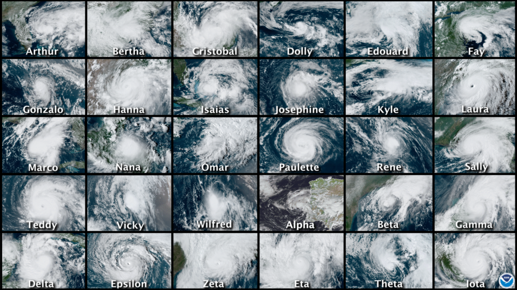
The numbers for the 2020 season are sobering. Across the Atlantic basin—which includes the Atlantic Ocean, Caribbean Sea, and Gulf of Mexico—there were a total of 30 tropical storms and hurricanes. This surpassed the previous record of 28 set in the year 2005, the historic year of Katrina, Rita, and Wilma. For only the second time, this year, forecasters at the National Hurricane Center in Miami ran out of names and had to resort to using the Greek alphabet.

From Arthur to Iota, what a year it was. (NOAA)

Notably, a dozen of these tropical storms and hurricanes made landfall in the United States, crushing the previous record of nine landfalling tropical storms or hurricanes set in 1916. The state of Louisiana alone experienced five landfalls. (Thanks to the tremendous results of our 2020 fundraiser, Space City Weather will donate $5,000 to SBP, to assist with that state’s recovery efforts). At least one part of Louisiana fell under coastal watches or warnings for tropical activity for a total of 474 hours this summer and fall. And Hurricane Laura, discussed below, became the strongest hurricane to make landfall in Louisiana since 1856.

Harris County’s Jeff Lindner has catalogued some of this year’s other superlatives:

  • On September 14, five tropical cyclones were ongoing at the same time in the Atlantic basin (Sally, Paulette, Rene, Teddy, and Vicky). This ties September 1971 for the most number of tropical cyclones at the same time in the basin.
  • On September 18, three tropical cyclones formed within in six-hour window (Wilfred, Alpha, and Beta). This is only the second time in recorded history that three tropical cyclones have formed in such a short time period (1893).
  • Ten tropical storms formed in the month of September, the most for any month on record
  • A total of 10 systems experienced rapid intensification (35 mph increase in wind speed in 24 hours), Hanna, Laura, Sally, Teddy, Gamma, Delta, Epsilon, Zeta, Eta, and Iot).
  • Hurricanes Delta, Iota, and Eta experienced winds speed increases over 100 mph in 36 hours or less.
  • Of the 6 major hurricanes in 2020, four were in October and November, and bore Greek alphabet names (Delta, Epsilon, Eta, and Iota).
  • Hurricanes Eta and Iota both made landfall only 15 miles apart along the Nicaragua coast both as category 4 hurricanes.
  • Hurricane Iota (160 mph) became the latest category 5 hurricane on record in the Atlantic basin, and the second strongest November hurricane on record only behind the 1932 Cuba hurricane (175mph)
  • NOAA hurricane hunters flew a total of 86 missions for 678 flight hours and 102 eyewall passages. A total of 1,772 dropsondes were deployed.

Despite all of this, however, the 2020 Atlantic season was not all that extraordinary by some important measurements. Perhaps our best tool for determining a season’s overall activity is “accumulated cyclone energy,” or ACE, which sums up the intensity and duration of storms. For example, a weak, short-lived tropical storm counts for almost nothing, whereas a major, long-lived hurricane will quickly rack up dozens of points. The ACE value for the 2020 Atlantic season was 179.8. This significantly higher than the climatological norm for ACE values (about 104), but does not quite make the top 10 busiest Atlantic seasons on record, which is paced by the 1933 and 2005 seasons.

The bottom line is that the 2020 hurricane season was in line with our expectations for 2020 to produce a total cluster of a year. Fortunately, we survived. In Matt’s post on Thursday, he’ll discuss what this may mean for the 2021 season.

Hurricane Laura

It’s also worth reflecting for a moment on what I consider to be the most threatening storm of the year for Houston. There was a time in late August when it appeared that Hurricane Laura might strike Houston as a major hurricane. Personally, it was rather unsettling.

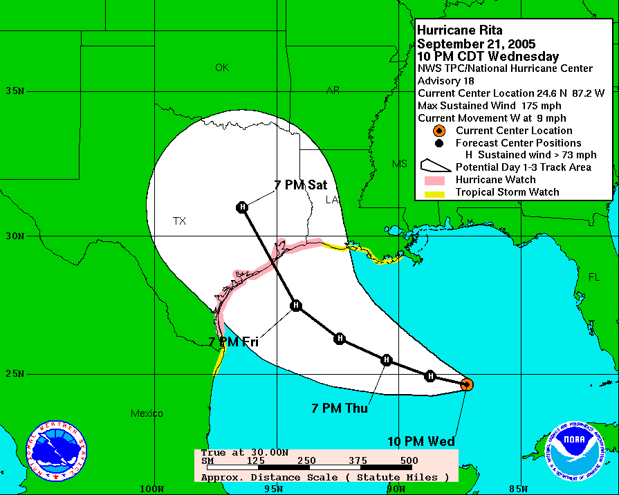
I first began writing extensively about hurricanes back in 2005. This was before I had become a meteorologist, and just after I started a blog for the Houston Chronicle. First, I tracked Hurricane Katrina and then, much closer to home, there was Rita. You may not remember the storm, or it may not have formed much of an impression on you. But it certainly did on me. I distinctly recall the evening of September 21, 2005—a Wednesday. Rita had intensified to 175 mph over the central Gulf of Mexico, and it was forecast to make landfall a little more than two days later just below Houston on the Texas coast. This was the worst-case scenario for our region. I’d bought a home in the Clear Lake area a couple of years earlier. Not going to lie, this one scared me. Eventually, Rita weakened some, and turned, making landfall near the Texas-Louisiana border.

Hurricane Rita forecast for Sept 21, 2005, about 30 hours before landfall. (National Hurricane Center)

Since then, Rita has been the measuring stick for me in terms of dreading a hurricane landfall. And in those 15 years, no storm has ranked so highly as Laura did in late August. Why? Because although Houston has been battered by a strong storm surge (Hurricane Ike) and massive floodstorm (Harvey) in the last dozen years, it has not seen a major wind storm in nearly six decades. That was the potential Laura had with a track that could have come to Texas, across a very warm Gulf of Mexico. Ultimately, that didn’t happen, Laura turned away from Houston and made a devastating landfall in Louisiana.

Thanks to fine forecasting and smart calls by local officials, the greater Houston area was spared a major evacuation. But Laura was a close call in many ways for the nation’s fourth largest city. And I won’t soon forget it.

Sponsor Note from Reliant

A big thank you goes to the Space City Weather team for keeping Houstonians informed during the 2020 hurricane season. Just as Eric and Matt provide hype-free forecasts to ensure readers are prepared for a storm, Reliant keeps Houston powered with personalized electricity plans and back-up power solutions. Reliant is also here to help before, during and after the storm with helpful guides, tips and information on reliantstormcenter.com. We all hope for a quiet hurricane season in 2021, but know we’ll be informed and in good hands with Eric and Matt should any storms develop. Thanks for all you do, SCW!